|
| Mesoscale Discussion 1235 |
|
< Previous MD Next MD >
|
|
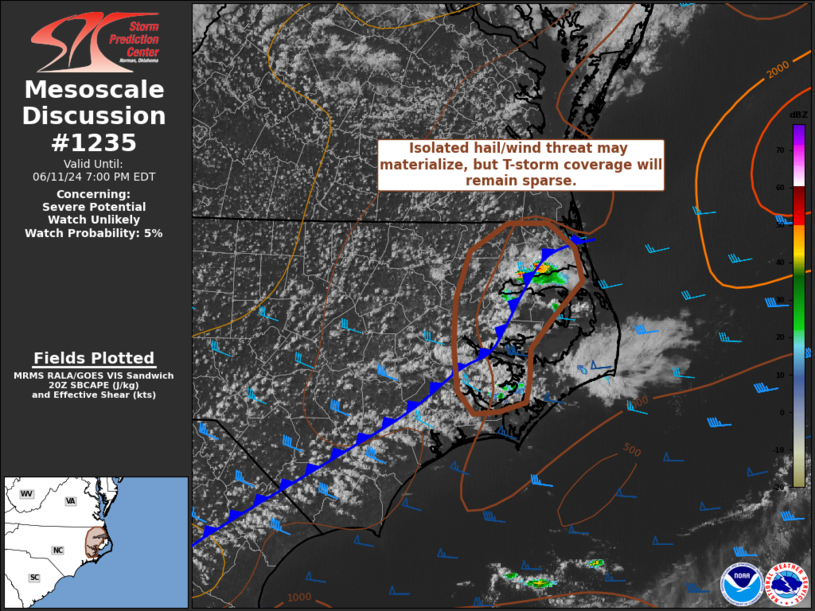
   Mesoscale Discussion 1235
   NWS Storm Prediction Center Norman OK
   0355 PM CDT Tue Jun 11 2024

   Areas affected...Eastern North Carolina

   Concerning...Severe potential...Watch unlikely

   Valid 112055Z - 112300Z

   Probability of Watch Issuance...5 percent

   SUMMARY...Isolated thunderstorms developing along outflow and/or
   sea-breeze boundaries may pose a hail/wind threat this afternoon.
   Thunderstorm coverage will remain sparse, precluding watch issuance.

   DISCUSSION...Thunderstorms have been ongoing along the eastern NC
   coast for much of the afternoon, but earlier convection displayed
   somewhat poor organization/longevity. More recently (within the past
   30 minutes), convective intensity has increased based on GOES IR
   cloud top temperatures and lightning trends - likely the result of
   increasing SBCAPE associated with peak diurnal warming. Forecast
   soundings suggest that 30-40 knot winds within the 5-6 km layer
   should elongate hodographs sufficient to promote some storm
   organization of the stronger/deeper cells with an attendant risk of
   large hail. Dewpoint depressions between 20-30 F are noted inland,
   suggesting that a deep, well-mixed boundary layer is in place that
   may promote strong to severe downburst winds. However,
   east/northeasterly storm motions to the cool side of the
   sea-breeze/outflow boundaries may limit the potential for severe
   downbursts. Additional convection along the boundaries appears
   possible, but in the absence of stronger forcing for ascent,
   thunderstorm coverage (and any associated severe hazards) should
   remain very limited.

   ..Moore/Smith.. 06/11/2024

   ...Please see www.spc.noaa.gov for graphic product...

   ATTN...WFO...AKQ...MHX...

   LAT...LON   36307704 36547663 36547621 36337593 36047585 35747615
               35457640 35197640 34997644 34917673 34907700 35097717
               35397719 35487721 35887718 36307704
|
|
Top/All Mesoscale Discussions/Forecast Products/Home
|
|


 @NWSSPC