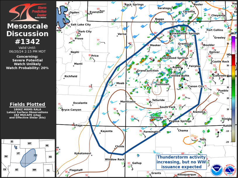
   Mesoscale Discussion 1342
   NWS Storm Prediction Center Norman OK
   0109 PM CDT Thu Jun 20 2024

   Areas affected...Western Colorado and the Four Corners Region

   Concerning...Severe potential...Watch unlikely

   Valid 201809Z - 202015Z

   Probability of Watch Issuance...20 percent

   SUMMARY...Convective coverage is expected to increase this afternoon
   as temperatures warm into the upper 70s and low-to-mid 80s across
   the higher terrain of the intermountian west. Scattered
   thunderstorms capable of isolated damaging wind gusts and hail are
   possible, but WW issuance is not expected at this time.

   DISCUSSION...Convection is increasing over portions of W CO, with
   coverage expected to expand into the Four Corners region later this
   afternoon as convective temperatures are reached ahead of an
   approaching upper level trough.

   Morning sounding observations from Grand Junction and Flagstaff
   suggest wind shear supportive of organized convection, with deep
   layer bulk shear values in the 55-60kt range, and 500-1000 J/kg
   SBCAPE present in the SPC mesoanalysis. However, high LCL heights
   and widespread convective coverage will result in outflow dominant
   storms and frequent storm interactions, limiting overall severe
   potential.

   Still, a few reports of hail and damaging winds can be expected with
   any stronger, organized convection that develops. Given overall
   uncertainty in convective organization, however, WW issuance is not
   expected at this time.

   ..Halbert/Lyons/Hart.. 06/20/2024

   ...Please see www.spc.noaa.gov for graphic product...

   ATTN...WFO...PUB...BOU...ABQ...GJT...FGZ...SLC...

   LAT...LON   40850643 40840601 40600565 39350548 38540535 37830554
               37190681 36790747 36490806 36180867 35910917 35970982
               36231026 36771060 37241077 37501062 37861030 38680995
               39250950 39860847 40720716 40850643
|


 @NWSSPC