|
| Mesoscale Discussion 1343 |
|
< Previous MD Next MD >
|
|
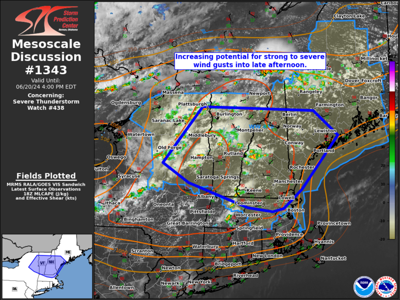
   Mesoscale Discussion 1343
   NWS Storm Prediction Center Norman OK
   0130 PM CDT Thu Jun 20 2024

   Areas affected...northeast NY to parts of New England

   Concerning...Severe Thunderstorm Watch 438...

   Valid 201830Z - 202000Z

   The severe weather threat for Severe Thunderstorm Watch 438
   continues.

   SUMMARY...An isolated mixed wind/hail risk should transition to a
   scattered damaging wind threat as individual cells loosely congeal
   into an east-southeast moving cluster through late afternoon.

   DISCUSSION...Numerous single cell thunderstorms are ongoing from
   parts of central NY to western ME and northward into southeast ON
   and south QC. The more prominent activity will likely persist in
   association with a well-defined MCV over northeast NY. With this
   corridor just north of the peak buoyancy plume over the Hudson
   Valley, characterized by MLCAPE around 2500 J/kg, further
   intensification is expected over the next 2-3 hours. Recent VWP data
   from CXX and TYX confirm a belt of modestly enhanced 3-6 km AGL
   westerlies around 25-30 kts. This should serve to loosely organize a
   multicell cluster across VT/NH/southwest ME and perhaps part of MA
   later this afternoon. Recent HRRR runs have been consistent on this
   scenario with 12Z NSSL-MPAS guidance. With surface temperatures
   having already warmed through the mid 90s from eastern MA into
   southwest ME, these hot temperatures should boost severe wind gust
   potential, and may yield peak gusts into the 55-70 mph range.

   ..Grams.. 06/20/2024

   ...Please see www.spc.noaa.gov for graphic product...

   ATTN...WFO...GYX...BOX...BTV...ALY...

   LAT...LON   44717359 44627019 44076946 42887057 42477113 42407146
               42487221 43037399 43467477 44717359
|
|
Top/All Mesoscale Discussions/Forecast Products/Home
|
|


 @NWSSPC