|
| Mesoscale Discussion 1349 |
|
< Previous MD Next MD >
|
|
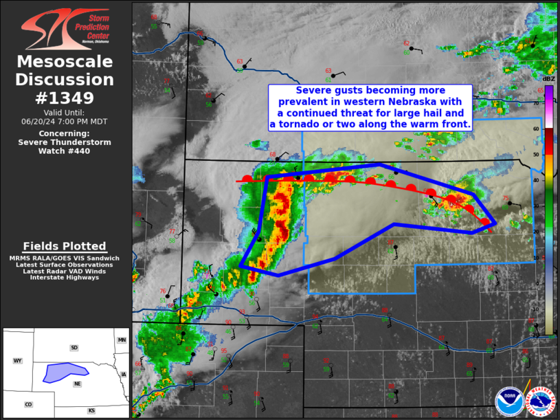
   Mesoscale Discussion 1349
   NWS Storm Prediction Center Norman OK
   0633 PM CDT Thu Jun 20 2024

   Areas affected...Western into central Nebraska

   Concerning...Severe Thunderstorm Watch 440...

   Valid 202333Z - 210100Z

   The severe weather threat for Severe Thunderstorm Watch 440
   continues.

   SUMMARY...Severe winds will generally become the predominant threat
   in western/central Nebraska with time as an MCS moves east. Storms
   favorably interacting with the warm front, particularly those of
   discrete mode, will still pose some risk of a tornado and large
   hail.

   DISCUSSION...Storms continue to grow upscale into an MCS in western
   Nebraska. Severe winds will likely be on the increase with this
   activity--the Alliance, NE ASOS recently recorded a 70 kt gust.
   Temperatures ahead of this line of storms remain in the upper 80s to
   low 90s F and the low-level jet should increase over the next few
   hours, aiding in storm maintenance. Along the warm front, more
   discrete storms in northwest Cherry County and east of Ainsworth
   continue. These storms will pose the greatest risk for large hail
   and possibly a tornado should they interact favorably with the warm
   front. The storm east of Ainsworth produced one reported tornado so
   far. The storm has become more HP/messy in character; however, the
   mesocyclone has periodically intensified over the last couple of
   hours as well.

   ..Wendt.. 06/20/2024

   ...Please see www.spc.noaa.gov for graphic product...

   ATTN...WFO...LBF...CYS...

   LAT...LON   41720309 42130281 42810268 42960082 42589928 42239893
               42129931 42240058 41810156 41610247 41720309
|
|
Top/All Mesoscale Discussions/Forecast Products/Home
|
|


 @NWSSPC