|
| Mesoscale Discussion 1361 |
|
< Previous MD Next MD >
|

|
   Mesoscale Discussion 1361
   NWS Storm Prediction Center Norman OK
   0358 PM CDT Fri Jun 21 2024

   Areas affected...Central Montana

   Concerning...Severe Thunderstorm Watch 442...

   Valid 212058Z - 212230Z

   The severe weather threat for Severe Thunderstorm Watch 442
   continues.

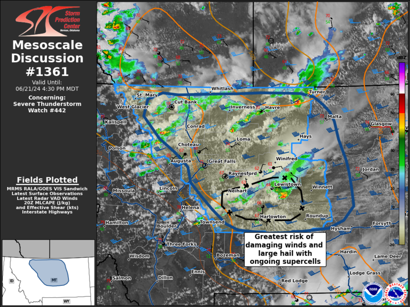
   SUMMARY...The severe thunderstorm threat continues for WW 442. The
   threat for damaging winds and hail is greatest in Central MT where
   two isolated supercells have developed and begun tracking
   east-southeast. Local WW extension may be needed further N into
   Phillips County due to a southeastward moving supercell in Blaine
   County.

   DISCUSSION...Thunderstorm coverage has increased this afternoon over
   the northern Rockies in W MT, with clusters of cells beginning to
   move off of the higher terrain into the better buoyancy and shear.
   These cells are capable of producing 1+ inch hail and damaging
   winds.

   In Central MT, two isolated supercells have developed and begun
   moving east-southeast. These storms are in an environment of
   1000-1500 J/kg MLCAPE and 45-50 kts of deep layer shear, supporting
   a continued damaging wind and large hail threat.

   Further east in Blaine County, near the Canadian border, a storm has
   developed that may track outside of the watch area, warranting local
   WW extension.

   ..Halbert/Weinman.. 06/21/2024

   ...Please see www.spc.noaa.gov for graphic product...

   ATTN...WFO...BYZ...GGW...TFX...

   LAT...LON   47721223 47991270 48401317 48731307 48871264 48831217
               48871114 48881046 48890977 48880900 48880860 48810822
               48660797 48510776 48320765 47980753 47570733 47310725
               47000719 46680716 46410744 46250788 46210863 46210888
               46180898 46180954 46241042 46361076 46631113 46901149
               47151176 47451185 47721223
|
|
Top/All Mesoscale Discussions/Forecast Products/Home
|
|


