Note:
The expiration time in the watch graphic is amended if the watch is
replaced, cancelled or extended.
Note:
Note:
The expiration time in the watch graphic is amended if the watch is
replaced, cancelled or extended.
Note: Click for
Watch Status Reports.
SEL2
URGENT - IMMEDIATE BROADCAST REQUESTED
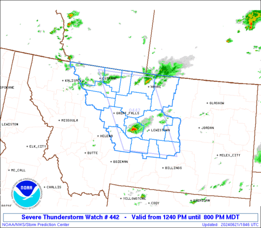
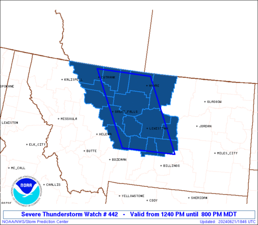
Severe Thunderstorm Watch Number 442
NWS Storm Prediction Center Norman OK
1240 PM MDT Fri Jun 21 2024
The NWS Storm Prediction Center has issued a
* Severe Thunderstorm Watch for portions of
Central Montana
* Effective this Friday afternoon and evening from 1240 PM until
800 PM MDT.
* Primary threats include...
Scattered large hail likely with isolated very large hail events
to 3 inches in diameter possible
Scattered damaging wind gusts to 70 mph possible
A tornado or two possible
SUMMARY...Isolated supercell thunderstorms will develop and track
across the watch area this afternoon and evening, capable of very
large hail and damaging wind gusts. An isolated tornado or two is
also possible.
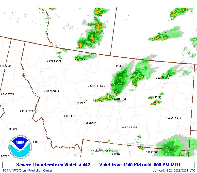
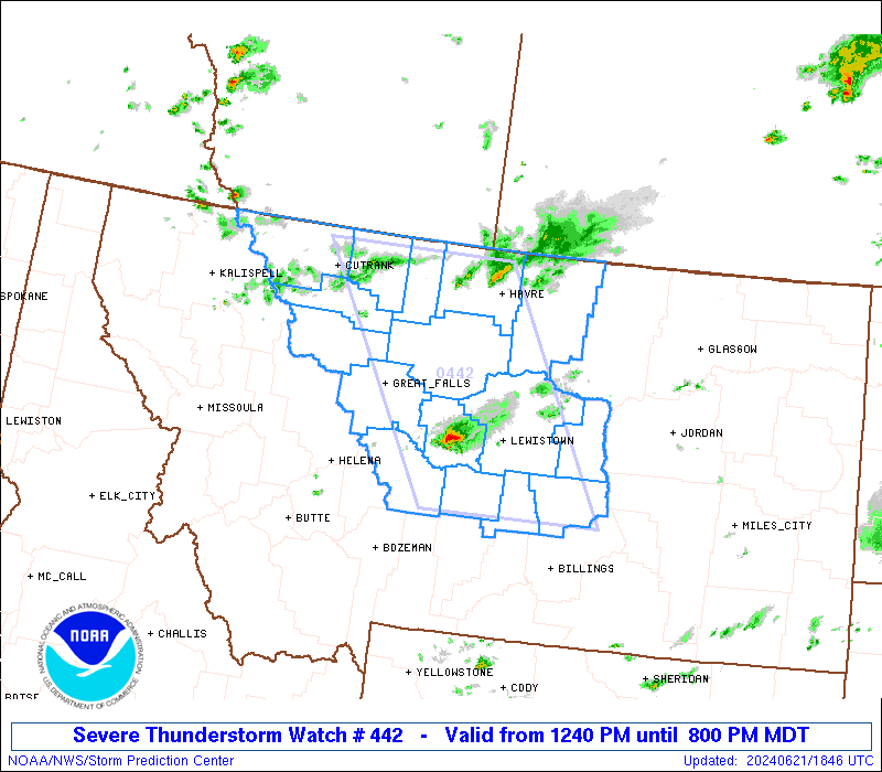
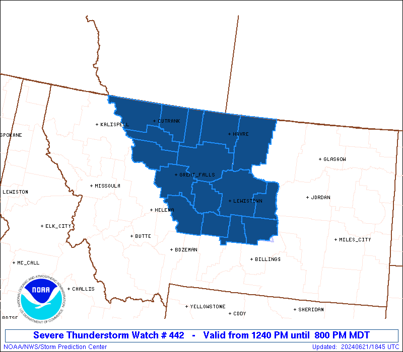
The severe thunderstorm watch area is approximately along and 65
statute miles east and west of a line from 65 miles west northwest
of Havre MT to 30 miles east southeast of Harlowton MT. For a
complete depiction of the watch see the associated watch outline
update (WOUS64 KWNS WOU2).
PRECAUTIONARY/PREPAREDNESS ACTIONS...
REMEMBER...A Severe Thunderstorm Watch means conditions are
favorable for severe thunderstorms in and close to the watch area.
Persons in these areas should be on the lookout for threatening
weather conditions and listen for later statements and possible
warnings. Severe thunderstorms can and occasionally do produce
tornadoes.
&&
OTHER WATCH INFORMATION...CONTINUE...WW 441...
AVIATION...A few severe thunderstorms with hail surface and aloft to
3 inches. Extreme turbulence and surface wind gusts to 60 knots. A
few cumulonimbi with maximum tops to 500. Mean storm motion vector
27035.
...Hart
   SEL2

   URGENT - IMMEDIATE BROADCAST REQUESTED
   Severe Thunderstorm Watch Number 442
   NWS Storm Prediction Center Norman OK
   1240 PM MDT Fri Jun 21 2024

   The NWS Storm Prediction Center has issued a

   * Severe Thunderstorm Watch for portions of
     Central Montana

   * Effective this Friday afternoon and evening from 1240 PM until
     800 PM MDT.

   * Primary threats include...
     Scattered large hail likely with isolated very large hail events
       to 3 inches in diameter possible
     Scattered damaging wind gusts to 70 mph possible
     A tornado or two possible

   SUMMARY...Isolated supercell thunderstorms will develop and track
   across the watch area this afternoon and evening, capable of very
   large hail and damaging wind gusts.  An isolated tornado or two is
   also possible.

   The severe thunderstorm watch area is approximately along and 65
   statute miles east and west of a line from 65 miles west northwest
   of Havre MT to 30 miles east southeast of Harlowton MT. For a
   complete depiction of the watch see the associated watch outline
   update (WOUS64 KWNS WOU2).

   PRECAUTIONARY/PREPAREDNESS ACTIONS...

   REMEMBER...A Severe Thunderstorm Watch means conditions are
   favorable for severe thunderstorms in and close to the watch area.
   Persons in these areas should be on the lookout for threatening
   weather conditions and listen for later statements and possible
   warnings. Severe thunderstorms can and occasionally do produce
   tornadoes.

   &&

   OTHER WATCH INFORMATION...CONTINUE...WW 441...

   AVIATION...A few severe thunderstorms with hail surface and aloft to
   3 inches. Extreme turbulence and surface wind gusts to 60 knots. A
   few cumulonimbi with maximum tops to 500. Mean storm motion vector
   27035.

   ...Hart
 Note:
The Aviation Watch (SAW) product is an approximation to the watch area.
The actual watch is depicted by the shaded areas.
Note:
The Aviation Watch (SAW) product is an approximation to the watch area.
The actual watch is depicted by the shaded areas.
   SAW2
   WW 442 SEVERE TSTM MT 211840Z - 220200Z
   AXIS..65 STATUTE MILES EAST AND WEST OF LINE..
   65WNW HVR/HAVRE MT/ - 30ESE 3HT/HARLOWTON MT/
   ..AVIATION COORDS.. 55NM E/W /57WNW HVR - 37NW BIL/
   HAIL SURFACE AND ALOFT..3 INCHES. WIND GUSTS..60 KNOTS.
   MAX TOPS TO 500. MEAN STORM MOTION VECTOR 27035.

   LAT...LON 48890966 46250789 46251061 48891252

   THIS IS AN APPROXIMATION TO THE WATCH AREA.  FOR A
   COMPLETE DEPICTION OF THE WATCH SEE WOUS64 KWNS
   FOR WOU2.
Watch 442 Status Report Messages:
STATUS REPORT #5 ON WW 442

VALID 220040Z - 220140Z

THE SEVERE WEATHER THREAT CONTINUES ACROSS THE ENTIRE WATCH AREA.

..WENDT..06/22/24

ATTN...WFO...TFX...BYZ...GGW...

&&

STATUS REPORT FOR WS 442

SEVERE WEATHER THREAT CONTINUES FOR THE FOLLOWING AREAS

MTC005-013-015-027-035-041-045-051-059-069-073-099-101-220140-

MT
.    MONTANA COUNTIES INCLUDED ARE

BLAINE		     CASCADE		 CHOUTEAU
FERGUS		     GLACIER		 HILL
JUDITH BASIN	     LIBERTY		 MEAGHER
PETROLEUM	     PONDERA		 TETON
TOOLE
$$


THE WATCH STATUS MESSAGE IS FOR GUIDANCE PURPOSES ONLY.  PLEASE
REFER TO WATCH COUNTY NOTIFICATION STATEMENTS FOR OFFICIAL
INFORMATION ON COUNTIES...INDEPENDENT CITIES AND MARINE ZONES
CLEARED FROM SEVERE THUNDERSTORM AND TORNADO WATCHES.
$$

STATUS REPORT #4 ON WW 442

VALID 212340Z - 220040Z

THE SEVERE WEATHER THREAT CONTINUES ACROSS THE ENTIRE WATCH AREA.

FOR ADDITIONAL INFORMATION SEE MESOSCALE DISCUSSION 1368

..WENDT..06/21/24

ATTN...WFO...TFX...BYZ...GGW...

&&

STATUS REPORT FOR WS 442

SEVERE WEATHER THREAT CONTINUES FOR THE FOLLOWING AREAS

MTC005-013-015-027-035-037-041-045-051-059-065-069-073-099-101-
107-220040-

MT
.    MONTANA COUNTIES INCLUDED ARE

BLAINE		     CASCADE		 CHOUTEAU
FERGUS		     GLACIER		 GOLDEN VALLEY
HILL		     JUDITH BASIN	 LIBERTY
MEAGHER 	     MUSSELSHELL	 PETROLEUM
PONDERA 	     TETON		 TOOLE
WHEATLAND
$$


THE WATCH STATUS MESSAGE IS FOR GUIDANCE PURPOSES ONLY.  PLEASE
REFER TO WATCH COUNTY NOTIFICATION STATEMENTS FOR OFFICIAL
INFORMATION ON COUNTIES...INDEPENDENT CITIES AND MARINE ZONES
CLEARED FROM SEVERE THUNDERSTORM AND TORNADO WATCHES.
$$

STATUS REPORT #3 ON WW 442

VALID 212255Z - 212340Z

THE SEVERE WEATHER THREAT CONTINUES ACROSS THE ENTIRE WATCH AREA.

..WENDT..06/21/24

ATTN...WFO...TFX...BYZ...GGW...

&&

STATUS REPORT FOR WS 442

SEVERE WEATHER THREAT CONTINUES FOR THE FOLLOWING AREAS

MTC005-013-015-027-035-037-041-045-051-059-065-069-073-099-101-
107-212340-

MT
.    MONTANA COUNTIES INCLUDED ARE

BLAINE		     CASCADE		 CHOUTEAU
FERGUS		     GLACIER		 GOLDEN VALLEY
HILL		     JUDITH BASIN	 LIBERTY
MEAGHER 	     MUSSELSHELL	 PETROLEUM
PONDERA 	     TETON		 TOOLE
WHEATLAND
$$


THE WATCH STATUS MESSAGE IS FOR GUIDANCE PURPOSES ONLY.  PLEASE
REFER TO WATCH COUNTY NOTIFICATION STATEMENTS FOR OFFICIAL
INFORMATION ON COUNTIES...INDEPENDENT CITIES AND MARINE ZONES
CLEARED FROM SEVERE THUNDERSTORM AND TORNADO WATCHES.
$$

STATUS REPORT #2 ON WW 442

VALID 212035Z - 212140Z

THE SEVERE WEATHER THREAT CONTINUES ACROSS THE ENTIRE WATCH AREA.

..WEINMAN..06/21/24

ATTN...WFO...TFX...BYZ...GGW...

&&

STATUS REPORT FOR WS 442

SEVERE WEATHER THREAT CONTINUES FOR THE FOLLOWING AREAS

MTC005-013-015-027-035-037-041-045-051-059-065-069-073-099-101-
107-212140-

MT
.    MONTANA COUNTIES INCLUDED ARE

BLAINE		     CASCADE		 CHOUTEAU
FERGUS		     GLACIER		 GOLDEN VALLEY
HILL		     JUDITH BASIN	 LIBERTY
MEAGHER 	     MUSSELSHELL	 PETROLEUM
PONDERA 	     TETON		 TOOLE
WHEATLAND
$$


THE WATCH STATUS MESSAGE IS FOR GUIDANCE PURPOSES ONLY.  PLEASE
REFER TO WATCH COUNTY NOTIFICATION STATEMENTS FOR OFFICIAL
INFORMATION ON COUNTIES...INDEPENDENT CITIES AND MARINE ZONES
CLEARED FROM SEVERE THUNDERSTORM AND TORNADO WATCHES.
$$

STATUS REPORT #1 ON WW 442

VALID 211935Z - 212040Z

THE SEVERE WEATHER THREAT CONTINUES ACROSS THE ENTIRE WATCH AREA.

..GRAMS..06/21/24

ATTN...WFO...TFX...BYZ...GGW...

&&

STATUS REPORT FOR WS 442

SEVERE WEATHER THREAT CONTINUES FOR THE FOLLOWING AREAS

MTC005-013-015-027-035-037-041-045-051-059-065-069-073-099-101-
107-212040-

MT
.    MONTANA COUNTIES INCLUDED ARE

BLAINE		     CASCADE		 CHOUTEAU
FERGUS		     GLACIER		 GOLDEN VALLEY
HILL		     JUDITH BASIN	 LIBERTY
MEAGHER 	     MUSSELSHELL	 PETROLEUM
PONDERA 	     TETON		 TOOLE
WHEATLAND
$$


THE WATCH STATUS MESSAGE IS FOR GUIDANCE PURPOSES ONLY.  PLEASE
REFER TO WATCH COUNTY NOTIFICATION STATEMENTS FOR OFFICIAL
INFORMATION ON COUNTIES...INDEPENDENT CITIES AND MARINE ZONES
CLEARED FROM SEVERE THUNDERSTORM AND TORNADO WATCHES.
$$
Note:
Click for Complete Product Text.
Tornadoes
Probability of 2 or more tornadoes
|
Low (20%)
|
Probability of 1 or more strong (EF2-EF5) tornadoes
|
Low (5%)
|
Wind
Probability of 10 or more severe wind events
|
Mod (40%)
|
Probability of 1 or more wind events > 65 knots
|
Low (20%)
|
Hail
Probability of 10 or more severe hail events
|
Mod (60%)
|
Probability of 1 or more hailstones > 2 inches
|
Mod (40%)
|
Combined Severe Hail/Wind
Probability of 6 or more combined severe hail/wind events
|
High (90%)
|
For each watch, probabilities for particular events inside the watch
(listed above in each table) are determined by the issuing forecaster.
The "Low" category contains probability values ranging from less than 2%
to 20% (EF2-EF5 tornadoes), less than 5% to 20% (all other probabilities),
"Moderate" from 30% to 60%, and "High" from 70% to greater than 95%.
High values are bolded and lighter in color to provide awareness of
an increased threat for a particular event.


 @NWSSPC