|
| Mesoscale Discussion 1370 |
|
< Previous MD Next MD >
|
|
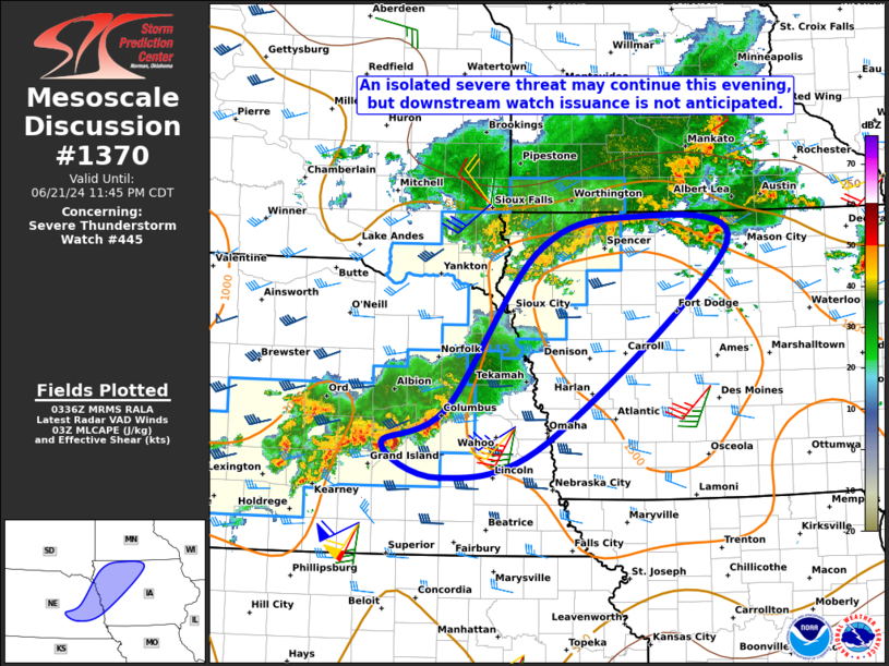
   Mesoscale Discussion 1370
   NWS Storm Prediction Center Norman OK
   1038 PM CDT Fri Jun 21 2024

   Areas affected...Parts of eastern NE and western/northern IA

   Concerning...Severe Thunderstorm Watch 445...

   Valid 220338Z - 220445Z

   The severe weather threat for Severe Thunderstorm Watch 445
   continues.

   SUMMARY...An isolated severe threat may continue this evening, but
   downstream watch issuance is not anticipated at this time.

   DISCUSSION...The leading cell in a band of loosely organized
   convection in central/eastern NE recently produced a measured severe
   wind gust to 50 kt (58 mph) in Merrick County NE. A separate area of
   thunderstorms also remains over northern IA, along and near a front.
   Recent VWP trends from KOAX/KDMX have shown a gradual increase in a
   low-level jet, and related 0-1-km shear. Transient low-level
   rotation and perhaps a brief tornado will remain possible in the
   short term with updrafts embedded within these broader areas of
   convection. But, isolated severe/damaging winds up to 60 mph should
   remain the primary threat in the short term, with around 1000-1500
   J/kg of MLCAPE and a minimum in MLCIN noted in the latest
   mesoanalysis estimates of instability across eastern NE and
   western/northern IA. A local extension in area and expiration time
   of Severe Thunderstorm Watch 445 remains a possibility across parts
   of eastern NE and vicinity. But, given current expectations that the
   overall severe threat will become increasingly isolated with time
   late this evening, additional/downstream watch issuance is not
   currently anticipated.

   ..Gleason/Edwards.. 06/22/2024

   ...Please see www.spc.noaa.gov for graphic product...

   ATTN...WFO...DMX...FSD...OAX...GID...

   LAT...LON   41149816 41509729 43099607 43459482 43179344 41159592
               40789737 41149816
|
|
Top/All Mesoscale Discussions/Forecast Products/Home
|
|


 @NWSSPC