Note:
The expiration time in the watch graphic is amended if the watch is
replaced, cancelled or extended.
Note:
Note:
The expiration time in the watch graphic is amended if the watch is
replaced, cancelled or extended.
Note: Click for
Watch Status Reports.
SEL5
URGENT - IMMEDIATE BROADCAST REQUESTED
Severe Thunderstorm Watch Number 445
NWS Storm Prediction Center Norman OK
330 PM CDT Fri Jun 21 2024
The NWS Storm Prediction Center has issued a
* Severe Thunderstorm Watch for portions of
Northwest Iowa
Southwest Minnesota
Central and Eastern Nebraska
Southeast South Dakota
* Effective this Friday afternoon and evening from 330 PM until
1100 PM CDT.
* Primary threats include...
Scattered large hail and isolated very large hail events to 2
inches in diameter possible
Scattered damaging wind gusts to 70 mph possible
A tornado or two possible
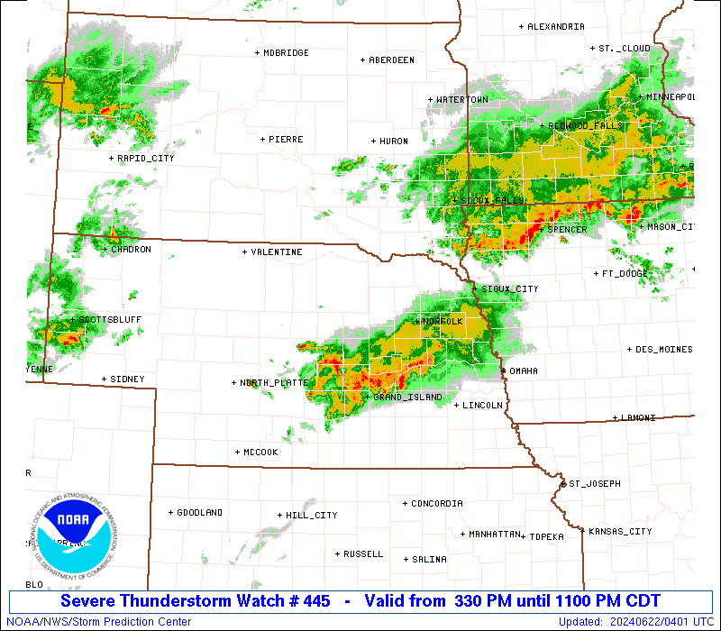
SUMMARY...Thunderstorms are expected to develop this afternoon along
a boundary extending from southwest to northeast Nebraska and into
northwest Iowa. A few supercells are possible, capable of large
hail and damaging wind gusts. A tornado or two could also occur.
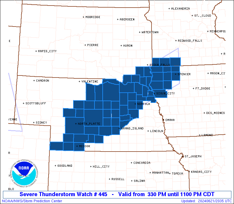
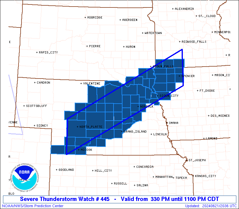
The severe thunderstorm watch area is approximately along and 50
statute miles north and south of a line from 40 miles southwest of
North Platte NE to 25 miles north northeast of Spencer IA. For a
complete depiction of the watch see the associated watch outline
update (WOUS64 KWNS WOU5).
PRECAUTIONARY/PREPAREDNESS ACTIONS...
REMEMBER...A Severe Thunderstorm Watch means conditions are
favorable for severe thunderstorms in and close to the watch area.
Persons in these areas should be on the lookout for threatening
weather conditions and listen for later statements and possible
warnings. Severe thunderstorms can and occasionally do produce
tornadoes.
&&
OTHER WATCH INFORMATION...CONTINUE...WW 441...WW 442...WW
443...WW 444...
AVIATION...A few severe thunderstorms with hail surface and aloft to
2 inches. Extreme turbulence and surface wind gusts to 60 knots. A
few cumulonimbi with maximum tops to 500. Mean storm motion vector
25025.
...Hart
   SEL5

   URGENT - IMMEDIATE BROADCAST REQUESTED
   Severe Thunderstorm Watch Number 445
   NWS Storm Prediction Center Norman OK
   330 PM CDT Fri Jun 21 2024

   The NWS Storm Prediction Center has issued a

   * Severe Thunderstorm Watch for portions of
     Northwest Iowa
     Southwest Minnesota
     Central and Eastern Nebraska
     Southeast South Dakota

   * Effective this Friday afternoon and evening from 330 PM until
     1100 PM CDT.

   * Primary threats include...
     Scattered large hail and isolated very large hail events to 2
       inches in diameter possible
     Scattered damaging wind gusts to 70 mph possible
     A tornado or two possible

   SUMMARY...Thunderstorms are expected to develop this afternoon along
   a boundary extending from southwest to northeast Nebraska and into
   northwest Iowa.  A few supercells are possible, capable of large
   hail and damaging wind gusts.  A tornado or two could also occur.

   The severe thunderstorm watch area is approximately along and 50
   statute miles north and south of a line from 40 miles southwest of
   North Platte NE to 25 miles north northeast of Spencer IA. For a
   complete depiction of the watch see the associated watch outline
   update (WOUS64 KWNS WOU5).

   PRECAUTIONARY/PREPAREDNESS ACTIONS...

   REMEMBER...A Severe Thunderstorm Watch means conditions are
   favorable for severe thunderstorms in and close to the watch area.
   Persons in these areas should be on the lookout for threatening
   weather conditions and listen for later statements and possible
   warnings. Severe thunderstorms can and occasionally do produce
   tornadoes.

   &&

   OTHER WATCH INFORMATION...CONTINUE...WW 441...WW 442...WW
   443...WW 444...

   AVIATION...A few severe thunderstorms with hail surface and aloft to
   2 inches. Extreme turbulence and surface wind gusts to 60 knots. A
   few cumulonimbi with maximum tops to 500. Mean storm motion vector
   25025.

   ...Hart
 Note:
The Aviation Watch (SAW) product is an approximation to the watch area.
The actual watch is depicted by the shaded areas.
Note:
The Aviation Watch (SAW) product is an approximation to the watch area.
The actual watch is depicted by the shaded areas.
SAW5
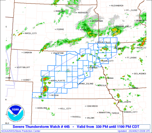
WW 445 SEVERE TSTM IA MN NE SD 212030Z - 220400Z
AXIS..50 STATUTE MILES NORTH AND SOUTH OF LINE..
40SW LBF/NORTH PLATTE NE/ - 25NNE SPW/SPENCER IA/
..AVIATION COORDS.. 45NM N/S /34SW LBF - 58S RWF/
HAIL SURFACE AND ALOFT..2 INCHES. WIND GUSTS..60 KNOTS.
MAX TOPS TO 500. MEAN STORM MOTION VECTOR 25025.
LAT...LON 41440122 44239496 42789496 40000122
THIS IS AN APPROXIMATION TO THE WATCH AREA. FOR A
COMPLETE DEPICTION OF THE WATCH SEE WOUS64 KWNS
FOR WOU5.
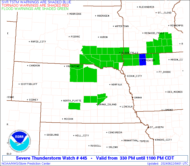
Watch 445 Status Report Messages:
STATUS REPORT #6 ON WW 445
VALID 220345Z - 220440Z
SEVERE WEATHER THREAT CONTINUES RIGHT OF A LINE FROM 10 SW EAR TO
25 S BUB TO 20 WNW OLU TO 15 N OLU TO 20 NNW TQE TO 35 N SUX TO
20 WSW FRM.
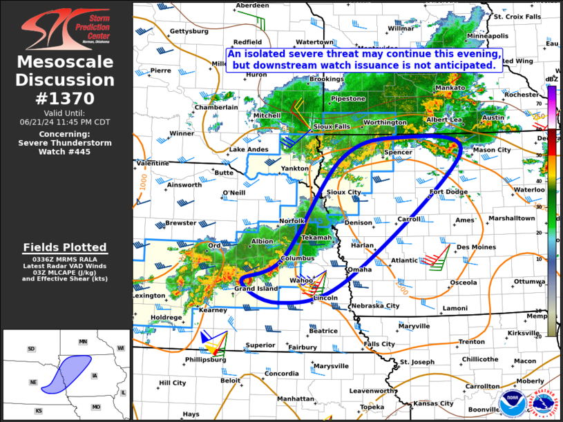
FOR ADDITIONAL INFORMATION SEE MESOSCALE DISCUSSION 1370
..GLEASON..06/22/24
ATTN...WFO...FSD...OAX...LBF...GID...GLD...
&&
STATUS REPORT FOR WS 445
SEVERE WEATHER THREAT CONTINUES FOR THE FOLLOWING AREAS
IAC035-041-059-141-149-167-193-220440-
IA
. IOWA COUNTIES INCLUDED ARE
CHEROKEE CLAY DICKINSON
O'BRIEN PLYMOUTH SIOUX
WOODBURY
$$
NEC019-023-037-077-079-081-093-121-125-141-143-163-175-185-
220440-
NE
. NEBRASKA COUNTIES INCLUDED ARE
BUFFALO BUTLER COLFAX
GREELEY HALL HAMILTON
HOWARD MERRICK NANCE
PLATTE POLK SHERMAN
VALLEY YORK
$$
THE WATCH STATUS MESSAGE IS FOR GUIDANCE PURPOSES ONLY. PLEASE
REFER TO WATCH COUNTY NOTIFICATION STATEMENTS FOR OFFICIAL
INFORMATION ON COUNTIES...INDEPENDENT CITIES AND MARINE ZONES
CLEARED FROM SEVERE THUNDERSTORM AND TORNADO WATCHES.
$$
STATUS REPORT #5 ON WW 445
VALID 220235Z - 220340Z
SEVERE WEATHER THREAT CONTINUES RIGHT OF A LINE FROM 15 NE IML TO
25 WSW SUX TO 20 ESE YKN TO 30 WSW FSD.
FOR ADDITIONAL INFORMATION SEE MESOSCALE DISCUSSION 1369
..GLEASON..06/22/24
ATTN...WFO...FSD...OAX...LBF...GID...GLD...
&&
STATUS REPORT FOR WS 445
SEVERE WEATHER THREAT CONTINUES FOR THE FOLLOWING AREAS
IAC035-041-059-119-141-143-149-167-193-220340-
IA
. IOWA COUNTIES INCLUDED ARE
CHEROKEE CLAY DICKINSON
LYON O'BRIEN OSCEOLA
PLYMOUTH SIOUX WOODBURY
$$
MNC063-105-133-220340-
MN
. MINNESOTA COUNTIES INCLUDED ARE
JACKSON NOBLES ROCK
$$
NEC011-019-041-043-047-051-057-063-073-077-079-081-085-087-093-
111-119-121-125-137-141-143-145-163-167-173-175-179-185-
220340-
NE
. NEBRASKA COUNTIES INCLUDED ARE
BOONE BUFFALO CUSTER
DAKOTA DAWSON DIXON
DUNDY FRONTIER GOSPER
GREELEY HALL HAMILTON
HAYES HITCHCOCK HOWARD
LINCOLN MADISON MERRICK
NANCE PHELPS PLATTE
POLK RED WILLOW SHERMAN
STANTON THURSTON VALLEY
WAYNE YORK
$$
SDC027-083-125-127-220340-
SD
. SOUTH DAKOTA COUNTIES INCLUDED ARE
CLAY LINCOLN TURNER
UNION
$$
THE WATCH STATUS MESSAGE IS FOR GUIDANCE PURPOSES ONLY. PLEASE
REFER TO WATCH COUNTY NOTIFICATION STATEMENTS FOR OFFICIAL
INFORMATION ON COUNTIES...INDEPENDENT CITIES AND MARINE ZONES
CLEARED FROM SEVERE THUNDERSTORM AND TORNADO WATCHES.
$$
STATUS REPORT #4 ON WW 445
VALID 220145Z - 220240Z
THE SEVERE WEATHER THREAT CONTINUES ACROSS THE ENTIRE WATCH AREA.
FOR ADDITIONAL INFORMATION SEE MESOSCALE DISCUSSION 1369
..GLEASON..06/22/24
ATTN...WFO...FSD...OAX...LBF...GID...GLD...
&&
STATUS REPORT FOR WS 445
SEVERE WEATHER THREAT CONTINUES FOR THE FOLLOWING AREAS
IAC035-041-059-119-141-143-149-167-193-220240-
IA
. IOWA COUNTIES INCLUDED ARE
CHEROKEE CLAY DICKINSON
LYON O'BRIEN OSCEOLA
PLYMOUTH SIOUX WOODBURY
$$
MNC063-105-133-220240-
MN
. MINNESOTA COUNTIES INCLUDED ARE
JACKSON NOBLES ROCK
$$
NEC003-009-011-015-017-019-027-041-043-047-051-057-063-071-073-
077-079-081-085-087-089-093-107-111-113-115-117-119-121-125-137-
139-141-143-145-149-163-167-171-173-175-179-183-185-220240-
NE
. NEBRASKA COUNTIES INCLUDED ARE
ANTELOPE BLAINE BOONE
BOYD BROWN BUFFALO
CEDAR CUSTER DAKOTA
DAWSON DIXON DUNDY
FRONTIER GARFIELD GOSPER
GREELEY HALL HAMILTON
HAYES HITCHCOCK HOLT
HOWARD KNOX LINCOLN
LOGAN LOUP MCPHERSON
MADISON MERRICK NANCE
PHELPS PIERCE PLATTE
POLK RED WILLOW ROCK
SHERMAN STANTON THOMAS
THURSTON VALLEY WAYNE
WHEELER YORK
$$
SDC009-027-083-125-127-135-220240-
SD
. SOUTH DAKOTA COUNTIES INCLUDED ARE
BON HOMME CLAY LINCOLN
TURNER UNION YANKTON
$$
THE WATCH STATUS MESSAGE IS FOR GUIDANCE PURPOSES ONLY. PLEASE
REFER TO WATCH COUNTY NOTIFICATION STATEMENTS FOR OFFICIAL
INFORMATION ON COUNTIES...INDEPENDENT CITIES AND MARINE ZONES
CLEARED FROM SEVERE THUNDERSTORM AND TORNADO WATCHES.
$$
STATUS REPORT #3 ON WW 445
VALID 220040Z - 220140Z
THE SEVERE WEATHER THREAT CONTINUES ACROSS THE ENTIRE WATCH AREA.
..GLEASON..06/22/24
ATTN...WFO...FSD...OAX...LBF...GID...GLD...
&&
STATUS REPORT FOR WS 445
SEVERE WEATHER THREAT CONTINUES FOR THE FOLLOWING AREAS
IAC035-041-059-119-141-143-149-167-193-220140-
IA
. IOWA COUNTIES INCLUDED ARE
CHEROKEE CLAY DICKINSON
LYON O'BRIEN OSCEOLA
PLYMOUTH SIOUX WOODBURY
$$
MNC063-105-133-220140-
MN
. MINNESOTA COUNTIES INCLUDED ARE
JACKSON NOBLES ROCK
$$
NEC003-009-011-015-017-019-027-041-043-047-051-057-063-071-073-
077-079-085-087-089-093-107-111-113-115-117-119-121-125-137-139-
141-145-149-163-167-171-173-175-179-183-220140-
NE
. NEBRASKA COUNTIES INCLUDED ARE
ANTELOPE BLAINE BOONE
BOYD BROWN BUFFALO
CEDAR CUSTER DAKOTA
DAWSON DIXON DUNDY
FRONTIER GARFIELD GOSPER
GREELEY HALL HAYES
HITCHCOCK HOLT HOWARD
KNOX LINCOLN LOGAN
LOUP MCPHERSON MADISON
MERRICK NANCE PHELPS
PIERCE PLATTE RED WILLOW
ROCK SHERMAN STANTON
THOMAS THURSTON VALLEY
WAYNE WHEELER
$$
SDC009-027-083-125-127-135-220140-
SD
. SOUTH DAKOTA COUNTIES INCLUDED ARE
BON HOMME CLAY LINCOLN
TURNER UNION YANKTON
$$
THE WATCH STATUS MESSAGE IS FOR GUIDANCE PURPOSES ONLY. PLEASE
REFER TO WATCH COUNTY NOTIFICATION STATEMENTS FOR OFFICIAL
INFORMATION ON COUNTIES...INDEPENDENT CITIES AND MARINE ZONES
CLEARED FROM SEVERE THUNDERSTORM AND TORNADO WATCHES.
$$
STATUS REPORT #2 ON WW 445
VALID 212340Z - 220040Z
THE SEVERE WEATHER THREAT CONTINUES ACROSS THE ENTIRE WATCH AREA.
FOR ADDITIONAL INFORMATION SEE MESOSCALE DISCUSSION 1367
..GLEASON..06/21/24
ATTN...WFO...FSD...OAX...LBF...GID...GLD...
&&
STATUS REPORT FOR WS 445
SEVERE WEATHER THREAT CONTINUES FOR THE FOLLOWING AREAS
IAC035-041-059-119-141-143-149-167-193-220040-
IA
. IOWA COUNTIES INCLUDED ARE
CHEROKEE CLAY DICKINSON
LYON O'BRIEN OSCEOLA
PLYMOUTH SIOUX WOODBURY
$$
MNC063-105-133-220040-
MN
. MINNESOTA COUNTIES INCLUDED ARE
JACKSON NOBLES ROCK
$$
NEC003-009-011-015-017-019-027-041-043-047-051-057-063-071-073-
077-079-085-087-089-093-107-111-113-115-117-119-121-125-137-139-
141-145-149-163-167-171-173-175-179-183-220040-
NE
. NEBRASKA COUNTIES INCLUDED ARE
ANTELOPE BLAINE BOONE
BOYD BROWN BUFFALO
CEDAR CUSTER DAKOTA
DAWSON DIXON DUNDY
FRONTIER GARFIELD GOSPER
GREELEY HALL HAYES
HITCHCOCK HOLT HOWARD
KNOX LINCOLN LOGAN
LOUP MCPHERSON MADISON
MERRICK NANCE PHELPS
PIERCE PLATTE RED WILLOW
ROCK SHERMAN STANTON
THOMAS THURSTON VALLEY
WAYNE WHEELER
$$
SDC009-027-083-125-127-135-220040-
SD
. SOUTH DAKOTA COUNTIES INCLUDED ARE
BON HOMME CLAY LINCOLN
TURNER UNION YANKTON
$$
THE WATCH STATUS MESSAGE IS FOR GUIDANCE PURPOSES ONLY. PLEASE
REFER TO WATCH COUNTY NOTIFICATION STATEMENTS FOR OFFICIAL
INFORMATION ON COUNTIES...INDEPENDENT CITIES AND MARINE ZONES
CLEARED FROM SEVERE THUNDERSTORM AND TORNADO WATCHES.
$$
STATUS REPORT #1 ON WW 445
VALID 212220Z - 212340Z
THE SEVERE WEATHER THREAT CONTINUES ACROSS THE ENTIRE WATCH AREA.
FOR ADDITIONAL INFORMATION SEE MESOSCALE DISCUSSION 1364
..GLEASON..06/21/24
ATTN...WFO...FSD...OAX...LBF...GID...GLD...
&&
STATUS REPORT FOR WS 445
SEVERE WEATHER THREAT CONTINUES FOR THE FOLLOWING AREAS
IAC035-041-059-119-141-143-149-167-193-212340-
IA
. IOWA COUNTIES INCLUDED ARE
CHEROKEE CLAY DICKINSON
LYON O'BRIEN OSCEOLA
PLYMOUTH SIOUX WOODBURY
$$
MNC063-105-133-212340-
MN
. MINNESOTA COUNTIES INCLUDED ARE
JACKSON NOBLES ROCK
$$
NEC003-009-011-015-017-019-027-041-043-047-051-057-063-071-073-
077-079-085-087-089-093-107-111-113-115-117-119-121-125-137-139-
141-145-149-163-167-171-173-175-179-183-212340-
NE
. NEBRASKA COUNTIES INCLUDED ARE
ANTELOPE BLAINE BOONE
BOYD BROWN BUFFALO
CEDAR CUSTER DAKOTA
DAWSON DIXON DUNDY
FRONTIER GARFIELD GOSPER
GREELEY HALL HAYES
HITCHCOCK HOLT HOWARD
KNOX LINCOLN LOGAN
LOUP MCPHERSON MADISON
MERRICK NANCE PHELPS
PIERCE PLATTE RED WILLOW
ROCK SHERMAN STANTON
THOMAS THURSTON VALLEY
WAYNE WHEELER
$$
SDC009-027-083-125-127-135-212340-
SD
. SOUTH DAKOTA COUNTIES INCLUDED ARE
BON HOMME CLAY LINCOLN
TURNER UNION YANKTON
$$
THE WATCH STATUS MESSAGE IS FOR GUIDANCE PURPOSES ONLY. PLEASE
REFER TO WATCH COUNTY NOTIFICATION STATEMENTS FOR OFFICIAL
INFORMATION ON COUNTIES...INDEPENDENT CITIES AND MARINE ZONES
CLEARED FROM SEVERE THUNDERSTORM AND TORNADO WATCHES.
$$
Note:
Click for Complete Product Text.
Tornadoes
Probability of 2 or more tornadoes
|
Low (20%)
|
Probability of 1 or more strong (EF2-EF5) tornadoes
|
Low (10%)
|
Wind
Probability of 10 or more severe wind events
|
Mod (50%)
|
Probability of 1 or more wind events > 65 knots
|
Low (20%)
|
Hail
Probability of 10 or more severe hail events
|
Mod (40%)
|
Probability of 1 or more hailstones > 2 inches
|
Mod (30%)
|
Combined Severe Hail/Wind
Probability of 6 or more combined severe hail/wind events
|
High (80%)
|
For each watch, probabilities for particular events inside the watch
(listed above in each table) are determined by the issuing forecaster.
The "Low" category contains probability values ranging from less than 2%
to 20% (EF2-EF5 tornadoes), less than 5% to 20% (all other probabilities),
"Moderate" from 30% to 60%, and "High" from 70% to greater than 95%.
High values are bolded and lighter in color to provide awareness of
an increased threat for a particular event.


 @NWSSPC