Note:
The expiration time in the watch graphic is amended if the watch is
replaced, cancelled or extended.
Note:
Note:
The expiration time in the watch graphic is amended if the watch is
replaced, cancelled or extended.
Note: Click for
Watch Status Reports.
SEL6
URGENT - IMMEDIATE BROADCAST REQUESTED
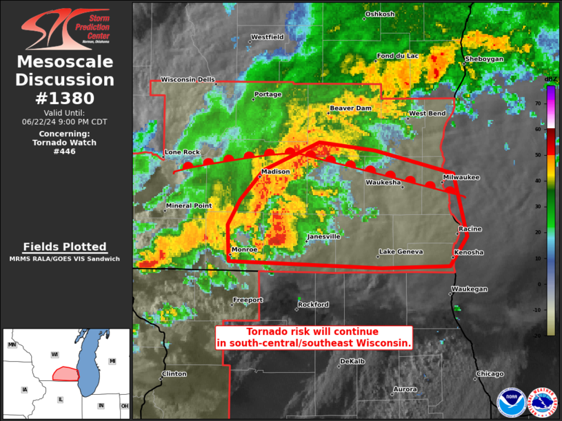
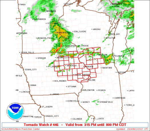
Tornado Watch Number 446
NWS Storm Prediction Center Norman OK
315 PM CDT Sat Jun 22 2024
The NWS Storm Prediction Center has issued a
* Tornado Watch for portions of
Northeast Iowa
Northwest Illinois
Southern Wisconsin
* Effective this Saturday afternoon and evening from 315 PM until
800 PM CDT.
* Primary threats include...
A couple tornadoes possible
Scattered damaging wind gusts to 70 mph likely
Scattered large hail and isolated very large hail events to 2
inches in diameter possible
SUMMARY...Thunderstorms will intensify this afternoon along a
boundary extending from northern Iowa into southern Wisconsin.
Favorable winds aloft will promote supercell storms, capable of
damaging winds, large hail, and perhaps a few tornadoes.
The tornado watch area is approximately along and 55 statute miles
north and south of a line from 40 miles west of Waterloo IA to 30
miles north of Rockford IL. For a complete depiction of the watch
see the associated watch outline update (WOUS64 KWNS WOU6).
PRECAUTIONARY/PREPAREDNESS ACTIONS...
REMEMBER...A Tornado Watch means conditions are favorable for
tornadoes and severe thunderstorms in and close to the watch
area. Persons in these areas should be on the lookout for
threatening weather conditions and listen for later statements
and possible warnings.
&&
AVIATION...Tornadoes and a few severe thunderstorms with hail
surface and aloft to 2 inches. Extreme turbulence and surface wind
gusts to 60 knots. A few cumulonimbi with maximum tops to 500. Mean
storm motion vector 27030.
...Hart
   SEL6

   URGENT - IMMEDIATE BROADCAST REQUESTED
   Tornado Watch Number 446
   NWS Storm Prediction Center Norman OK
   315 PM CDT Sat Jun 22 2024

   The NWS Storm Prediction Center has issued a

   * Tornado Watch for portions of
     Northeast Iowa
     Northwest Illinois
     Southern Wisconsin

   * Effective this Saturday afternoon and evening from 315 PM until
     800 PM CDT.

   * Primary threats include...
     A couple tornadoes possible
     Scattered damaging wind gusts to 70 mph likely
     Scattered large hail and isolated very large hail events to 2
       inches in diameter possible

   SUMMARY...Thunderstorms will intensify this afternoon along a
   boundary extending from northern Iowa into southern Wisconsin.
   Favorable winds aloft will promote supercell storms, capable of
   damaging winds, large hail, and perhaps a few tornadoes.

   The tornado watch area is approximately along and 55 statute miles
   north and south of a line from 40 miles west of Waterloo IA to 30
   miles north of Rockford IL. For a complete depiction of the watch
   see the associated watch outline update (WOUS64 KWNS WOU6).

   PRECAUTIONARY/PREPAREDNESS ACTIONS...

   REMEMBER...A Tornado Watch means conditions are favorable for
   tornadoes and severe thunderstorms in and close to the watch
   area. Persons in these areas should be on the lookout for
   threatening weather conditions and listen for later statements
   and possible warnings.

   &&

   AVIATION...Tornadoes and a few severe thunderstorms with hail
   surface and aloft to 2 inches. Extreme turbulence and surface wind
   gusts to 60 knots. A few cumulonimbi with maximum tops to 500. Mean
   storm motion vector 27030.

   ...Hart
 Note:
The Aviation Watch (SAW) product is an approximation to the watch area.
The actual watch is depicted by the shaded areas.
Note:
The Aviation Watch (SAW) product is an approximation to the watch area.
The actual watch is depicted by the shaded areas.
   SAW6
   WW 446 TORNADO IA IL WI 222015Z - 230100Z
   AXIS..55 STATUTE MILES NORTH AND SOUTH OF LINE..
   40W ALO/WATERLOO IA/ - 30N RFD/ROCKFORD IL/
   ..AVIATION COORDS.. 50NM N/S /33S MCW - 46SW BAE/
   HAIL SURFACE AND ALOFT..2 INCHES. WIND GUSTS..60 KNOTS.
   MAX TOPS TO 500. MEAN STORM MOTION VECTOR 27030.

   LAT...LON 43349319 43438910 41848910 41759319

   THIS IS AN APPROXIMATION TO THE WATCH AREA.  FOR A
   COMPLETE DEPICTION OF THE WATCH SEE WOUS64 KWNS
   FOR WOU6.
Watch 446 Status Report Messages:
STATUS REPORT #2 ON WW 446

VALID 230010Z - 230140Z

SEVERE WEATHER THREAT CONTINUES RIGHT OF A LINE FROM 20 NE DSM TO
25 E ALO TO 45 NNW DBQ TO 30 SW LNR TO 35 N MSN.

..WENDT..06/23/24

ATTN...WFO...ARX...DVN...DMX...MKX...

&&

STATUS REPORT FOR WT 446

SEVERE WEATHER THREAT CONTINUES FOR THE FOLLOWING AREAS

ILC015-085-161-177-195-230140-

IL
.    ILLINOIS COUNTIES INCLUDED ARE

CARROLL 	     JO DAVIESS 	 ROCK ISLAND
STEPHENSON	     WHITESIDE
$$


IAC011-019-031-043-045-055-061-095-097-103-105-113-139-163-171-
230140-

IA
.    IOWA COUNTIES INCLUDED ARE

BENTON		     BUCHANAN		 CEDAR
CLAYTON 	     CLINTON		 DELAWARE
DUBUQUE 	     IOWA		 JACKSON
JOHNSON 	     JONES		 LINN
MUSCATINE	     SCOTT		 TAMA
$$


WIC021-025-027-043-045-049-055-059-065-079-089-101-105-127-131-
133-230140-

WI
.    WISCONSIN COUNTIES INCLUDED ARE

COLUMBIA	     DANE		 DODGE
GRANT		     GREEN		 IOWA
JEFFERSON	     KENOSHA		 LAFAYETTE
MILWAUKEE	     OZAUKEE		 RACINE
ROCK		     WALWORTH		 WASHINGTON
WAUKESHA
$$


THE WATCH STATUS MESSAGE IS FOR GUIDANCE PURPOSES ONLY.  PLEASE
REFER TO WATCH COUNTY NOTIFICATION STATEMENTS FOR OFFICIAL
INFORMATION ON COUNTIES...INDEPENDENT CITIES AND MARINE ZONES
CLEARED FROM SEVERE THUNDERSTORM AND TORNADO WATCHES.
$$

STATUS REPORT #1 ON WW 446

VALID 222140Z - 222240Z

THE SEVERE WEATHER THREAT CONTINUES ACROSS THE ENTIRE WATCH AREA.

..WENDT..06/22/24

ATTN...WFO...ARX...DVN...DMX...MKX...

&&

STATUS REPORT FOR WT 446

SEVERE WEATHER THREAT CONTINUES FOR THE FOLLOWING AREAS

ILC015-085-161-177-195-222240-

IL
.    ILLINOIS COUNTIES INCLUDED ARE

CARROLL 	     JO DAVIESS 	 ROCK ISLAND
STEPHENSON	     WHITESIDE
$$


IAC005-011-013-017-019-023-031-037-043-045-055-061-065-067-069-
075-083-095-097-103-105-113-127-139-163-171-191-222240-

IA
.    IOWA COUNTIES INCLUDED ARE

ALLAMAKEE	     BENTON		 BLACK HAWK
BREMER		     BUCHANAN		 BUTLER
CEDAR		     CHICKASAW		 CLAYTON
CLINTON 	     DELAWARE		 DUBUQUE
FAYETTE 	     FLOYD		 FRANKLIN
GRUNDY		     HARDIN		 IOWA
JACKSON 	     JOHNSON		 JONES
LINN		     MARSHALL		 MUSCATINE
SCOTT		     TAMA		 WINNESHIEK
$$


WIC021-023-025-043-045-049-065-103-105-111-222240-

WI
.    WISCONSIN COUNTIES INCLUDED ARE

COLUMBIA	     CRAWFORD		 DANE
GRANT		     GREEN		 IOWA
LAFAYETTE	     RICHLAND		 ROCK
SAUK
$$


THE WATCH STATUS MESSAGE IS FOR GUIDANCE PURPOSES ONLY.  PLEASE
REFER TO WATCH COUNTY NOTIFICATION STATEMENTS FOR OFFICIAL
INFORMATION ON COUNTIES...INDEPENDENT CITIES AND MARINE ZONES
CLEARED FROM SEVERE THUNDERSTORM AND TORNADO WATCHES.
$$
Note:
Click for Complete Product Text.
Tornadoes
Probability of 2 or more tornadoes
|
Mod (40%)
|
Probability of 1 or more strong (EF2-EF5) tornadoes
|
Low (20%)
|
Wind
Probability of 10 or more severe wind events
|
Mod (60%)
|
Probability of 1 or more wind events > 65 knots
|
Low (20%)
|
Hail
Probability of 10 or more severe hail events
|
Mod (40%)
|
Probability of 1 or more hailstones > 2 inches
|
Mod (30%)
|
Combined Severe Hail/Wind
Probability of 6 or more combined severe hail/wind events
|
High (90%)
|
For each watch, probabilities for particular events inside the watch
(listed above in each table) are determined by the issuing forecaster.
The "Low" category contains probability values ranging from less than 2%
to 20% (EF2-EF5 tornadoes), less than 5% to 20% (all other probabilities),
"Moderate" from 30% to 60%, and "High" from 70% to greater than 95%.
High values are bolded and lighter in color to provide awareness of
an increased threat for a particular event.


 @NWSSPC