|
| Mesoscale Discussion 1389 |
|
< Previous MD Next MD >
|

|
   Mesoscale Discussion 1389
   NWS Storm Prediction Center Norman OK
   0658 PM CDT Sun Jun 23 2024

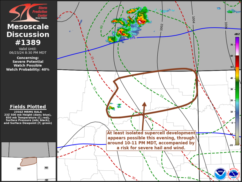
   Areas affected...parts of northeastern Montana

   Concerning...Severe potential...Watch possible

   Valid 232358Z - 240230Z

   Probability of Watch Issuance...40 percent

   SUMMARY...Isolated supercell development appears possible near and
   north of the Missouri River through 8-11 PM MDT.  It is not clear
   that a severe weather watch will be needed due to localized nature
   of the threat, but trends will continue to be monitored.

   DISCUSSION...At least attempts at sustained deep convective
   development appear underway west of Glasgow MT.  This appears near
   the southern edge of the onset of mid-level height falls associated
   with an upstream short wave trough progressing across the Canadian
   and adjacent northern U.S. Rockies.  At lower levels this is focused
   near/east of a weak surface low embedded within lee surface
   troughing, aided by lift associated with low-level convergence and
   warm advection.  Near the northern periphery of a plume of very warm
   elevated mixed-layer air advecting northeast of the northern
   Rockies, the approach of convective temperatures may also be a
   contributing factor.

   Based on various model output, this convective development may be
   maintained into and through the 02-05Z time frame, though it may
   remain isolated in nature to the south of the Saskatchewan border.
   In the presence of strong deep-layer shear, beneath 50+ kt westerly
   flow in the 500-300 mb layer, the environment is supportive of an
   evolving supercell.  A hot and deeply mixed boundary-layer appears
   characterized by CAPE in excess of 1000 J/kg, sufficient to support
   a risk for large hail and locally severe wind gusts.

   ..Kerr/Gleason.. 06/23/2024

   ...Please see www.spc.noaa.gov for graphic product...

   ATTN...WFO...GGW...

   LAT...LON   48690409 48160442 47830699 47950747 48250737 48570708
               48820705 49050447 48690409
|
|
Top/All Mesoscale Discussions/Forecast Products/Home
|
|


