|
| Mesoscale Discussion 1391 |
|
< Previous MD Next MD >
|
|
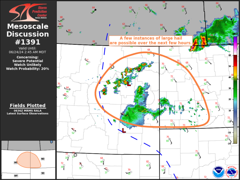
   Mesoscale Discussion 1391
   NWS Storm Prediction Center Norman OK
   0140 AM CDT Mon Jun 24 2024

   Areas affected...Eastern MT...Western North Dakota

   Concerning...Severe potential...Watch unlikely

   Valid 240640Z - 240845Z

   Probability of Watch Issuance...20 percent

   SUMMARY...A few instances of large hail are possible across eastern
   Montana and western North Dakota over the next few hours.

   DISCUSSION...Warm-air advection across a frontal zone across eastern
   MT has contributed to an increase in elevated thunderstorm activity
   over the past hour or so. Significant buoyancy exists downstream
   across far eastern MT and into western ND, supported primarily by
   steep mid-level lapse rates (i.e. 8.5 to 9 deg C per km) and modest
   mid-level moisture. Based on recent mesoanalysis, 0-6 km bulk shear
   is around 40 to 50 kt, with the resulting combination of vertical
   shear and buoyancy supportive of organized updrafts and a few
   elevated supercells. Given the buoyancy downstream, this activity
   may persist for the next few hours into far eastern MT and western
   ND, although the overall coverage may begin to decrease as storms
   become displaced east of the more favorable warm-air advection.
   Large hail is possible within the more organized storms, but the
   overall severe risk should remain isolated, likely precluding the
   need for a watch.

   ..Mosier/Guyer.. 06/24/2024

   ...Please see www.spc.noaa.gov for graphic product...

   ATTN...WFO...BIS...BYZ...GGW...

   LAT...LON   46010390 46130558 46630703 47350750 48330655 48700544
               48760452 48530346 48040242 46870156 46090162 46010390
|
|
Top/All Mesoscale Discussions/Forecast Products/Home
|
|


 @NWSSPC