|
| Mesoscale Discussion 1395 |
|
< Previous MD Next MD >
|
|
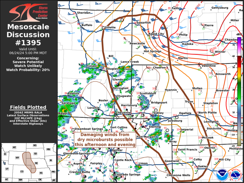
   Mesoscale Discussion 1395
   NWS Storm Prediction Center Norman OK
   0359 PM CDT Mon Jun 24 2024

   Areas affected...Portions of the Central High Plains

   Concerning...Severe potential...Watch unlikely

   Valid 242059Z - 242300Z

   Probability of Watch Issuance...20 percent

   SUMMARY...Thunderstorms capable of isolated damaging winds are
   possible this afternoon and evening over the Central High Plains.

   DISCUSSION...Thunderstorms have developed over the high terrain in
   an environment characterized by large surface T/Td spreads,
   deeply-mixed inverted-v boundary layer profiles, and 25-30 kts of
   deep-layer shear in the southern portion of the MD area, increasing
   to 40-45 kts further north in the Black Hills.

   These storms are expected to continue eastward into the High Plains,
   where buoyancy increases slightly with eastward extent. Given the
   dry environment and weak vertical shear, a few damaging wind gusts
   from dry downdrafts are possible with ongoing convection, and
   additional development may be possible with interacting thunderstorm
   outflows.

   Further north in the Black Hills, convective development is less
   certain, but better combinations of buoyancy and shear indicate
   potential for an isolated hail and damaging wind threat if a storm
   develops out of the current cu field.

   Watch issuance is not likely at this time, but convective trends
   will continue to be monitored.

   ..Halbert/Weinman/Hart.. 06/24/2024

   ...Please see www.spc.noaa.gov for graphic product...

   ATTN...WFO...LBF...DDC...UNR...GLD...BOU...CYS...

   LAT...LON   44890339 44860289 44580245 44260226 43880219 43320214
               42890207 42500192 41960142 41650117 41250090 40860062
               40490042 40090026 39600017 39350027 39070043 38870060
               38730085 38680119 38670161 38670181 38830205 38980218
               39260237 39470253 39680266 39730271 40000320 40260353
               40760405 41200450 41600478 42000499 42300513 42800530
               43460551 43910558 44270551 44540514 44710477 44800434
               44830385 44890339
|
|
Top/All Mesoscale Discussions/Forecast Products/Home
|
|


 @NWSSPC