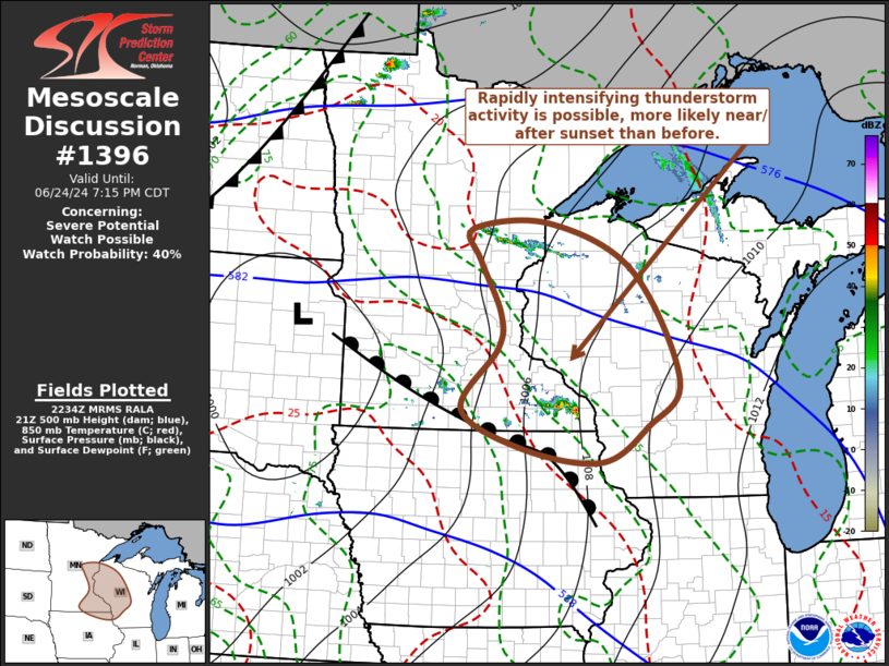
   Mesoscale Discussion 1396
   NWS Storm Prediction Center Norman OK
   0537 PM CDT Mon Jun 24 2024

   Areas affected...east central and southeast Minnesota...western into
   central  Wisconsin and northeastern Iowa

   Concerning...Severe potential...Watch possible

   Valid 242237Z - 250015Z

   CORRECTED FOR AREAS AFFECTED

   Probability of Watch Issuance...40 percent

   SUMMARY...Sustained vigorous thunderstorm development remains
   uncertain, but seems more likely after sunset than before.  Trends
   are being closely monitored, with rapid thunderstorm intensification
   possible, including potential for supercells posing a risk for large
   hail in excess of 2 inches in diameter, locally damaging downbursts
   and a risk for tornadoes.

   DISCUSSION...As a weak mid-level perturbation progresses through
   broader-scale anticyclonic flow across the Upper Midwest/Great Lakes
   region, modest low-level warm advection has become focused
   east-southeast of a surface low over northeastern South Dakota,
   across southern Minnesota and adjacent portions of northeastern
   Iowa/southwestern Wisconsin.  This forcing for ascent appears likely
   to be contributing to the recent thunderstorm initiation near/north
   of the Interstate 90 corridor of southern Minnesota.  The
   boundary-layer is characterized by seasonably high moisture content
   and large CAPE beneath steep mid-level lapse rates, but a plume of
   very warm/dry elevated mixed-layer air is in the process of
   overspreading much of the region, and some further warming
   near/below the 700 mb level may still occur into early evening.

   While it still appears probable that inhibition associated with the
   warm, dry air aloft will tend to suppress this convection, this is
   not entirely certain, and the environment is conditionally
   supportive of intense organized convection give the extreme
   potential instability.  Higher-based ongoing convective development,
   rooted in warm advection closer to the northeastern periphery of the
   elevated mixed-layer air, east-southeast of Brainerd, is also being
   monitored.  As this spreads into northwestern Wisconsin this
   evening, it might undergo considerable further intensification in
   the presence of increasing lift and instability near the nose of a
   strengthening southwesterly low-level jet (30-50 kt around 850 mb).

   ..Kerr/Gleason.. 06/24/2024

   ...Please see www.spc.noaa.gov for graphic product...

   ATTN...WFO...GRB...MKX...DLH...ARX...MPX...DMX...

   LAT...LON   44719324 45239319 46009364 46479382 46569224 45879048
               44248951 43559016 43029111 43229272 43819399 44719324
|


 @NWSSPC