|
| Mesoscale Discussion 1402 |
|
< Previous MD Next MD >
|
|
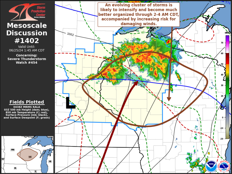
   Mesoscale Discussion 1402
   NWS Storm Prediction Center Norman OK
   1140 PM CDT Mon Jun 24 2024

   Areas affected...parts of east central Minnesota...northwestern into
   central Wisconsin

   Concerning...Severe Thunderstorm Watch 454...

   Valid 250440Z - 250645Z

   The severe weather threat for Severe Thunderstorm Watch 454
   continues.

   SUMMARY...Increasing thunderstorm development seems likely to
   gradually evolve into an intensifying and much better organized
   southeastward moving cluster of storms across northwestern into
   central Wisconsin through 2-4 AM CDT.  This probably will be
   accompanied by increasing risk for damaging wind gusts.  Trends are
   being monitored for the possibility of an additional watch or two
   downstream.

   DISCUSSION...In advance of a surface low now near Minneapolis, it
   appears that the south-southwesterly low-level jet has strengthened
   to 50+ kt across southeastern Minnesota into northwestern Wisconsin.
    Intensifying low-level warm advection and lift have contributed to
   steadily increasing convection in a cluster centered roughly 60
   miles north to northeast of Eau Claire.  Aided by continuing
   elevated updraft inflow of seasonably high moisture content, and
   further erosion of mid-level inhibition, substantive further upscale
   growth of convection appears probable during the next few hours.
   With most unstable CAPE as high as 4000+ J/kg, in the presence of
   moderate to strong deep-layer shear, activity still seems likely to
   eventually become much better organized, including the evolution of
   a notable mesoscale convective vortex.

   With the stronger, unstable inflow being maintained from the south
   to southwest, the evolving cluster seems likely to take on more of a
   southeastward propagation as it becomes better organized across
   central Wisconsin through 07-09Z.  And strengthening rear inflow to
   the west and south of the developing cyclonic circulation may
   gradually be accompanied by increasing risk for damaging surface
   gusts.

   ..Kerr/Gleason.. 06/25/2024

   ...Please see www.spc.noaa.gov for graphic product...

   ATTN...WFO...GRB...DLH...ARX...MPX...

   LAT...LON   45579279 45999206 46179067 45798945 45338852 44618933
               44129053 44189172 44549252 45169348 45579279
|
|
Top/All Mesoscale Discussions/Forecast Products/Home
|
|


 @NWSSPC