Note:
The expiration time in the watch graphic is amended if the watch is
replaced, cancelled or extended.
Note:
Note:
The expiration time in the watch graphic is amended if the watch is
replaced, cancelled or extended.
Note: Click for
Watch Status Reports.
SEL4
URGENT - IMMEDIATE BROADCAST REQUESTED
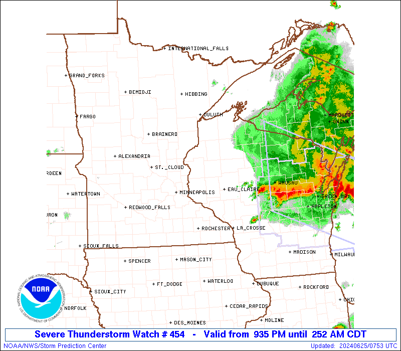
Severe Thunderstorm Watch Number 454
NWS Storm Prediction Center Norman OK
935 PM CDT Mon Jun 24 2024
The NWS Storm Prediction Center has issued a
* Severe Thunderstorm Watch for portions of
Central and Eastern Minnesota
Northwest Wisconsin
Lake Superior
* Effective this Monday night and Tuesday morning from 935 PM
until 400 AM CDT.
* Primary threats include...
Scattered damaging winds likely with isolated significant gusts
to 75 mph possible
Scattered large hail and isolated very large hail events to 2.5
inches in diameter possible
A tornado or two possible
SUMMARY...Thunderstorms are expected to continue increasing in
coverage and intensity this evening and overnight. Initial
supercells will be capable of producing very large hail up to around
2-2.5 inches in diameter. A bowing cluster may eventually develop
and pose more of a severe/damaging wind threat, with gusts
potentially up to 65-75 mph.
The severe thunderstorm watch area is approximately along and 95
statute miles east and west of a line from 110 miles north of Eau
Claire WI to 60 miles southwest of Eau Claire WI. For a complete
depiction of the watch see the associated watch outline update
(WOUS64 KWNS WOU4).
PRECAUTIONARY/PREPAREDNESS ACTIONS...
REMEMBER...A Severe Thunderstorm Watch means conditions are
favorable for severe thunderstorms in and close to the watch area.
Persons in these areas should be on the lookout for threatening
weather conditions and listen for later statements and possible
warnings. Severe thunderstorms can and occasionally do produce
tornadoes.
&&
OTHER WATCH INFORMATION...CONTINUE...WW 452...WW 453...
AVIATION...A few severe thunderstorms with hail surface and aloft to
2.5 inches. Extreme turbulence and surface wind gusts to 65 knots. A
few cumulonimbi with maximum tops to 600. Mean storm motion vector
28035.
...Gleason

SEL4
URGENT - IMMEDIATE BROADCAST REQUESTED
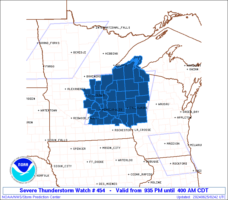
Severe Thunderstorm Watch Number 454
NWS Storm Prediction Center Norman OK
935 PM CDT Mon Jun 24 2024
The NWS Storm Prediction Center has issued a
* Severe Thunderstorm Watch for portions of
Central and Eastern Minnesota
Northwest Wisconsin
Lake Superior
* Effective this Monday night and Tuesday morning from 935 PM
until 400 AM CDT.
* Primary threats include...
Scattered damaging winds likely with isolated significant gusts
to 75 mph possible
Scattered large hail and isolated very large hail events to 2.5
inches in diameter possible
A tornado or two possible
SUMMARY...Thunderstorms are expected to continue increasing in
coverage and intensity this evening and overnight. Initial
supercells will be capable of producing very large hail up to around
2-2.5 inches in diameter. A bowing cluster may eventually develop
and pose more of a severe/damaging wind threat, with gusts
potentially up to 65-75 mph.
The severe thunderstorm watch area is approximately along and 95
statute miles east and west of a line from 110 miles north of Eau
Claire WI to 60 miles southwest of Eau Claire WI. For a complete
depiction of the watch see the associated watch outline update
(WOUS64 KWNS WOU4).
PRECAUTIONARY/PREPAREDNESS ACTIONS...
REMEMBER...A Severe Thunderstorm Watch means conditions are
favorable for severe thunderstorms in and close to the watch area.
Persons in these areas should be on the lookout for threatening
weather conditions and listen for later statements and possible
warnings. Severe thunderstorms can and occasionally do produce
tornadoes.
&&
OTHER WATCH INFORMATION...CONTINUE...WW 452...WW 453...
AVIATION...A few severe thunderstorms with hail surface and aloft to
2.5 inches. Extreme turbulence and surface wind gusts to 65 knots. A
few cumulonimbi with maximum tops to 600. Mean storm motion vector
28035.
...Gleason
 Note:
The Aviation Watch (SAW) product is an approximation to the watch area.
The actual watch is depicted by the shaded areas.
Note:
The Aviation Watch (SAW) product is an approximation to the watch area.
The actual watch is depicted by the shaded areas.
   SAW4
   WW 454 SEVERE TSTM MN WI LS 250235Z - 250900Z
   AXIS..95 STATUTE MILES EAST AND WEST OF LINE..
   110N EAU/EAU CLAIRE WI/ - 60SW EAU/EAU CLAIRE WI/
   ..AVIATION COORDS.. 85NM E/W /36SE DLH - 43WNW ODI/
   HAIL SURFACE AND ALOFT..2.5 INCHES. WIND GUSTS..65 KNOTS.
   MAX TOPS TO 600. MEAN STORM MOTION VECTOR 28035.

   LAT...LON 46448948 44249042 44249426 46449348

   THIS IS AN APPROXIMATION TO THE WATCH AREA.  FOR A
   COMPLETE DEPICTION OF THE WATCH SEE WOUS64 KWNS
   FOR WOU4.
Watch 454 Status Report Messages:
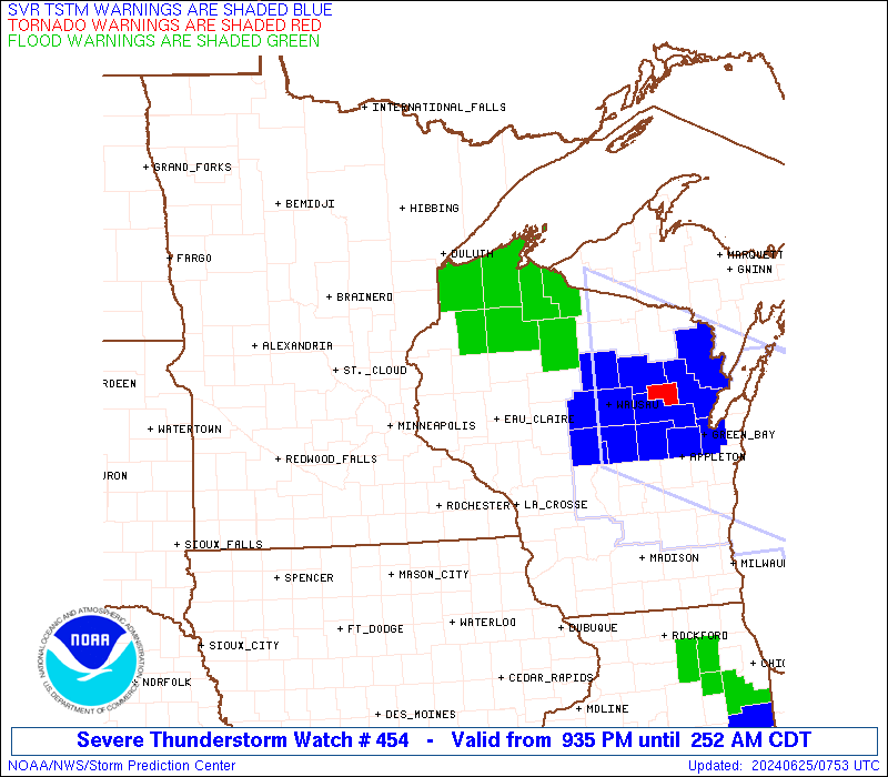
STATUS REPORT #3 ON WW 454

VALID 250620Z - 250740Z

SEVERE WEATHER THREAT CONTINUES RIGHT OF A LINE FROM 25 NNW RST
TO 40 ENE MSP TO 35 N RHI.

..MOSIER..06/25/24

ATTN...WFO...MPX...DLH...ARX...

&&

STATUS REPORT FOR WS 454

SEVERE WEATHER THREAT CONTINUES FOR THE FOLLOWING AREAS

MNC157-250740-

MN
.    MINNESOTA COUNTIES INCLUDED ARE

WABASHA
$$


WIC011-017-019-033-035-053-091-093-099-107-109-119-121-250740-

WI
.    WISCONSIN COUNTIES INCLUDED ARE

BUFFALO 	     CHIPPEWA		 CLARK
DUNN		     EAU CLAIRE 	 JACKSON
PEPIN		     PIERCE		 PRICE
RUSK		     ST. CROIX		 TAYLOR
TREMPEALEAU
$$


THE WATCH STATUS MESSAGE IS FOR GUIDANCE PURPOSES ONLY.  PLEASE
REFER TO WATCH COUNTY NOTIFICATION STATEMENTS FOR OFFICIAL
INFORMATION ON COUNTIES...INDEPENDENT CITIES AND MARINE ZONES
CLEARED FROM SEVERE THUNDERSTORM AND TORNADO WATCHES.
$$

STATUS REPORT #2 ON WW 454

VALID 250445Z - 250540Z

SEVERE WEATHER THREAT CONTINUES RIGHT OF A LINE FROM 15 ESE STC
TO 30 SSE DLH.

..KERR..06/25/24

ATTN...WFO...MPX...DLH...ARX...

&&

STATUS REPORT FOR WS 454

SEVERE WEATHER THREAT CONTINUES FOR THE FOLLOWING AREAS

MNC003-019-025-037-049-053-059-079-123-131-139-141-157-163-171-
250540-

MN
.    MINNESOTA COUNTIES INCLUDED ARE

ANOKA		     CARVER		 CHISAGO
DAKOTA		     GOODHUE		 HENNEPIN
ISANTI		     LE SUEUR		 RAMSEY
RICE		     SCOTT		 SHERBURNE
WABASHA 	     WASHINGTON 	 WRIGHT
$$


WIC003-005-007-011-013-017-019-031-033-035-051-053-091-093-095-
099-107-109-113-119-121-129-250540-

WI
.    WISCONSIN COUNTIES INCLUDED ARE

ASHLAND 	     BARRON		 BAYFIELD
BUFFALO 	     BURNETT		 CHIPPEWA
CLARK		     DOUGLAS		 DUNN
EAU CLAIRE	     IRON		 JACKSON
PEPIN		     PIERCE		 POLK
PRICE		     RUSK		 ST. CROIX
SAWYER		     TAYLOR		 TREMPEALEAU
WASHBURN
$$


LSZ121-145-146-147-148-150-250540-

CW

.    ADJACENT COASTAL WATERS INCLUDED ARE

CHEQUAMEGON BAY-BAYFIELD TO OAK POINT WI

DULUTH MN TO PORT WING WI

PORT WING TO SAND ISLAND WI

SAND ISLAND TO BAYFIELD WI

OAK POINT TO SAXON HARBOR WI

OUTER APOSTLE ISLANDS BEYOND 5 NM FROM MAINLAND

$$
THE WATCH STATUS MESSAGE IS FOR GUIDANCE PURPOSES ONLY.  PLEASE
REFER TO WATCH COUNTY NOTIFICATION STATEMENTS FOR OFFICIAL
INFORMATION ON COUNTIES...INDEPENDENT CITIES AND MARINE ZONES
CLEARED FROM SEVERE THUNDERSTORM AND TORNADO WATCHES.
$$

STATUS REPORT #1 ON WW 454

VALID 250330Z - 250440Z

THE SEVERE WEATHER THREAT CONTINUES ACROSS THE ENTIRE WATCH AREA.

..KERR..06/25/24

ATTN...WFO...MPX...DLH...ARX...

&&

STATUS REPORT FOR WS 454

SEVERE WEATHER THREAT CONTINUES FOR THE FOLLOWING AREAS

MNC003-009-019-025-037-049-053-059-065-079-095-115-123-131-139-
141-157-163-171-250440-

MN
.    MINNESOTA COUNTIES INCLUDED ARE

ANOKA		     BENTON		 CARVER
CHISAGO 	     DAKOTA		 GOODHUE
HENNEPIN	     ISANTI		 KANABEC
LE SUEUR	     MILLE LACS 	 PINE
RAMSEY		     RICE		 SCOTT
SHERBURNE	     WABASHA		 WASHINGTON
WRIGHT
$$


WIC003-005-007-011-013-017-019-031-033-035-051-053-091-093-095-
099-107-109-113-119-121-129-250440-

WI
.    WISCONSIN COUNTIES INCLUDED ARE

ASHLAND 	     BARRON		 BAYFIELD
BUFFALO 	     BURNETT		 CHIPPEWA
CLARK		     DOUGLAS		 DUNN
EAU CLAIRE	     IRON		 JACKSON
PEPIN		     PIERCE		 POLK
PRICE		     RUSK		 ST. CROIX
SAWYER		     TAYLOR		 TREMPEALEAU
WASHBURN
$$


LSZ121-145-146-147-148-150-250440-

CW

.    ADJACENT COASTAL WATERS INCLUDED ARE

CHEQUAMEGON BAY-BAYFIELD TO OAK POINT WI

DULUTH MN TO PORT WING WI

PORT WING TO SAND ISLAND WI

SAND ISLAND TO BAYFIELD WI

OAK POINT TO SAXON HARBOR WI

OUTER APOSTLE ISLANDS BEYOND 5 NM FROM MAINLAND

$$
THE WATCH STATUS MESSAGE IS FOR GUIDANCE PURPOSES ONLY.  PLEASE
REFER TO WATCH COUNTY NOTIFICATION STATEMENTS FOR OFFICIAL
INFORMATION ON COUNTIES...INDEPENDENT CITIES AND MARINE ZONES
CLEARED FROM SEVERE THUNDERSTORM AND TORNADO WATCHES.
$$
Note:
Click for Complete Product Text.
Tornadoes
Probability of 2 or more tornadoes
|
Low (20%)
|
Probability of 1 or more strong (EF2-EF5) tornadoes
|
Low (10%)
|
Wind
Probability of 10 or more severe wind events
|
Mod (60%)
|
Probability of 1 or more wind events > 65 knots
|
Mod (40%)
|
Hail
Probability of 10 or more severe hail events
|
Mod (50%)
|
Probability of 1 or more hailstones > 2 inches
|
Mod (40%)
|
Combined Severe Hail/Wind
Probability of 6 or more combined severe hail/wind events
|
High (80%)
|
For each watch, probabilities for particular events inside the watch
(listed above in each table) are determined by the issuing forecaster.
The "Low" category contains probability values ranging from less than 2%
to 20% (EF2-EF5 tornadoes), less than 5% to 20% (all other probabilities),
"Moderate" from 30% to 60%, and "High" from 70% to greater than 95%.
High values are bolded and lighter in color to provide awareness of
an increased threat for a particular event.


 @NWSSPC