 Note:
The expiration time in the watch graphic is amended if the watch is
replaced, cancelled or extended.
Note:
Note:
The expiration time in the watch graphic is amended if the watch is
replaced, cancelled or extended.
Note: Click for
Watch Status Reports.
SEL5
URGENT - IMMEDIATE BROADCAST REQUESTED
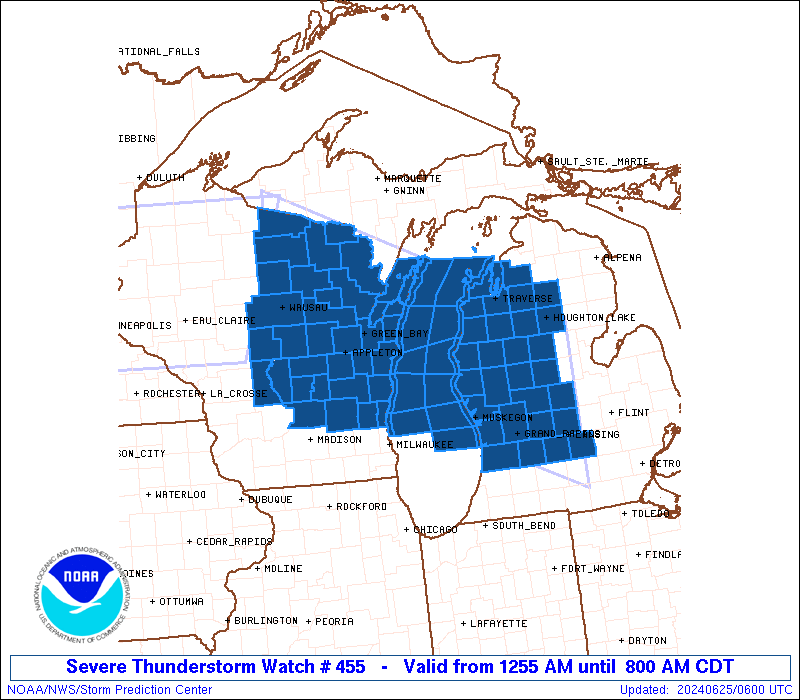
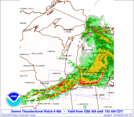
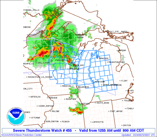
Severe Thunderstorm Watch Number 455
NWS Storm Prediction Center Norman OK
1255 AM CDT Tue Jun 25 2024
The NWS Storm Prediction Center has issued a
* Severe Thunderstorm Watch for portions of
Western and central Lower Michigan
Central and eastern Wisconsin
Lake Michigan
* Effective this Tuesday morning from 1255 AM until 800 AM CDT.
* Primary threats include...
Scattered damaging wind gusts to 70 mph possible
Isolated large hail events to 1.5 inches in diameter possible
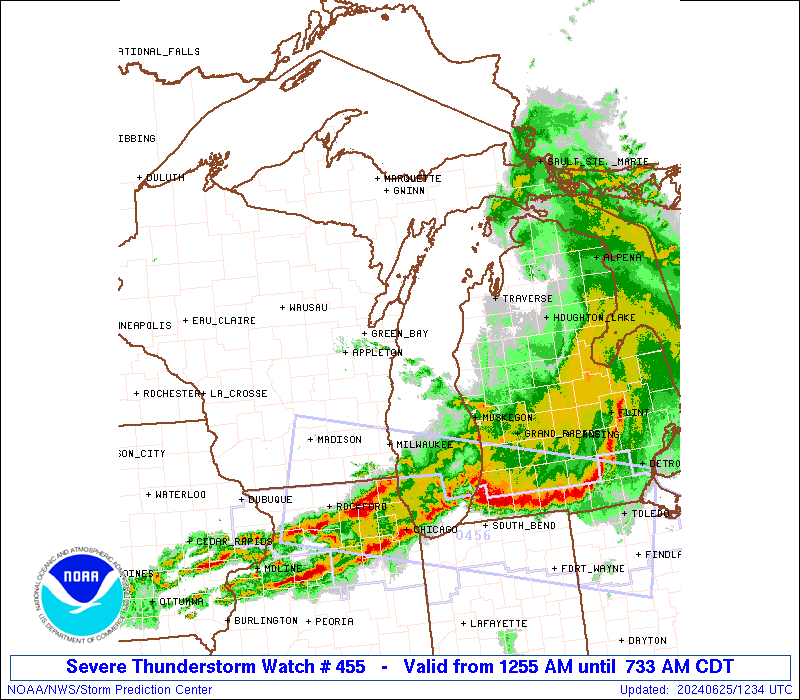
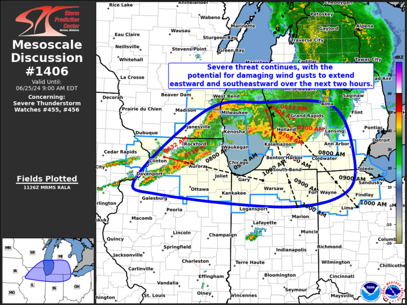
SUMMARY...AN increasingly organized complex of thunderstorms should
move southeastward across the watch area, including central Lake
Michigan, with potential for damaging to severe gusts and occasional
large hail through at least sunrise.
The severe thunderstorm watch area is approximately along and 80
statute miles north and south of a line from 25 miles southwest of
Rhinelander WI to 30 miles north northeast of Lansing MI. For a
complete depiction of the watch see the associated watch outline
update (WOUS64 KWNS WOU5).
PRECAUTIONARY/PREPAREDNESS ACTIONS...
REMEMBER...A Severe Thunderstorm Watch means conditions are
favorable for severe thunderstorms in and close to the watch area.
Persons in these areas should be on the lookout for threatening
weather conditions and listen for later statements and possible
warnings. Severe thunderstorms can and occasionally do produce
tornadoes.
&&
OTHER WATCH INFORMATION...CONTINUE...WW 454...
AVIATION...A few severe thunderstorms with hail surface and aloft to
1.5 inches. Extreme turbulence and surface wind gusts to 60 knots. A
few cumulonimbi with maximum tops to 550. Mean storm motion vector
30035.
...Edwards
   SEL5

   URGENT - IMMEDIATE BROADCAST REQUESTED
   Severe Thunderstorm Watch Number 455
   NWS Storm Prediction Center Norman OK
   1255 AM CDT Tue Jun 25 2024

   The NWS Storm Prediction Center has issued a

   * Severe Thunderstorm Watch for portions of
     Western and central Lower Michigan
     Central and eastern Wisconsin
     Lake Michigan

   * Effective this Tuesday morning from 1255 AM until 800 AM CDT.

   * Primary threats include...
     Scattered damaging wind gusts to 70 mph possible
     Isolated large hail events to 1.5 inches in diameter possible

   SUMMARY...AN increasingly organized complex of thunderstorms should
   move southeastward across the watch area, including central Lake
   Michigan, with potential for damaging to severe gusts and occasional
   large hail through at least sunrise.

   The severe thunderstorm watch area is approximately along and 80
   statute miles north and south of a line from 25 miles southwest of
   Rhinelander WI to 30 miles north northeast of Lansing MI. For a
   complete depiction of the watch see the associated watch outline
   update (WOUS64 KWNS WOU5).

   PRECAUTIONARY/PREPAREDNESS ACTIONS...

   REMEMBER...A Severe Thunderstorm Watch means conditions are
   favorable for severe thunderstorms in and close to the watch area.
   Persons in these areas should be on the lookout for threatening
   weather conditions and listen for later statements and possible
   warnings. Severe thunderstorms can and occasionally do produce
   tornadoes.

   &&

   OTHER WATCH INFORMATION...CONTINUE...WW 454...

   AVIATION...A few severe thunderstorms with hail surface and aloft to
   1.5 inches. Extreme turbulence and surface wind gusts to 60 knots. A
   few cumulonimbi with maximum tops to 550. Mean storm motion vector
   30035.

   ...Edwards
 Note:
The Aviation Watch (SAW) product is an approximation to the watch area.
The actual watch is depicted by the shaded areas.
Note:
The Aviation Watch (SAW) product is an approximation to the watch area.
The actual watch is depicted by the shaded areas.
   SAW5
   WW 455 SEVERE TSTM MI WI LM 250555Z - 251300Z
   AXIS..80 STATUTE MILES NORTH AND SOUTH OF LINE..
   25SW RHI/RHINELANDER WI/ - 30NNE LAN/LANSING MI/
   ..AVIATION COORDS.. 70NM N/S /22SW RHI - 24SSW MBS/
   HAIL SURFACE AND ALOFT..1.5 INCHES. WIND GUSTS..60 KNOTS.
   MAX TOPS TO 550. MEAN STORM MOTION VECTOR 30035.

   LAT...LON 46538983 44348435 42028435 44228983

   THIS IS AN APPROXIMATION TO THE WATCH AREA.  FOR A
   COMPLETE DEPICTION OF THE WATCH SEE WOUS64 KWNS
   FOR WOU5.
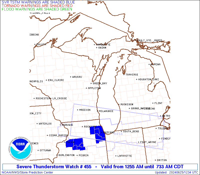
Watch 455 Status Report Messages:
STATUS REPORT #2 ON WW 455

VALID 251015Z - 251140Z

SEVERE WEATHER THREAT CONTINUES RIGHT OF A LINE FROM 20 WSW OSH
TO 45 ESE MTW TO 25 NNW MBS.

FOR ADDITIONAL INFORMATION SEE MESOSCALE DISCUSSION 1404

..MOSIER..06/25/24

ATTN...WFO...GRR...APX...ARX...GRB...MKX...

&&

STATUS REPORT FOR WS 455

SEVERE WEATHER THREAT CONTINUES FOR THE FOLLOWING AREAS

MIC005-015-025-037-045-057-065-067-073-075-077-081-107-117-121-
123-127-139-159-251140-

MI
.    MICHIGAN COUNTIES INCLUDED ARE

ALLEGAN 	     BARRY		 CALHOUN
CLINTON 	     EATON		 GRATIOT
INGHAM		     IONIA		 ISABELLA
JACKSON 	     KALAMAZOO		 KENT
MECOSTA 	     MONTCALM		 MUSKEGON
NEWAYGO 	     OCEANA		 OTTAWA
VAN BUREN
$$


WIC027-039-089-117-131-251140-

WI
.    WISCONSIN COUNTIES INCLUDED ARE

DODGE		     FOND DU LAC	 OZAUKEE
SHEBOYGAN	     WASHINGTON
$$


LMZ643-644-669-671-844-845-846-847-848-870-872-874-876-878-
251140-

CW

.    ADJACENT COASTAL WATERS INCLUDED ARE

SHEBOYGAN TO PORT WASHINGTON WI

PORT WASHINGTON TO NORTH POINT LIGHT WI

LAKE MICHIGAN FROM SHEBOYGAN TO PORT WASHINGTON WI 5NM OFFSHORE
TO MID LAKE

LAKE MICHIGAN FROM PORT WASHINGTON TO NORTH POINT LIGHT WI 5NM
OFFSHORE TO MID LAKE

ST JOSEPH TO SOUTH HAVEN MI

SOUTH HAVEN TO HOLLAND MI

HOLLAND TO GRAND HAVEN MI

GRAND HAVEN TO WHITEHALL MI

WHITEHALL TO PENTWATER MI

LAKE MICHIGAN FROM WHITEHALL TO PENTWATER MI 5NM OFFSHORE TO MID
LAKE

LAKE MICHIGAN FROM GRAND HAVEN TO WHITEHALL MI 5NM OFFSHORE TO
MID LAKE

LAKE MICHIGAN FROM HOLLAND TO GRAND HAVEN MI 5NM OFFSHORE TO MID
LAKE

LAKE MICHIGAN FROM SOUTH HAVEN TO HOLLAND MI 5NM OFFSHORE TO MID
LAKE

LAKE MICHIGAN FROM ST JOSEPH TO SOUTH HAVEN MI 5NM OFFSHORE TO
MID LAKE

$$
THE WATCH STATUS MESSAGE IS FOR GUIDANCE PURPOSES ONLY.  PLEASE
REFER TO WATCH COUNTY NOTIFICATION STATEMENTS FOR OFFICIAL
INFORMATION ON COUNTIES...INDEPENDENT CITIES AND MARINE ZONES
CLEARED FROM SEVERE THUNDERSTORM AND TORNADO WATCHES.
$$

STATUS REPORT #1 ON WW 455

VALID 250820Z - 250940Z

SEVERE WEATHER THREAT CONTINUES RIGHT OF A LINE FROM 10 WNW CWA
TO 15 N GRB TO 15 S ESC.

..MOSIER..06/25/24

ATTN...WFO...GRR...APX...ARX...GRB...MKX...

&&

STATUS REPORT FOR WS 455

SEVERE WEATHER THREAT CONTINUES FOR THE FOLLOWING AREAS

MIC005-009-015-019-035-037-039-045-055-057-065-067-073-079-081-
085-089-101-105-107-113-117-121-123-127-133-139-143-165-
250940-

MI
.    MICHIGAN COUNTIES INCLUDED ARE

ALLEGAN 	     ANTRIM		 BARRY
BENZIE		     CLARE		 CLINTON
CRAWFORD	     EATON		 GRAND TRAVERSE
GRATIOT 	     INGHAM		 IONIA
ISABELLA	     KALKASKA		 KENT
LAKE		     LEELANAU		 MANISTEE
MASON		     MECOSTA		 MISSAUKEE
MONTCALM	     MUSKEGON		 NEWAYGO
OCEANA		     OSCEOLA		 OTTAWA
ROSCOMMON	     WEXFORD
$$


WIC001-009-015-021-027-029-039-047-057-061-071-077-087-089-097-
115-117-131-135-137-139-141-250940-

WI
.    WISCONSIN COUNTIES INCLUDED ARE

ADAMS		     BROWN		 CALUMET
COLUMBIA	     DODGE		 DOOR
FOND DU LAC	     GREEN LAKE 	 JUNEAU
KEWAUNEE	     MANITOWOC		 MARQUETTE
OUTAGAMIE	     OZAUKEE		 PORTAGE
SHAWANO 	     SHEBOYGAN		 WASHINGTON
WAUPACA 	     WAUSHARA		 WINNEBAGO
WOOD
$$


LMZ323-344-345-346-364-366-521-522-541-542-543-563-565-567-643-
644-669-671-846-847-848-849-868-870-872-874-250940-

CW

.    ADJACENT COASTAL WATERS INCLUDED ARE

GRAND TRAVERSE BAY SOUTH OF A LINE GRAND TRAVERSE LIGHT TO
NORWOOD MI

SLEEPING BEAR POINT TO GRAND TRAVERSE LIGHT MI

POINT BETSIE TO SLEEPING BEAR POINT MI

MANISTEE TO POINT BETSIE MI

LAKE MICHIGAN FROM CHARLEVOIX TO POINT BETSIE MI 5NM OFFSHORE TO
MID LAKE

LAKE MICHIGAN FROM POINT BETSIE TO MANISTEE MI 5NM OFFSHORE TO
MID LAKE

GREEN BAY SOUTH OF LINE FROM  CEDAR RIVER TO ROCK ISLAND PASSAGE
AND NORTH OF A LINE FROM OCONTO WI TO LITTLE STURGEON BAY WI

GREEN BAY SOUTH OF LINE FROM  OCONTO WI TO LITTLE STURGEON BAY WI

ROCK ISLAND PASSAGE TO STURGEON BAY WI

STURGEON BAY TO TWO RIVERS WI

TWO RIVERS TO SHEBOYGAN WI

LAKE MICHIGAN FROM ROCK ISLAND PASSAGE TO STURGEON BAY WI 5NM
OFFSHORE TO MID LAKE

LAKE MICHIGAN FROM STURGEON BAY TO TWO RIVERS WI 5NM OFFSHORE TO
MID LAKE

LAKE MICHIGAN FROM TWO RIVERS TO SHEBOYGAN WI 5NM OFFSHORE TO MID
LAKE

SHEBOYGAN TO PORT WASHINGTON WI

PORT WASHINGTON TO NORTH POINT LIGHT WI

LAKE MICHIGAN FROM SHEBOYGAN TO PORT WASHINGTON WI 5NM OFFSHORE
TO MID LAKE

LAKE MICHIGAN FROM PORT WASHINGTON TO NORTH POINT LIGHT WI 5NM
OFFSHORE TO MID LAKE

HOLLAND TO GRAND HAVEN MI

GRAND HAVEN TO WHITEHALL MI

WHITEHALL TO PENTWATER MI

PENTWATER TO MANISTEE MI

LAKE MICHIGAN FROM PENTWATER TO MANISTEE MI 5NM OFFSHORE TO MID
LAKE

LAKE MICHIGAN FROM WHITEHALL TO PENTWATER MI 5NM OFFSHORE TO MID
LAKE

LAKE MICHIGAN FROM GRAND HAVEN TO WHITEHALL MI 5NM OFFSHORE TO
MID LAKE

LAKE MICHIGAN FROM HOLLAND TO GRAND HAVEN MI 5NM OFFSHORE TO MID
LAKE

$$
THE WATCH STATUS MESSAGE IS FOR GUIDANCE PURPOSES ONLY.  PLEASE
REFER TO WATCH COUNTY NOTIFICATION STATEMENTS FOR OFFICIAL
INFORMATION ON COUNTIES...INDEPENDENT CITIES AND MARINE ZONES
CLEARED FROM SEVERE THUNDERSTORM AND TORNADO WATCHES.
$$
Note:
Click for Complete Product Text.
Tornadoes
Probability of 2 or more tornadoes
|
Low (10%)
|
Probability of 1 or more strong (EF2-EF5) tornadoes
|
Low (<2%)
|
Wind
Probability of 10 or more severe wind events
|
Mod (40%)
|
Probability of 1 or more wind events > 65 knots
|
Low (10%)
|
Hail
Probability of 10 or more severe hail events
|
Mod (30%)
|
Probability of 1 or more hailstones > 2 inches
|
Low (20%)
|
Combined Severe Hail/Wind
Probability of 6 or more combined severe hail/wind events
|
High (80%)
|
For each watch, probabilities for particular events inside the watch
(listed above in each table) are determined by the issuing forecaster.
The "Low" category contains probability values ranging from less than 2%
to 20% (EF2-EF5 tornadoes), less than 5% to 20% (all other probabilities),
"Moderate" from 30% to 60%, and "High" from 70% to greater than 95%.
High values are bolded and lighter in color to provide awareness of
an increased threat for a particular event.


 @NWSSPC