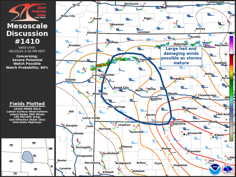
   Mesoscale Discussion 1410
   NWS Storm Prediction Center Norman OK
   0236 PM CDT Tue Jun 25 2024

   Areas affected...Western South Dakota

   Concerning...Severe potential...Watch possible

   Valid 251936Z - 252130Z

   Probability of Watch Issuance...60 percent

   SUMMARY...Thunderstorm development is ongoing in northwestern South
   Dakota and over the Black Hills. These storms will be capable of
   damaging winds and large hail, especially with southeastward extent.
   Convective trends are being monitored, and weather watch issuance
   may be needed later this afternoon and evening.

   DISCUSSION...Thunderstorm development is increasing in coverage
   along a cold front that is slowly moving south across northern South
   Dakota, with additional development possible over the Black Hills.
   SPC Mesoanalysis shows these storms are in an environment
   characterized by 1500 J/kg of MLCAPE and 45-50 kts of deep layer
   shear, though in a relatively dry boundary layer with large T/Td
   spreads.

   Given the strong vertical shear and deep, dry boundary layer, these
   storms will be capable of damaging wind gusts, especially with any
   organized bowing segments and embedded supercells. Large hail may be
   possible with any rotating convection as storms move further south
   and east into richer boundary layer moisture and buoyancy.

   In the Black Hills, surface observations and RAP sounding profiles
   indicate locally higher moisture content with lower LCL heights and
   better buoyancy, with 45-50 kts of deep layer shear characterized by
   long, straight hodographs. If convective initiation occurs over the
   Black Hills, as is expected, splitting supercells capable of large
   hail and damaging winds will be possible.

   Convective trends are being monitored for a weather watch, though
   uncertainty exists on exact timing and southeastward extent of watch
   issuance.

   ..Halbert/Weinman/Hart.. 06/25/2024

   ...Please see www.spc.noaa.gov for graphic product...

   ATTN...WFO...ABR...LBF...UNR...

   LAT...LON   45250302 45290259 45290225 45250190 45070156 44870128
               44590106 44200090 44010077 43750068 43460059 43140054
               42930070 42910108 42940174 43040215 43170255 43380303
               43500323 43620353 43840377 44230374 44570362 44850347
               45180324 45250302
|


 @NWSSPC