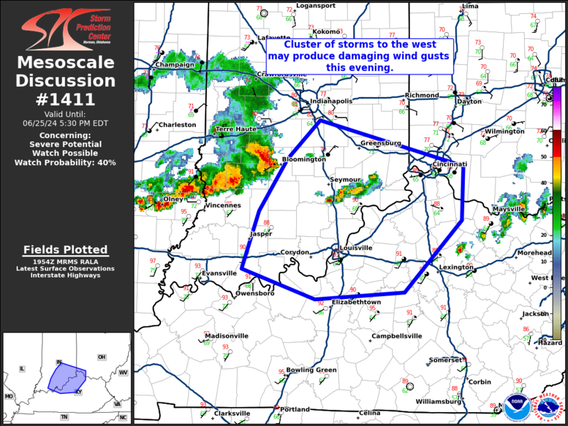
   Mesoscale Discussion 1411
   NWS Storm Prediction Center Norman OK
   0257 PM CDT Tue Jun 25 2024

   Areas affected...southern Indiana...far southwest Ohio...and
   northern Kentucky

   Concerning...Severe potential...Watch possible

   Valid 251957Z - 252130Z

   Probability of Watch Issuance...40 percent

   SUMMARY...A cluster of storms across western Indiana may produce
   some damaging wind gusts across eastern Indiana, northern Kentucky,
   and far southwest Ohio this evening.

   DISCUSSION...The airmass ahead of a storm cluster in western Indiana
   continues to destabilize with SPC mesoanalysis suggesting an
   uncapped warm sector. As long as the airmass ahead of this cluster
   continues to destabilize, at least some damaging wind threat is
   expected to persist. Therefore, a severe thunderstorm watch may be
   needed across southeast Indiana, northern Kentucky, and southwest
   Ohio.

   However, uncertainties remain. The outflow boundary from the morning
   continues to move south and it is possible this will undercut the
   storms which could weaken them. Visible satellite and the KIND
   WSR-88D also show a showing trend of this outflow boundary slowing
   over the past hour. Therefore, this boundary may provide the focused
   corridor for the threat.

   Additionally, some storms have developed along this boundary in
   southeast Indiana. This is east of the greatest instability and
   thus, these storms will likely remain below severe limits.

   Trends of upstream convection and development along the outflow
   boundary will be monitored for a potential downstream watch.

   ..Bentley/Hart.. 06/25/2024

   ...Please see www.spc.noaa.gov for graphic product...

   ATTN...WFO...ILN...LMK...IND...PAH...

   LAT...LON   38078701 38678680 39228642 39628600 39148410 38588413
               37838489 37778605 38078701
|


 @NWSSPC