|
| Mesoscale Discussion 1421 |
|
< Previous MD Next MD >
|
|
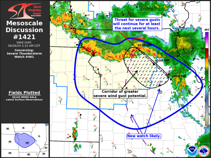
   Mesoscale Discussion 1421
   NWS Storm Prediction Center Norman OK
   0117 AM CDT Wed Jun 26 2024

   Areas affected...Northeast KS...Northern/Central MO

   Concerning...Severe Thunderstorm Watch 461...

   Valid 260617Z - 260815Z

   The severe weather threat for Severe Thunderstorm Watch 461
   continues.

   SUMMARY...Ongoing convective line will continue pose a risk for
   damaging gusts, particularly across north-central into central
   Missouri. A watch will also be needed downstream across central and
   southern Missouri.

   DISCUSSION...Regional radar imagery shows a southward/southeastward
   progressing convective line extending from northeast KS/northwest MO
   border intersection vicinity eastward into north-central MO. In
   particular, the easternmost extent of this line has shown a notable
   increase in southeastward motion over the past hour or so, with
   storm motion now estimated between 45 and 50 kt. This is the same
   portion of the line that produced a 51 kt gust at KLWD (in Decatur
   County IA). These factors, combined with radar velocity data,
   indicate the presence of a rear-inflow jet.

   Surface observations reveal an outflow boundary from prior
   convective that arcs from Linn County MO (just ahead of the bowing
   portion of the line) southward to Hickory County MO (50 miles north
   of SGF) and back more southeastward through south-central MO. This
   boundary could provide a favored corridor for storm progression
   later, while also contributing to a greater potential for severe
   gusts. The most favored corridor for severe gusts over the next hour
   exists from Carroll and Chariton Counties southeastward to Callaway
   County.

   Current storm motion take the line to the edge of Severe
   Thunderstorm Watch 461 around 07Z, perhaps sooner if the line
   continues to accelerate. The severe potential will likely extend
   past this time, and a new watch will be needed downstream.

   ..Mosier/Edwards.. 06/26/2024

   ...Please see www.spc.noaa.gov for graphic product...

   ATTN...WFO...LSX...SGF...EAX...OAX...TOP...

   LAT...LON   40249538 40129401 40319331 39879200 38709048 37429300
               38159486 38829561 40249538
|
|
Top/All Mesoscale Discussions/Forecast Products/Home
|
|


 @NWSSPC