|
| Mesoscale Discussion 1434 |
|
< Previous MD Next MD >
|
|
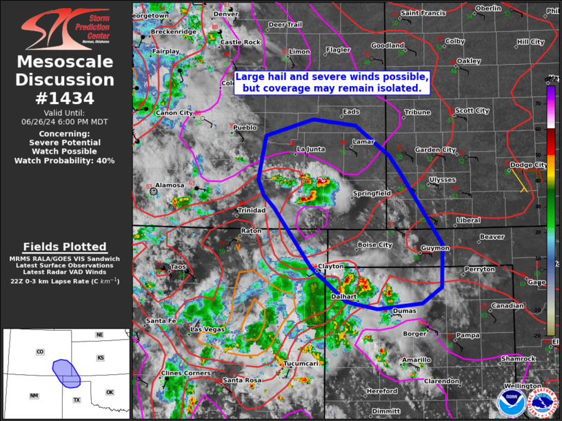
   Mesoscale Discussion 1434
   NWS Storm Prediction Center Norman OK
   0529 PM CDT Wed Jun 26 2024

   Areas affected...Southeast Colorado into northern Texas
   Panhandle..Oklahoma Panhandle...far southwest Kansas

   Concerning...Severe potential...Watch possible

   Valid 262229Z - 270000Z

   Probability of Watch Issuance...40 percent

   SUMMARY...Though coverage may remain isolated, the strongest storms
   will be capable of large hail and severe winds. Trends will be
   monitored for a possible watch late this afternoon.

   DISCUSSION...Moist upslope flow into the Raton Mesa and nearby
   vicinity has led to a cluster storms within parts of the
   Texas/Oklahoma Panhandle as well as more isolated development in
   southeastern Colorado. Modest westerly mid-level winds within the
   upper-level ridge atop easterly/southeasterly surface winds have
   promoted modest effective shear of around 30-35 kts. Given weak
   forcing, storm organization my remain relatively brief/sporadic and
   coverage of severe storms may remain isolated. The strongest storms
   will be capable of large hail and severe winds. It is possible that
   a more organized wind threat could materialize if storms can
   cluster. A northward moving boundary in southeast Colorado could
   provide a focus for this. A watch is possible, but with coverage
   being uncertain, convective trends will continue to be monitored
   late this afternoon.

   ..Wendt/Smith.. 06/26/2024

   ...Please see www.spc.noaa.gov for graphic product...

   ATTN...WFO...DDC...AMA...PUB...ABQ...

   LAT...LON   37280389 37440405 37640415 38220402 38440324 38350254
               37960199 37740182 36790112 36220114 36020146 35950219
               36040271 36490327 37280389
|
|
Top/All Mesoscale Discussions/Forecast Products/Home
|
|


 @NWSSPC