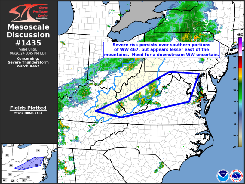
   Mesoscale Discussion 1435
   NWS Storm Prediction Center Norman OK
   0543 PM CDT Wed Jun 26 2024

   Areas affected...eastern Kentucky across West Virginia into parts of
   Maryland and Virginia

   Concerning...Severe Thunderstorm Watch 467...

   Valid 262243Z - 270045Z

   The severe weather threat for Severe Thunderstorm Watch 467
   continues.

   SUMMARY...Local severe risk continues across southern portions of WW
   467, though weaker instability farther east casts some uncertainty
   on the potential need for a downstream watch across northern and
   western Virginia/Maryland.

   DISCUSSION...Latest radar loop shows generally
   disorganized/sub-severe convection ongoing across eastern Kentucky
   and southern/eastern West Virginia at this time, east of the
   advancing cold front.  Local risk for gusty/damaging winds remains,
   with the strongest cells, but overall severe potential should
   continue to gradually diminish this evening.

   Farther east, a less unstable airmass is indicated, per RAP-based
   objective analysis.  As such, storm intensity is not expected to
   increase substantially.  Additionally, modest flow aloft up to
   roughly 3 to 4 KM AGL also suggests limited potential for
   severe-caliber gusts.  However, with that said, temperatures well
   into the 90s across the area are indicative of a deeply mixed
   boundary layer, suggestive that some evaporative cooling potential
   exists -- enhancing the risk for strong outflow winds locally.  At
   this time, WW issuance appears unlikely to be needed, though if the
   aforementioned outflow potential could result in organized cold pool
   growth/expansion, greater wind risk in that scenario could require
   reconsideration of the need for a WW.

   ..Goss.. 06/26/2024

   ...Please see www.spc.noaa.gov for graphic product...

   ATTN...WFO...AKQ...LWX...RNK...PBZ...RLX...MRX...JKL...

   LAT...LON   37278409 38198180 39287951 39677856 39537632 37897713
               37577911 36968216 37278409
|


 @NWSSPC