|
| Mesoscale Discussion 1529 |
|
< Previous MD Next MD >
|
|
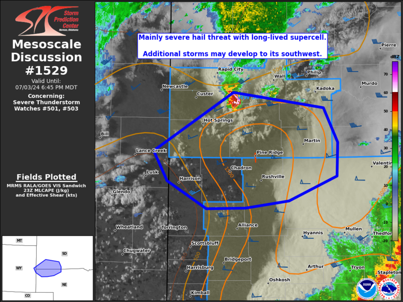
   Mesoscale Discussion 1529
   NWS Storm Prediction Center Norman OK
   0616 PM CDT Wed Jul 03 2024

   Areas affected...Southwest SD and northwest NE

   Concerning...Severe Thunderstorm Watch 501...503...

   Valid 032316Z - 040045Z

   The severe weather threat for Severe Thunderstorm Watch 501, 503
   continues.

   SUMMARY...A long-lived supercell may continue to produce large hail
   as it moves east-southeast in southwest South Dakota. Additional
   higher-based storms may develop to its southwest in northwest
   Nebraska, yielding a severe threat beyond the 01Z expiration of WW
   501.

   DISCUSSION...A long-lived supercell has tracked across a part of the
   Black Hills with several reported severe hail events, most recently
   up to around 1.5 inches in diameter. Per UDX radar, this cell is
   riding immediately behind the composite outflow/front moving
   southeast in southwest SD. The trailing portion of this boundary
   will impinge on a pocket of residual buoyancy that was not
   overturned by the QLCS in north-central to southwest NE. Recent HRRR
   guidance has been insistent on additional development through dusk,
   which would likely yield potential for a supercell or two into
   northwest NE after the 01Z scheduled expiration of WW 501. This
   threat should be short-lived however, given the extensive nature of
   the QLCS to the southeast and eventual inflow of overturned air as
   it advects northwestward this evening.

   ..Grams.. 07/03/2024

   ...Please see www.spc.noaa.gov for graphic product...

   ATTN...WFO...LBF...UNR...CYS...

   LAT...LON   43820293 43620136 43180112 42750114 42440198 42350272
               42350339 42700407 43070432 43820293
|
|
Top/All Mesoscale Discussions/Forecast Products/Home
|
|


 @NWSSPC