 Note:
The expiration time in the watch graphic is amended if the watch is
replaced, cancelled or extended.
Note:
Note:
The expiration time in the watch graphic is amended if the watch is
replaced, cancelled or extended.
Note: Click for
Watch Status Reports.
SEL3
URGENT - IMMEDIATE BROADCAST REQUESTED
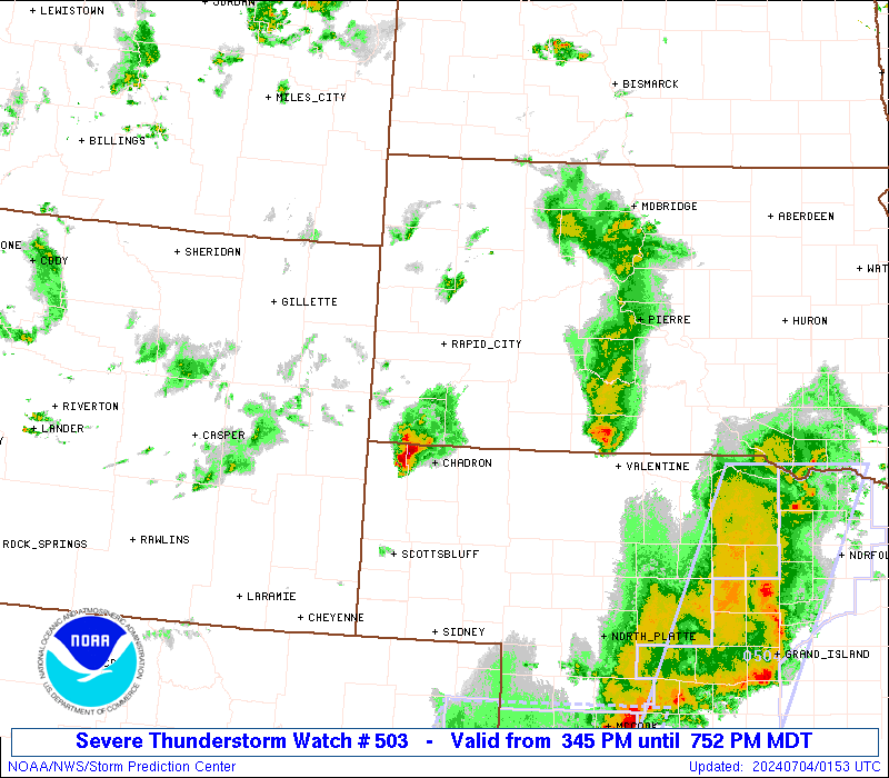
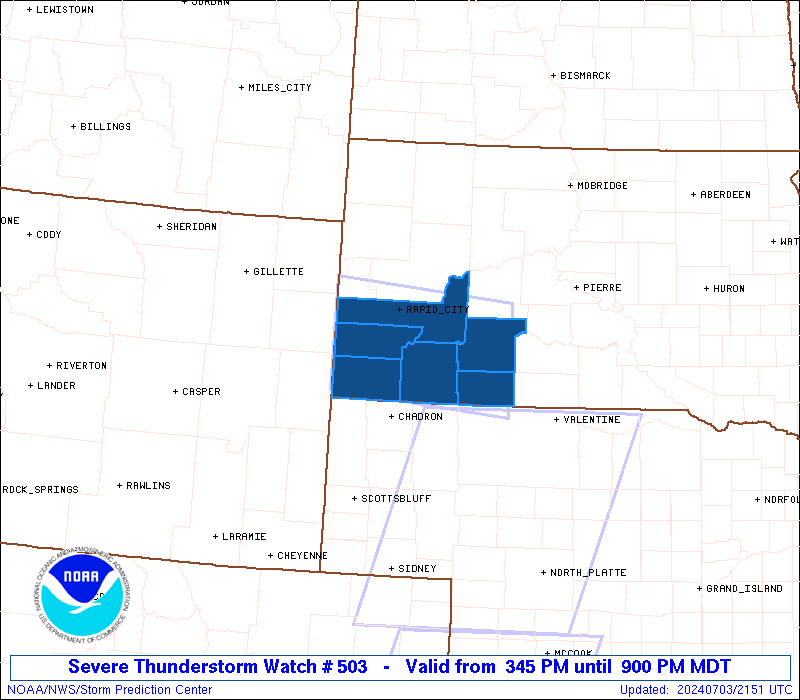
Severe Thunderstorm Watch Number 503
NWS Storm Prediction Center Norman OK
345 PM MDT Wed Jul 3 2024
The NWS Storm Prediction Center has issued a
* Severe Thunderstorm Watch for portions of
Southwest South Dakota
* Effective this Wednesday afternoon and evening from 345 PM
until 900 PM MDT.
* Primary threats include...
Scattered large hail and isolated very large hail events to 2
inches in diameter possible
Scattered damaging wind gusts to 70 mph possible
A tornado or two possible
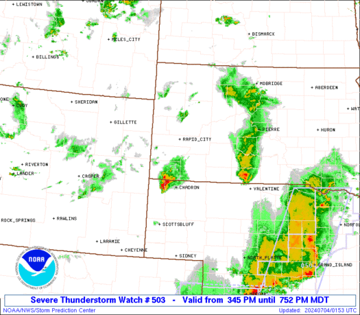
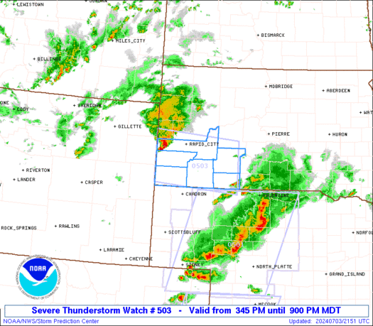
SUMMARY...A cluster of thunderstorms west of the Black Hills will
track east-southeastward across the watch area through the early
evening, posing a risk of damaging winds and large hail.
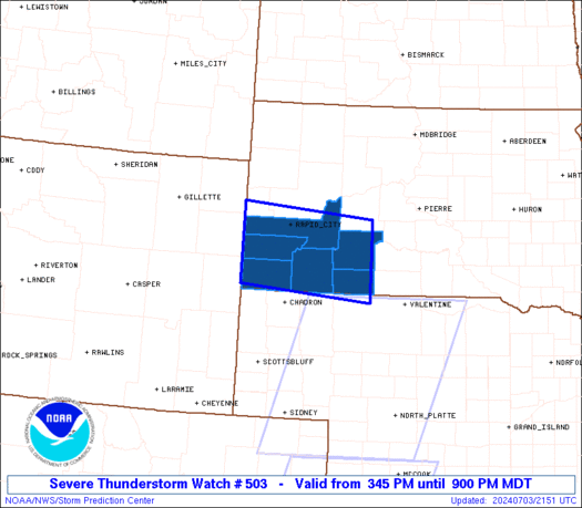
The severe thunderstorm watch area is approximately along and 45
statute miles north and south of a line from 55 miles west southwest
of Rapid City SD to 40 miles south southeast of Philip SD. For a
complete depiction of the watch see the associated watch outline
update (WOUS64 KWNS WOU3).
PRECAUTIONARY/PREPAREDNESS ACTIONS...
REMEMBER...A Severe Thunderstorm Watch means conditions are
favorable for severe thunderstorms in and close to the watch area.
Persons in these areas should be on the lookout for threatening
weather conditions and listen for later statements and possible
warnings. Severe thunderstorms can and occasionally do produce
tornadoes.
&&
OTHER WATCH INFORMATION...CONTINUE...WW 501...WW 502...
AVIATION...A few severe thunderstorms with hail surface and aloft to
2 inches. Extreme turbulence and surface wind gusts to 60 knots. A
few cumulonimbi with maximum tops to 500. Mean storm motion vector
28030.
...Hart
   SEL3

   URGENT - IMMEDIATE BROADCAST REQUESTED
   Severe Thunderstorm Watch Number 503
   NWS Storm Prediction Center Norman OK
   345 PM MDT Wed Jul 3 2024

   The NWS Storm Prediction Center has issued a

   * Severe Thunderstorm Watch for portions of
     Southwest South Dakota

   * Effective this Wednesday afternoon and evening from 345 PM
     until 900 PM MDT.

   * Primary threats include...
     Scattered large hail and isolated very large hail events to 2
       inches in diameter possible
     Scattered damaging wind gusts to 70 mph possible
     A tornado or two possible

   SUMMARY...A cluster of thunderstorms west of the Black Hills will
   track east-southeastward across the watch area through the early
   evening, posing a risk of damaging winds and large hail.

   The severe thunderstorm watch area is approximately along and 45
   statute miles north and south of a line from 55 miles west southwest
   of Rapid City SD to 40 miles south southeast of Philip SD. For a
   complete depiction of the watch see the associated watch outline
   update (WOUS64 KWNS WOU3).

   PRECAUTIONARY/PREPAREDNESS ACTIONS...

   REMEMBER...A Severe Thunderstorm Watch means conditions are
   favorable for severe thunderstorms in and close to the watch area.
   Persons in these areas should be on the lookout for threatening
   weather conditions and listen for later statements and possible
   warnings. Severe thunderstorms can and occasionally do produce
   tornadoes.

   &&

   OTHER WATCH INFORMATION...CONTINUE...WW 501...WW 502...

   AVIATION...A few severe thunderstorms with hail surface and aloft to
   2 inches. Extreme turbulence and surface wind gusts to 60 knots. A
   few cumulonimbi with maximum tops to 500. Mean storm motion vector
   28030.

   ...Hart
 Note:
The Aviation Watch (SAW) product is an approximation to the watch area.
The actual watch is depicted by the shaded areas.
Note:
The Aviation Watch (SAW) product is an approximation to the watch area.
The actual watch is depicted by the shaded areas.
   SAW3
   WW 503 SEVERE TSTM SD 032145Z - 040300Z
   AXIS..45 STATUTE MILES NORTH AND SOUTH OF LINE..
   55WSW RAP/RAPID CITY SD/ - 40SSE PHP/PHILIP SD/
   ..AVIATION COORDS.. 40NM N/S /48WSW RAP - 72SW PIR/
   HAIL SURFACE AND ALOFT..2 INCHES. WIND GUSTS..60 KNOTS.
   MAX TOPS TO 500. MEAN STORM MOTION VECTOR 28030.

   LAT...LON 44390407 44170129 42860129 43090407

   THIS IS AN APPROXIMATION TO THE WATCH AREA.  FOR A
   COMPLETE DEPICTION OF THE WATCH SEE WOUS64 KWNS
   FOR WOU3.
Watch 503 Status Report Messages:
STATUS REPORT #2 ON WW 503
VALID 032335Z - 040040Z
SEVERE WEATHER THREAT CONTINUES RIGHT OF A LINE FROM 65 ENE DGW
TO 30 NNW PHP.
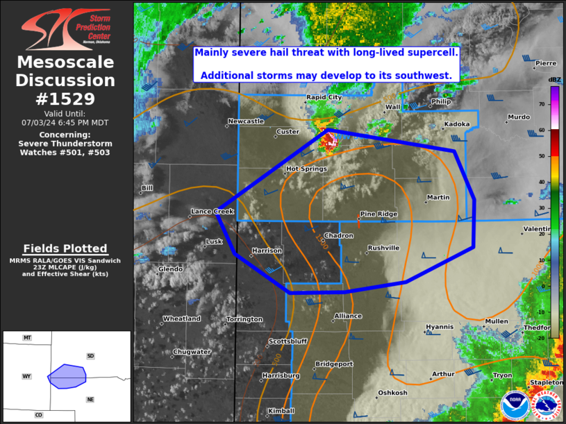
FOR ADDITIONAL INFORMATION SEE MESOSCALE DISCUSSION 1529
..MOORE..07/03/24
ATTN...WFO...UNR...
&&
STATUS REPORT FOR WS 503
SEVERE WEATHER THREAT CONTINUES FOR THE FOLLOWING AREAS
SDC007-047-071-102-103-040040-
SD
. SOUTH DAKOTA COUNTIES INCLUDED ARE
BENNETT FALL RIVER JACKSON
OGLALA LAKOTA PENNINGTON
$$
THE WATCH STATUS MESSAGE IS FOR GUIDANCE PURPOSES ONLY. PLEASE
REFER TO WATCH COUNTY NOTIFICATION STATEMENTS FOR OFFICIAL
INFORMATION ON COUNTIES...INDEPENDENT CITIES AND MARINE ZONES
CLEARED FROM SEVERE THUNDERSTORM AND TORNADO WATCHES.
$$
STATUS REPORT #1 ON WW 503
VALID 032230Z - 032340Z
THE SEVERE WEATHER THREAT CONTINUES ACROSS THE ENTIRE WATCH AREA.
..MOORE..07/03/24
ATTN...WFO...UNR...
&&
STATUS REPORT FOR WS 503
SEVERE WEATHER THREAT CONTINUES FOR THE FOLLOWING AREAS
SDC007-033-047-071-102-103-032340-
SD
. SOUTH DAKOTA COUNTIES INCLUDED ARE
BENNETT CUSTER FALL RIVER
JACKSON OGLALA LAKOTA PENNINGTON
$$
THE WATCH STATUS MESSAGE IS FOR GUIDANCE PURPOSES ONLY. PLEASE
REFER TO WATCH COUNTY NOTIFICATION STATEMENTS FOR OFFICIAL
INFORMATION ON COUNTIES...INDEPENDENT CITIES AND MARINE ZONES
CLEARED FROM SEVERE THUNDERSTORM AND TORNADO WATCHES.
$$
Note:
Click for Complete Product Text.
Tornadoes
Probability of 2 or more tornadoes
|
Low (20%)
|
Probability of 1 or more strong (EF2-EF5) tornadoes
|
Low (5%)
|
Wind
Probability of 10 or more severe wind events
|
Mod (50%)
|
Probability of 1 or more wind events > 65 knots
|
Low (20%)
|
Hail
Probability of 10 or more severe hail events
|
Mod (50%)
|
Probability of 1 or more hailstones > 2 inches
|
Mod (40%)
|
Combined Severe Hail/Wind
Probability of 6 or more combined severe hail/wind events
|
High (80%)
|
For each watch, probabilities for particular events inside the watch
(listed above in each table) are determined by the issuing forecaster.
The "Low" category contains probability values ranging from less than 2%
to 20% (EF2-EF5 tornadoes), less than 5% to 20% (all other probabilities),
"Moderate" from 30% to 60%, and "High" from 70% to greater than 95%.
High values are bolded and lighter in color to provide awareness of
an increased threat for a particular event.


 @NWSSPC