|
| Mesoscale Discussion 1609 |
|
< Previous MD Next MD >
|
|
Mesoscale Discussion 1609
NWS Storm Prediction Center Norman OK
0129 AM CDT Sun Jul 14 2024
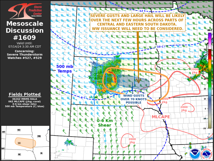
Areas affected...Central and Eastern South Dakota...Southwest
Minnesota
Concerning...Severe Thunderstorm Watch 527...529...
Valid 140629Z - 140830Z
The severe weather threat for Severe Thunderstorm Watch 527, 529
continues.
SUMMARY...A wind-damage and large-hail threat will likely continue
across parts of central and eastern South Dakota over the next few
hours, and could affect southwest Minnesota later tonight. Gusts
over 80 mph will be possible ahead of the ongoing bow. Weather watch
issuance will need to be considered for parts of eastern South
Dakota.
DISCUSSION...The latest mosaic radar imagery shows a well-developed
bow echo just to the west and northwest of Pierre, South Dakota. The
bow is moving east-southeastward along a corridor of moderate
instability, where the RAP is analyzing MLCAPE in the 1200 to 2000
J/kg range. The line appears to be supported by a 45 to 55 knot
mid-level speed max over northwestern South Dakota. As the line
continues to move east-southeastward at around 50 knots, severe
gusts will be likely along the leading edge of the bow. Wind gusts
above 80 mph will be possible near the apex of the bow. As the line
moves further east, it will encounter stronger instability across
southeastern South Dakota. This could help to maintain intensity
with the line, making weather watch issuance likely across parts of
eastern South Dakota and southwest Minnesota.
..Broyles.. 07/14/2024
...Please see www.spc.noaa.gov for graphic product...
ATTN...WFO...MPX...FSD...ABR...UNR...
LAT...LON 45020128 44590141 44290135 43980089 43709952 43399773
43299715 43389659 43509624 43859584 44559577 44899626
45109769 45269957 45330086 45020128
|
|
Top/All Mesoscale Discussions/Forecast Products/Home
|
|


 @NWSSPC