Note:
The expiration time in the watch graphic is amended if the watch is
replaced, cancelled or extended.
Note:
Note:
The expiration time in the watch graphic is amended if the watch is
replaced, cancelled or extended.
Note: Click for
Watch Status Reports.
SEL9
URGENT - IMMEDIATE BROADCAST REQUESTED
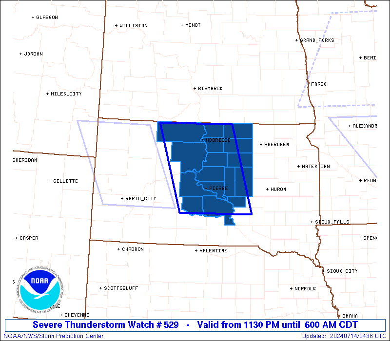
Severe Thunderstorm Watch Number 529
NWS Storm Prediction Center Norman OK
1130 PM CDT Sat Jul 13 2024
The NWS Storm Prediction Center has issued a
* Severe Thunderstorm Watch for portions of
Central South Dakota
* Effective this Saturday night and Sunday morning from 1130 PM
until 600 AM CDT.
* Primary threats include...
Scattered damaging winds likely with isolated significant gusts
to 85 mph possible
Isolated large hail events to 1.5 inches in diameter possible
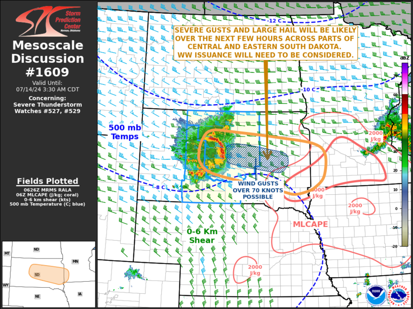
SUMMARY...A small but intense bowing cluster will move quickly
southeastward from northwest into central South Dakota through the
overnight hours. Scattered severe/damaging winds appear likely, with
some significant gusts up to around 85 mph possible. Isolated severe
hail may occur as well.
The severe thunderstorm watch area is approximately along and 60
statute miles east and west of a line from 30 miles north northwest
of Mobridge SD to 45 miles south southeast of Pierre SD. For a
complete depiction of the watch see the associated watch outline
update (WOUS64 KWNS WOU9).
PRECAUTIONARY/PREPAREDNESS ACTIONS...
REMEMBER...A Severe Thunderstorm Watch means conditions are
favorable for severe thunderstorms in and close to the watch area.
Persons in these areas should be on the lookout for threatening
weather conditions and listen for later statements and possible
warnings. Severe thunderstorms can and occasionally do produce
tornadoes.
&&
OTHER WATCH INFORMATION...CONTINUE...WW 524...WW 526...WW
527...WW 528...
AVIATION...A few severe thunderstorms with hail surface and aloft to
1.5 inches. Extreme turbulence and surface wind gusts to 75 knots. A
few cumulonimbi with maximum tops to 500. Mean storm motion vector
30040.
...Gleason

   SEL9

   URGENT - IMMEDIATE BROADCAST REQUESTED
   Severe Thunderstorm Watch Number 529
   NWS Storm Prediction Center Norman OK
   1130 PM CDT Sat Jul 13 2024

   The NWS Storm Prediction Center has issued a

   * Severe Thunderstorm Watch for portions of
     Central South Dakota

   * Effective this Saturday night and Sunday morning from 1130 PM
     until 600 AM CDT.

   * Primary threats include...
     Scattered damaging winds likely with isolated significant gusts
       to 85 mph possible
     Isolated large hail events to 1.5 inches in diameter possible

   SUMMARY...A small but intense bowing cluster will move quickly
   southeastward from northwest into central South Dakota through the
   overnight hours. Scattered severe/damaging winds appear likely, with
   some significant gusts up to around 85 mph possible. Isolated severe
   hail may occur as well.

   The severe thunderstorm watch area is approximately along and 60
   statute miles east and west of a line from 30 miles north northwest
   of Mobridge SD to 45 miles south southeast of Pierre SD. For a
   complete depiction of the watch see the associated watch outline
   update (WOUS64 KWNS WOU9).

   PRECAUTIONARY/PREPAREDNESS ACTIONS...

   REMEMBER...A Severe Thunderstorm Watch means conditions are
   favorable for severe thunderstorms in and close to the watch area.
   Persons in these areas should be on the lookout for threatening
   weather conditions and listen for later statements and possible
   warnings. Severe thunderstorms can and occasionally do produce
   tornadoes.

   &&

   OTHER WATCH INFORMATION...CONTINUE...WW 524...WW 526...WW
   527...WW 528...

   AVIATION...A few severe thunderstorms with hail surface and aloft to
   1.5 inches. Extreme turbulence and surface wind gusts to 75 knots. A
   few cumulonimbi with maximum tops to 500. Mean storm motion vector
   30040.

   ...Gleason
 Note:
The Aviation Watch (SAW) product is an approximation to the watch area.
The actual watch is depicted by the shaded areas.
Note:
The Aviation Watch (SAW) product is an approximation to the watch area.
The actual watch is depicted by the shaded areas.
   SAW9
   WW 529 SEVERE TSTM SD 140430Z - 141100Z
   AXIS..60 STATUTE MILES EAST AND WEST OF LINE..
   30NNW MBG/MOBRIDGE SD/ - 45SSE PIR/PIERRE SD/
   ..AVIATION COORDS.. 50NM E/W /50S BIS - 39SSE PIR/
   HAIL SURFACE AND ALOFT..1.5 INCHES. WIND GUSTS..75 KNOTS.
   MAX TOPS TO 500. MEAN STORM MOTION VECTOR 30040.

   LAT...LON 45929942 43779873 43770114 45920192

   THIS IS AN APPROXIMATION TO THE WATCH AREA.  FOR A
   COMPLETE DEPICTION OF THE WATCH SEE WOUS64 KWNS
   FOR WOU9.
Watch 529 Status Report Messages:
STATUS REPORT #2 ON WW 529

VALID 140730Z - 140840Z

SEVERE WEATHER THREAT CONTINUES RIGHT OF A LINE FROM 15 ENE PHP
TO 20 SE PIR TO 25 NE PIR TO 15 SSE MBG TO 40 N MBG.

..BROYLES..07/14/24

ATTN...WFO...ABR...

&&

STATUS REPORT FOR WS 529

SEVERE WEATHER THREAT CONTINUES FOR THE FOLLOWING AREAS

SDC017-021-045-049-059-069-075-085-089-107-129-140840-

SD
.    SOUTH DAKOTA COUNTIES INCLUDED ARE

BUFFALO 	     CAMPBELL		 EDMUNDS
FAULK		     HAND		 HYDE
JONES		     LYMAN		 MCPHERSON
POTTER		     WALWORTH
$$


THE WATCH STATUS MESSAGE IS FOR GUIDANCE PURPOSES ONLY.  PLEASE
REFER TO WATCH COUNTY NOTIFICATION STATEMENTS FOR OFFICIAL
INFORMATION ON COUNTIES...INDEPENDENT CITIES AND MARINE ZONES
CLEARED FROM SEVERE THUNDERSTORM AND TORNADO WATCHES.
$$

STATUS REPORT #1 ON WW 529

VALID 140700Z - 140840Z

SEVERE WEATHER THREAT CONTINUES RIGHT OF A LINE FROM 25 N PHP TO
30 SW PIR TO 10 SSE PIR TO 30 N PIR TO 25 SSW MBG TO 40 NNW MBG.

..BROYLES..07/14/24

ATTN...WFO...ABR...

&&

STATUS REPORT FOR WS 529

SEVERE WEATHER THREAT CONTINUES FOR THE FOLLOWING AREAS

SDC017-021-045-049-059-065-069-075-085-089-107-119-129-140840-

SD
.    SOUTH DAKOTA COUNTIES INCLUDED ARE

BUFFALO 	     CAMPBELL		 EDMUNDS
FAULK		     HAND		 HUGHES
HYDE		     JONES		 LYMAN
MCPHERSON	     POTTER		 SULLY
WALWORTH
$$


THE WATCH STATUS MESSAGE IS FOR GUIDANCE PURPOSES ONLY.  PLEASE
REFER TO WATCH COUNTY NOTIFICATION STATEMENTS FOR OFFICIAL
INFORMATION ON COUNTIES...INDEPENDENT CITIES AND MARINE ZONES
CLEARED FROM SEVERE THUNDERSTORM AND TORNADO WATCHES.
$$
Note:
Click for Complete Product Text.
Tornadoes
Probability of 2 or more tornadoes
|
Low (<5%)
|
Probability of 1 or more strong (EF2-EF5) tornadoes
|
Low (<2%)
|
Wind
Probability of 10 or more severe wind events
|
High (70%)
|
Probability of 1 or more wind events > 65 knots
|
Mod (50%)
|
Hail
Probability of 10 or more severe hail events
|
Mod (30%)
|
Probability of 1 or more hailstones > 2 inches
|
Low (20%)
|
Combined Severe Hail/Wind
Probability of 6 or more combined severe hail/wind events
|
High (90%)
|
For each watch, probabilities for particular events inside the watch
(listed above in each table) are determined by the issuing forecaster.
The "Low" category contains probability values ranging from less than 2%
to 20% (EF2-EF5 tornadoes), less than 5% to 20% (all other probabilities),
"Moderate" from 30% to 60%, and "High" from 70% to greater than 95%.
High values are bolded and lighter in color to provide awareness of
an increased threat for a particular event.


 @NWSSPC