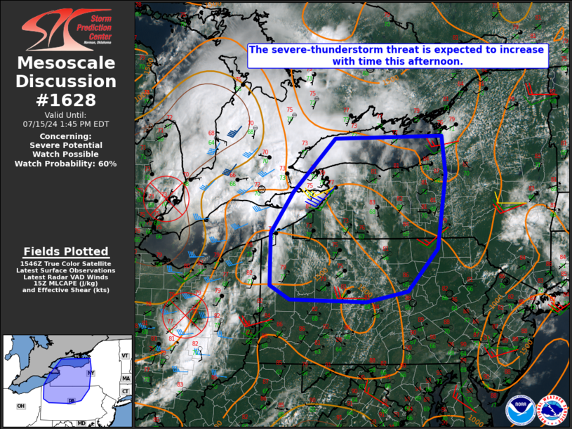
   Mesoscale Discussion 1628
   NWS Storm Prediction Center Norman OK
   1052 AM CDT Mon Jul 15 2024

   Areas affected...Parts of western/central NY/PA

   Concerning...Severe potential...Watch possible

   Valid 151552Z - 151745Z

   Probability of Watch Issuance...60 percent

   SUMMARY...The severe-thunderstorm threat is expected to increase
   with time this afternoon, with damaging wind, isolated hail, and a
   tornado or two all possible. Watch issuance is possible by early/mid
   afternoon.

   DISCUSSION...A well-defined MCV is moving across southeast lower MI
   late this morning, with another MCV noted over central OH.
   Downstream of these MCVs, filtered heating of a relatively moist
   environment will result in MLCAPE increasing into the 1500-2000 J/kg
   range. Meanwhile, relatively enhanced midlevel flow to the south of
   the northernmost MCV will support effective shear of 30-40 kt into
   the afternoon, resulting in a conditionally favorable environment
   for organized convection across parts of western/central NY/PA.

   Ongoing convection over southern ON and northeast Lake Erie may
   eventually spread into parts of western NY and over Lake Ontario
   through late morning, which could pose a threat of isolated damaging
   wind and perhaps some hail. Stronger redevelopment is expected by
   early/mid afternoon from eastern Lake Erie into parts of western
   NY/northwest PA, in closer proximity to the approaching MCV. Storm
   coverage with southward extent is more uncertain, but eventual
   development into a larger portion of western/central PA will also be
   possible.

   A tendency toward storm clustering and possible development of a
   compact MCS is currently expected, with a primary threat of damaging
   wind gusts as storms move eastward through the afternoon. A couple
   supercells will also be possible, especially early in the storm
   evolution, which could pose a threat for isolated hail and possibly
   a tornado or two. Watch issuance will become increasingly possible
   early this afternoon in order to address these threats.

   ..Dean/Hart.. 07/15/2024

   ...Please see www.spc.noaa.gov for graphic product...

   ATTN...WFO...BGM...BUF...CTP...PBZ...CLE...

   LAT...LON   43847610 43157601 41807624 41037696 40857797 40897982
               41148030 42088030 42837976 43817873 43847610
|


 @NWSSPC