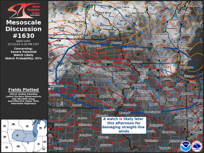
   Mesoscale Discussion 1630
   NWS Storm Prediction Center Norman OK
   0159 PM CDT Mon Jul 15 2024

   Areas affected...Central Iowa...Southern Wisconsin...and Northern
   Illinois

   Concerning...Severe potential...Watch likely

   Valid 151859Z - 152130Z

   Probability of Watch Issuance...95 percent

   SUMMARY...A severe thunderstorm watch is likely later this afternoon
   for portions of Iowa into Northern Illinois and Southern Wisconsin
   in anticipation of convective initiation, forecast to occur between
   19-21Z. Thunderstorms are expected to grow upscale quickly into a
   bowing line, which will be capable of 80+ MPH winds, though 1.00+
   inch hail and embedded tornadoes are also possible.

   DISCUSSION...A subtle shortwave trough evident in both water vapor
   channel satellite imagery and RAP analyses is progressing eastward
   across southwest Minnesota. This shortwave is expected to provide
   additional ascent for convective initiation between 19-21Z over what
   is already a moist and unstable airmass, with widespread areas of
   MLCAPE > 3500 J/kg. This convective initiation is expected to occur
   anywhere from southern Minnesota, along the existing band of
   cloudiness, to central Iowa, where MLCINH has already eroded.

   Forecast profiles in north-central Iowa around the time of
   convective initiation show some slight curvature of the hodograph,
   resulting in modest 0-3km SRH of around 120 m^2/s^2. This will
   support the potential for tornadoes with any storms that remain
   isolated/discrete, but the overall expectation is for rapid upscale
   growth into a bowing MCS. The primary concern this evening is for
   damaging straight-line winds in excess of 80 MPH associated with
   this MCS, in addition to 1.00+ inch hail.

   Further east into Illinois, forecast hodographs show more favorable
   curvature and streamwise vorticity along and south of the surface
   boundary. Given the environment and expected storm mode, embedded
   QLCS tornadoes appear possible.

   ..Halbert/Squitieri/Hart.. 07/15/2024

   ...Please see www.spc.noaa.gov for graphic product...

   ATTN...WFO...IWX...LOT...ILX...MKX...DVN...ARX...DMX...

   LAT...LON   40649275 40969405 41239482 42219489 43059426 43389353
               43309230 43259137 43219053 43158964 43168882 43108812
               43098791 42958771 42828744 42418706 42048683 41418670
               40848684 40588733 40448868 40398983 40409055 40649275
|


 @NWSSPC