|
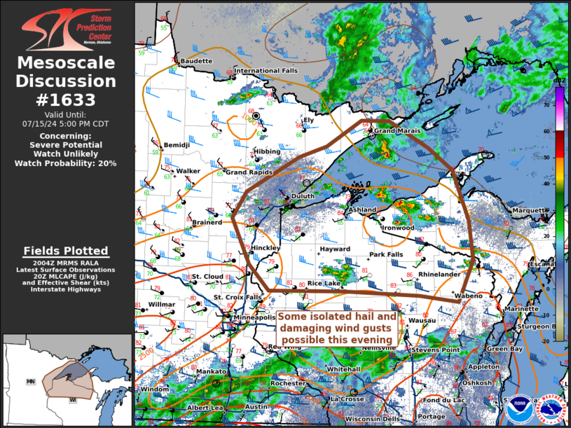
| Mesoscale Discussion 1633 |
|
< Previous MD Next MD >
|

|
   Mesoscale Discussion 1633
   NWS Storm Prediction Center Norman OK
   0306 PM CDT Mon Jul 15 2024

   Areas affected...Eastern Minnesota...Northern Wisconsin...and the
   Michigan Upper Peninsula

   Concerning...Severe potential...Watch unlikely

   Valid 152006Z - 152200Z

   Probability of Watch Issuance...20 percent

   SUMMARY...As a cold front moves out of Minnesota, into Northwest
   Wisconsin, and eventually into the Upper Peninsula, thunderstorm
   coverage and intensity is expected to increase this afternoon and
   evening. While these storms will be capable of producing some
   damaging wind gusts and perhaps some 1.00 inch hail, watch issuance
   is not expected at this time given the isolated nature of severe
   occurrence.

   DISCUSSION...Thunderstorms have begun developing within a modestly
   unstable airmass across the Upper Peninsula/Northern Wisconsin into
   Eastern Minnesota. Thunderstorm activity will increase as a cold
   front moves southeastward out of Minnesota into Wisconsin, and deep
   layer shear magnitudes of 35-40 kts will support at least some
   isolated severe convection. Given relatively straight-line forecast
   hodographs and thin buoyancy profiles, isolated damaging wind gusts
   and hail are the primary hazards expected with any mature multicell
   clusters that develop.

   ..Halbert/Squitieri/Hart.. 07/15/2024

   ...Please see www.spc.noaa.gov for graphic product...

   ATTN...WFO...MQT...GRB...DLH...MPX...

   LAT...LON   46919302 47429190 47589132 47979056 47968996 47568913
               47228862 46488829 45898821 45298854 45398935 45469092
               45459252 45839293 46529331 46919302
|
|
Top/All Mesoscale Discussions/Forecast Products/Home
|
|


