|
| Mesoscale Discussion 1639 |
|
< Previous MD Next MD >
|
|
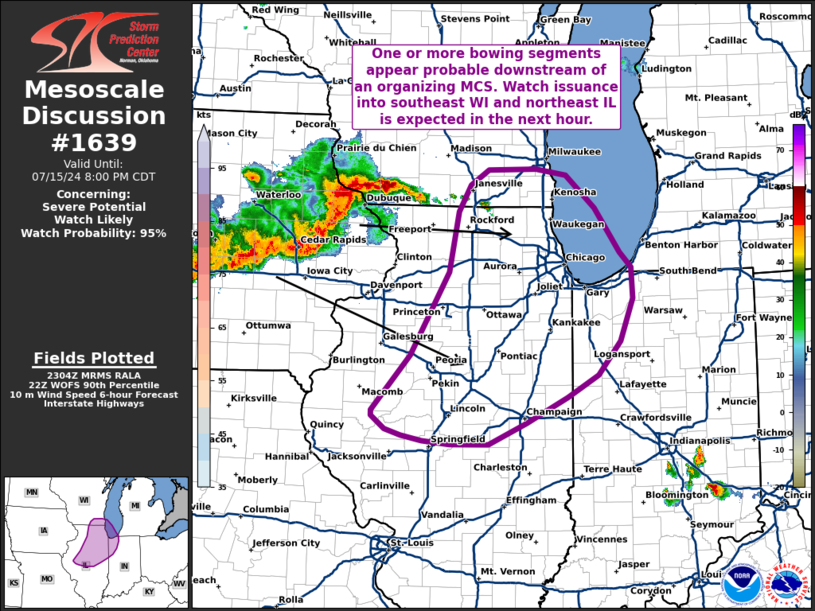
   Mesoscale Discussion 1639
   NWS Storm Prediction Center Norman OK
   0606 PM CDT Mon Jul 15 2024

   Areas affected...Far southeast Wisconsin into central and northeast
   Illinois

   Concerning...Severe potential...Watch likely

   Valid 152306Z - 160100Z

   Probability of Watch Issuance...95 percent

   SUMMARY...An organizing MCS across eastern Iowa is expected to move
   into central and northeastern IL, and perhaps far southeast WI,
   later this evening. Recent convective trends and high-res ensemble
   guidance suggest one or more bowing segments will be possible; watch
   issuance is expected in the near term.

   DISCUSSION...MCS organization continues across central to eastern IA
   with multiple measured and estimated severe wind gusts noted over
   the past hour. Temperatures falling into the low 70s and upper 60s
   in the wake of the line of storms indicates that a strong/deep cold
   pool is becoming established. Recent high-res WoFS guidance has
   assimilated these recent convective trends well and depicts at least
   one, possibly two, more focused bowing segments emerging later this
   evening across central to northern IL with winds possibly up to 70
   knots. Additionally, favorable low-level wind shear (upwards of 30
   knots) within the 0-3 km layer should support the potential for
   embedded circulations with the line, especially north of any bowing
   segments. Downstream watch issuance is expected within the next hour
   to address this concern.

   ..Moore/Thompson.. 07/15/2024

   ...Please see www.spc.noaa.gov for graphic product...

   ATTN...WFO...IWX...IND...LOT...ILX...MKX...DVN...

   LAT...LON   40199050 40828992 41758936 42448921 42748904 42908876
               42918805 42848760 42488718 41988681 41818664 41458661
               40978681 40608713 40348759 40068821 39818877 39818902
               39818934 39868975 39919006 39999029 40149049 40199050
|
|
Top/All Mesoscale Discussions/Forecast Products/Home
|
|


 @NWSSPC