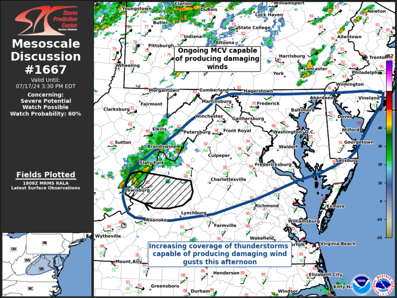
   Mesoscale Discussion 1667
   NWS Storm Prediction Center Norman OK
   0111 PM CDT Wed Jul 17 2024

   Areas affected...Virginia into Maryland

   Concerning...Severe potential...Watch possible

   Valid 171811Z - 171930Z

   CORRECTED FOR GRAPHIC LABEL PLACEMENT

   Probability of Watch Issuance...60 percent

   SUMMARY...A severe thunderstorm watch could be needed this afternoon
   as thunderstorm coverage increases, with the primary threat being
   for some damaging wind gusts.

   DISCUSSION...A severe thunderstorm watch may be needed this
   afternoon as thunderstorm coverage increases. Surface temperatures
   in northern Virginia and into Maryland have warmed into the
   mid-to-upper 90s F, with dew points in the mid-to-upper 60s F. While
   the boundary layer moisture is only supportive of modest MLCAPE
   (currently 500 J/kg, forecast to be 1000-1500 J/kg), and deep-layer
   shear is only around 25 kts, forecast profiles and SPC Mesoanalysis
   show very steep 0-3 km lapse rates across the Mid Atlantic. These
   steep lapse rates will allow for efficient mixing of thunderstorm
   winds to the surface, and perhaps even some microburst activity,
   which could result in some localized reports of damaging winds. This
   is supported by recent WoFS guidance, which shows increasing
   confidence in 40-50 MPH wind gusts.

   Additionally, an ongoing MCV progressing eastward out of West
   Virginia may result in a localized threat for damaging wind gusts as
   it moves east-southeast through Virginia. The environment only
   supports meager buoyancy in the short term, and radar trends don't
   indicate much intensification at this time, but steep low-level
   lapse rates support at least some damaging wind threat.

   ..Halbert/Squitieri/Hart.. 07/17/2024

   ...Please see www.spc.noaa.gov for graphic product...

   ATTN...WFO...PHI...AKQ...LWX...RNK...RLX...

   LAT...LON   37378017 37458033 37588040 37738045 37868045 38018039
               38208028 38368012 38907926 39147895 39377858 39557831
               39647797 39647746 39647673 39657599 39647548 39667478
               39617441 39427445 39197465 38887488 38597507 38447525
               38327558 38197593 38087640 37737737 37467837 37337936
               37337980 37378017
|


 @NWSSPC