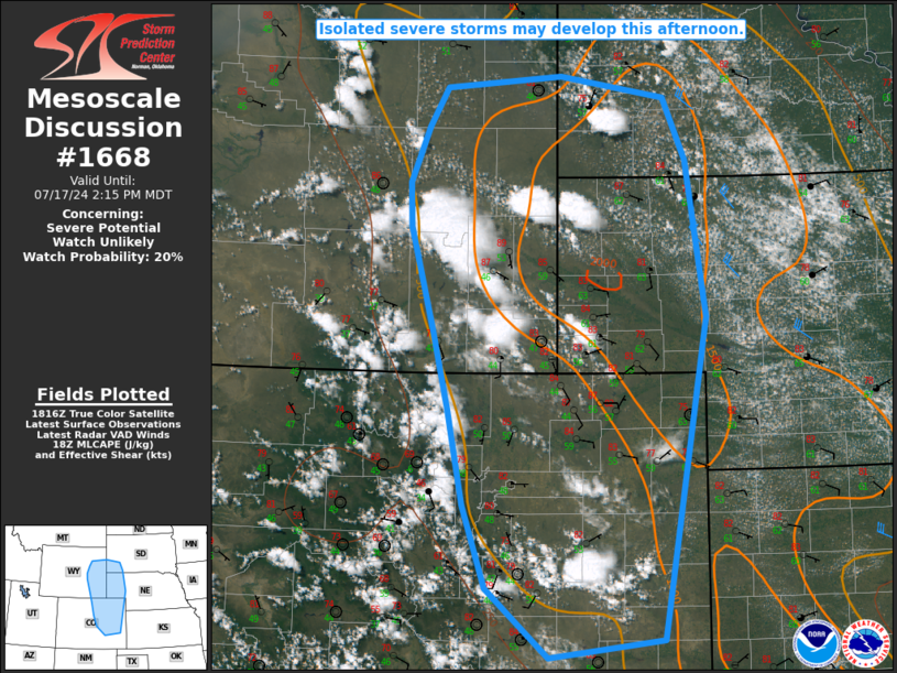
   Mesoscale Discussion 1668
   NWS Storm Prediction Center Norman OK
   0120 PM CDT Wed Jul 17 2024

   Areas affected...Eastern CO/WY...southwest SD...NE Panhandle

   Concerning...Severe potential...Watch unlikely

   Valid 171820Z - 172015Z

   Probability of Watch Issuance...20 percent

   SUMMARY...Isolated severe storms are possible this afternoon.

   DISCUSSION...Thunderstorms have developed early this afternoon from
   southeast WY into southwest SD, the NE Panhandle, and eastern CO,
   with severe hail recently reported over Niobrara County, WY. Despite
   the relatively early time of day, diminishing MLCINH could support
   continued storm development through mid afternoon. Relatively rich
   low-level moisture has spread into parts of southeast WY and the NE
   Panhandle, which is supporting MLCAPE of 1500-2000 J/kg, with
   somewhat lesser buoyancy noted into parts of the CO Front Range.
   Modest northwesterly flow aloft will support some potential for
   storm organization, and a few stronger multicells and perhaps a
   supercell or two are possible, with a threat of isolated hail and
   localized severe gusts.

   With the threat expected to remain rather isolated through mid
   afternoon, short-term watch issuance is considered unlikely. Watch
   issuance is still possible at some point later this afternoon, if
   observational trends support an increasing coverage of discrete
   cells, and/or some indication of more organized clustering and
   incipient upscale growth.

   ..Dean/Hart.. 07/17/2024

   ...Please see www.spc.noaa.gov for graphic product...

   ATTN...WFO...LBF...UNR...GLD...PUB...BOU...CYS...

   LAT...LON   43500582 43910556 44020400 43800258 43170229 41570203
               38260263 38080417 38790500 39650531 40620552 41430573
               42480605 42940606 43500582
|


 @NWSSPC