|
| Mesoscale Discussion 1671 |
|
< Previous MD Next MD >
|
|
Mesoscale Discussion 1671
NWS Storm Prediction Center Norman OK
0326 PM CDT Wed Jul 17 2024
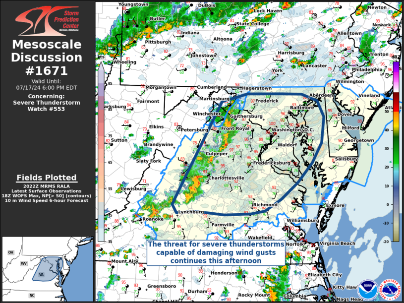
Areas affected...Northern Virginia and Maryland
Concerning...Severe Thunderstorm Watch 553...
Valid 172026Z - 172200Z
The severe weather threat for Severe Thunderstorm Watch 553
continues.
SUMMARY...The severe thunderstorm threat for WW 553 continues, with
the primary threat being for thunderstorms capable of damaging wind
gusts.
DISCUSSION...Thunderstorm coverage has increased on the western
periphery of the watch area, with current radar reflectivity showing
some initial organization of convection into bowing segments.
These thunderstorms are in an environment characterized by weak
deep-layer vertical shear and only modest buoyancy, but steep
low-level lapse rates and relatively dry sub-cloud layer forecast
profiles support the continued downward transport of momentum from
thunderstorm downdrafts. The greatest threat for wind damage will be
with any organized bowing segments, as well as where favorable
thunderstorm outflow mergers occur. Additionally, short-term WoFS
guidance suggests elevated probabilities of 50+ MPH wind gusts over
the next several hours.
This convective activity is expected to continue to progress
eastward into Maryland this afternoon and into this evening, before
eventually dying off as the nocturnal boundary-layer stabilizes.
..Halbert/Squitieri.. 07/17/2024
...Please see www.spc.noaa.gov for graphic product...
ATTN...WFO...PHI...AKQ...LWX...RNK...
LAT...LON 37607926 38067899 38797855 39467815 39607756 39607681
39597631 39477595 39177580 38727587 38357609 38017641
37717679 37507717 37457748 37437807 37487873 37467915
37607926
|
|
Top/All Mesoscale Discussions/Forecast Products/Home
|
|


 @NWSSPC