|
| Mesoscale Discussion 1672 |
|
< Previous MD Next MD >
|

|
   Mesoscale Discussion 1672
   NWS Storm Prediction Center Norman OK
   0349 PM CDT Wed Jul 17 2024

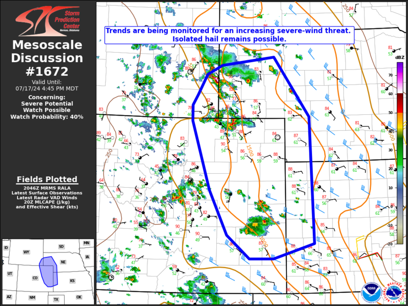
   Areas affected...Extreme southeast WY into the NE
   Panhandle...eastern CO and extreme western KS

   Concerning...Severe potential...Watch possible

   Valid 172049Z - 172245Z

   Probability of Watch Issuance...40 percent

   SUMMARY...Trends are being monitored for an increasing severe-wind
   threat. Isolated hail remains possible.

   DISCUSSION...At 2045 UTC, convective outflow was moving southward
   near the common border of WY/NE/CO, southeast of Cheyenne, and some
   recent tendency for increasing convection near the outflow has been
   noted. In the short term, moderate buoyancy (MLCAPE of 1000-1500
   J/kg) and marginally sufficient deep-layer shear could continue to
   support isolated marginal supercells, with an attendant threat of
   large hail and localized severe gusts.

   There is some potential for this outflow to grow with time and
   potentially consolidate with outflow from storms closer to the CO
   Front Range. Should this occur, a somewhat greater severe-wind
   threat could evolve late this afternoon into early evening, and
   watch issuance would be possible in order to address this threat.
   Otherwise, occasionally organized semi-discrete cells could continue
   to pose a threat of isolated hail and severe gusts across parts of
   eastern CO and adjacent portions of southeast WY and western NE/KS
   through late afternoon.

   ..Dean/Hart.. 07/17/2024

   ...Please see www.spc.noaa.gov for graphic product...

   ATTN...WFO...LBF...DDC...GLD...PUB...BOU...CYS...

   LAT...LON   38330376 39350429 40940482 41300481 41520466 41990439
               42200393 42400236 41020132 38130121 37790241 37790311
               38330376
|
|
Top/All Mesoscale Discussions/Forecast Products/Home
|
|


