|
| Mesoscale Discussion 2209 |
|
< Previous MD Next MD >
|
|
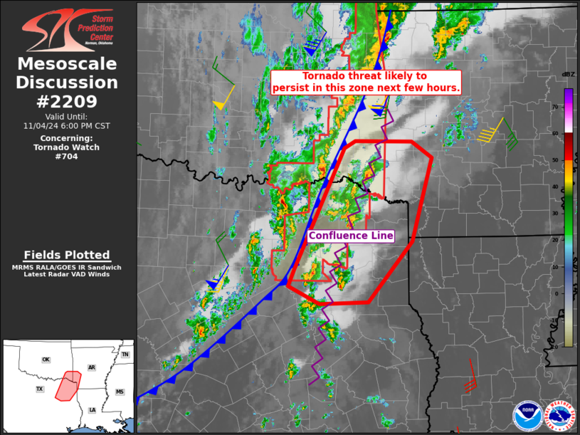
   Mesoscale Discussion 2209
   NWS Storm Prediction Center Norman OK
   0505 PM CST Mon Nov 04 2024

   Areas affected...northeast Texas...far southeast
   Oklahoma...southwest Arkansas

   Concerning...Tornado Watch 704...

   Valid 042305Z - 050000Z

   The severe weather threat for Tornado Watch 704 continues.

   SUMMARY...A tornado threat is likely to persist over northeast
   Texas, far southeast Oklahoma, and southwest Arkansas this evening.

   DISCUSSION...Convection within a confluence line beneath the 50 kt
   low-level jet has gradually strengthened, with supercells now
   evident. This zone remains in a favorable shear and instability
   space, with 0-1 SRH over 250 m2/s2 and high surface theta-e values
   ahead of the cold front. Surface observations also indicate winds
   gusting over 25 kt, indicative of the coupled boundary layer and
   expected full incorporation of available low-level shear. As such, a
   new watch will be needed for parts of the region, with threat
   persisting until the cold front pushes through.

   ..Jewell.. 11/04/2024

   ...Please see www.spc.noaa.gov for graphic product...

   ATTN...WFO...LZK...SHV...TSA...FWD...

   LAT...LON   32269621 32539610 34389521 34509500 34489397 34239360
               33569379 32959397 32029476 32009564 32269621
|
|
Top/All Mesoscale Discussions/Forecast Products/Home
|
|


 @NWSSPC