|
| Mesoscale Discussion 2208 |
|
< Previous MD Next MD >
|
|
Mesoscale Discussion 2208
NWS Storm Prediction Center Norman OK
0338 PM CST Mon Nov 04 2024
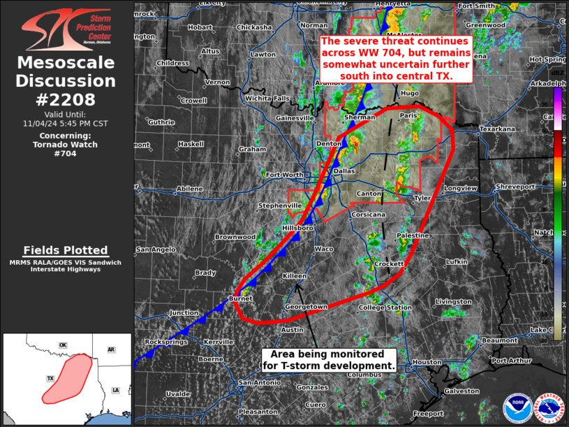
Areas affected...Central to northeast Texas
Concerning...Tornado Watch 704...
Valid 042138Z - 042345Z
The severe weather threat for Tornado Watch 704 continues.
SUMMARY...The severe threat continues across northern TX/WW 704, but
becomes less clear further south into central TX where convection
along a cold front has been slow to develop.
DISCUSSION...Over the past 1-2 hours, supercells across the DFW area
have struggled to become well organized despite a favorable
thermodynamic and kinematic environment. Some uptick in intensity
has been noted over the past 20-30 minutes as these cells begin to
interact with the approaching cold front/outflow boundary. A large
hail threat will likely persist for the next hour before these
storms fully transition into a somewhat more consolidated and
balanced line. After this point, the potential for damaging/severe
winds should increase downstream into northeast TX with an attendant
threat for embedded circulations given the favorable low-level wind
profile (0-1 km SRH remains at around 150 m2/s2).
Ahead of this line, shallower convection developing along a weak
confluence axis continues to percolate across northeastern TX. This
activity resides on the western periphery of a somewhat more buoyant
air mass (SBCAPE upwards of 2500 J/kg), but weak forcing for ascent
casts some uncertainty onto how intense this convection will become.
These storms reside well within the best low-level kinematic fields
based on recent upper-air analyses. If a robust supercell can be
established, a more prominent hail/tornado threat may emerge.
Further south along the front into central TX, convective
development has been meager with only a few attempts at deeper
convection noted in satellite imagery. The downstream environment
ahead of the front remains favorable for robust convection, which
would likely develop quickly into an organized line, and latest CAM
solutions continue to suggest that development across central TX is
likely in the coming hours. Trends are being monitored, and watch
issuance may be needed once robust initiation along the front
becomes apparent.
..Moore.. 11/04/2024
...Please see www.spc.noaa.gov for graphic product...
ATTN...WFO...SHV...TSA...HGX...FWD...OUN...EWX...SJT...
LAT...LON 31239554 31049583 30939610 30499759 30439812 30509841
30779858 30949852 31129839 31399805 31789763 32079736
32459714 33389667 33859576 33879514 33729478 33509453
33199451 31549533 31239554
|
|
Top/All Mesoscale Discussions/Forecast Products/Home
|
|


 @NWSSPC