|
| Mesoscale Discussion 2216 |
|
< Previous MD Next MD >
|
|
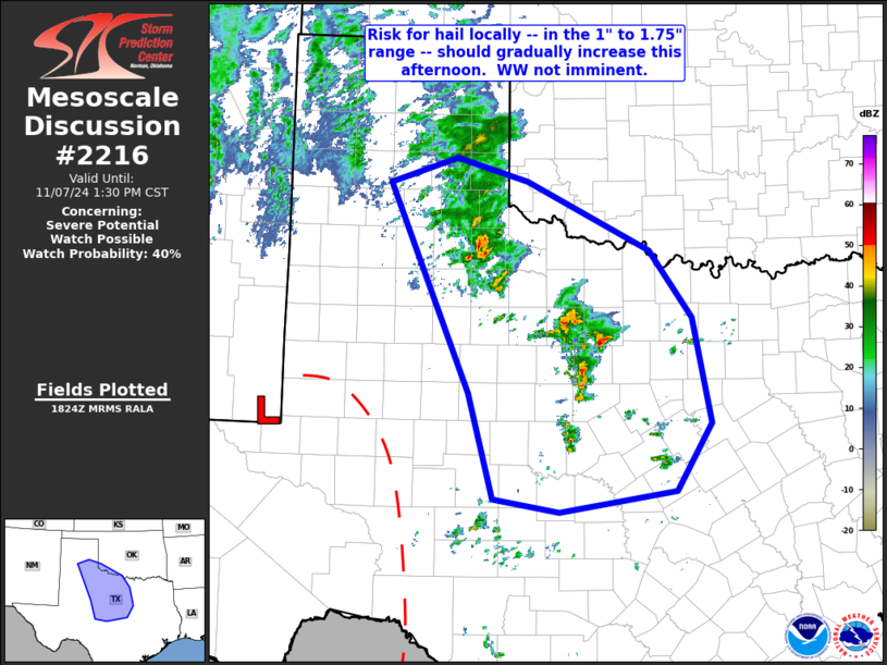
   Mesoscale Discussion 2216
   NWS Storm Prediction Center Norman OK
   1226 PM CST Thu Nov 07 2024

   Areas affected...portions of central and northwestern Texas and
   adjacent southwestern Oklahoma

   Concerning...Severe potential...Watch possible

   Valid 071826Z - 071930Z

   Probability of Watch Issuance...40 percent

   SUMMARY...Risk for hail locally -- in the 1" to 1.75" range -- is
   expected to very gradually increase over the next few hours.  WW
   issuance is not anticipated in the short term, though may be
   considered if storms increase more rapidly in coverage/intensity
   than currently anticipated.

   DISCUSSION...Latest water vapor loop and mid-level height field
   indicates a well-defined low centered over Arizona.  Downstream,
   across the southern High Plains, strong/diffluent flow is in place
   -- supporting a zone of favorable/enhanced low-level warm
   advection/southeasterly flow atop a relatively cool/stable boundary
   layer.

   Within this zone of favorable quasi-geostrophic ascent, a gradual
   ramp-up in storm coverage and intensity has been observed over the
   past hour or so, with a couple of strong cells now over the western
   North Texas/Big Country region.  With ample elevated CAPE indicated
   (averaging 750 to 1250 J/kg), and veering/increasing flow through
   the cloud-bearing layer, organized storms -- a few with mid-level
   rotation -- are suggested by this background environment.  While the
   overall risk does not warrant serious WW consideration at this time,
   we will continue to closely monitor what should be a gradual ramp-up
   in storm coverage over the next several hours.

   ..Goss/Hart.. 11/07/2024

   ...Please see www.spc.noaa.gov for graphic product...

   ATTN...WFO...FWD...OUN...SJT...LUB...AMA...MAF...

   LAT...LON   34820163 35110071 34849973 34049805 33269747 32059723
               31269770 31029929 31180019 32390054 34820163
|
|
Top/All Mesoscale Discussions/Forecast Products/Home
|
|


 @NWSSPC