|
| Mesoscale Discussion 2228 |
|
< Previous MD Next MD >
|
|
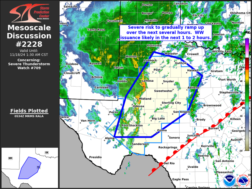
   Mesoscale Discussion 2228
   NWS Storm Prediction Center Norman OK
   1136 PM CST Sun Nov 17 2024

   Areas affected...portions of western Texas

   Concerning...Severe Thunderstorm Watch 709...

   Valid 180536Z - 180730Z

   The severe weather threat for Severe Thunderstorm Watch 709
   continues.

   SUMMARY...Strong storms continue in a frontal band crossing western
   Texas, where damaging winds and marginal hail are possible.

   DISCUSSION...Latest radar loop shows a broken band of locally
   vigorous convection occurring ahead of a cold front
   organizing/moving eastward across far West Texas at this time.  Very
   strong flow aloft -- including winds in excess of 50 kt just 1km AGL
   -- continues to support local storm organization, including bowing
   segments at least transiently organizing within the convective band.

   At this time, weak instability remains a limiting factor, in terms
   of more robust severe risk.  With that said, a surface warm front
   continues shifting rapidly northward/northwestward across central
   Texas, at the leading edge of a high theta-e (low 70s dewpoints)
   airmass.  As storms advance slowly eastward, and higher theta-e air
   continues advecting northwestward, an eventual uptick in risk is
   expected.

   ..Goss.. 11/18/2024

   ...Please see www.spc.noaa.gov for graphic product...

   ATTN...WFO...FWD...OUN...SJT...LUB...MAF...

   LAT...LON   30500320 32180266 34000133 33730002 33019896 31559970
               30510143 30500320
|
|
Top/All Mesoscale Discussions/Forecast Products/Home
|
|


 @NWSSPC