Note:
The expiration time in the watch graphic is amended if the watch is
replaced, cancelled or extended.
Note:
Note:
The expiration time in the watch graphic is amended if the watch is
replaced, cancelled or extended.
Note: Click for
Watch Status Reports.
SEL9
URGENT - IMMEDIATE BROADCAST REQUESTED
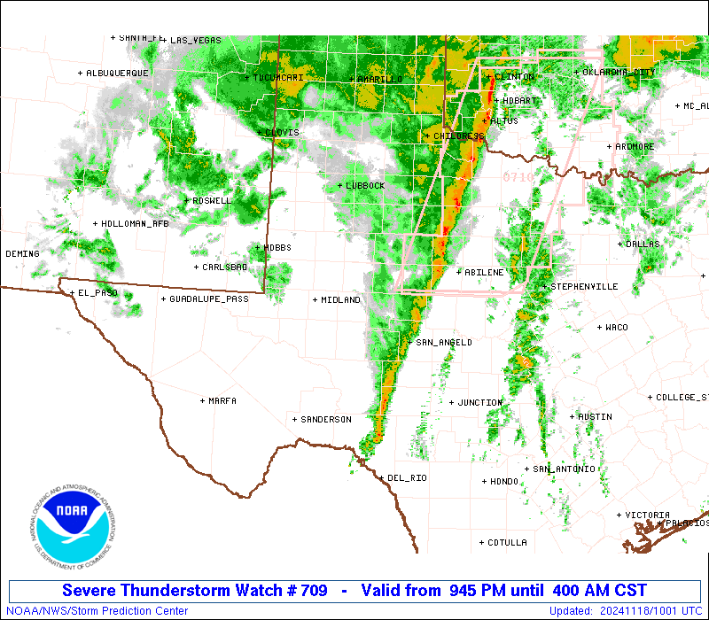
Severe Thunderstorm Watch Number 709
NWS Storm Prediction Center Norman OK
945 PM CST Sun Nov 17 2024
The NWS Storm Prediction Center has issued a
* Severe Thunderstorm Watch for portions of
West Texas
* Effective this Sunday night and Monday morning from 945 PM
until 400 AM CST.
* Primary threats include...
Scattered damaging winds likely with isolated significant gusts
to 75 mph possible
A tornado or two possible
SUMMARY...A line of thunderstorms will intensify tonight over west
Texas and accelerate northeastward across the watch area. Damaging
wind gusts are the primary concern, although there will be an
increasing risk of an embedded tornado or two with time.
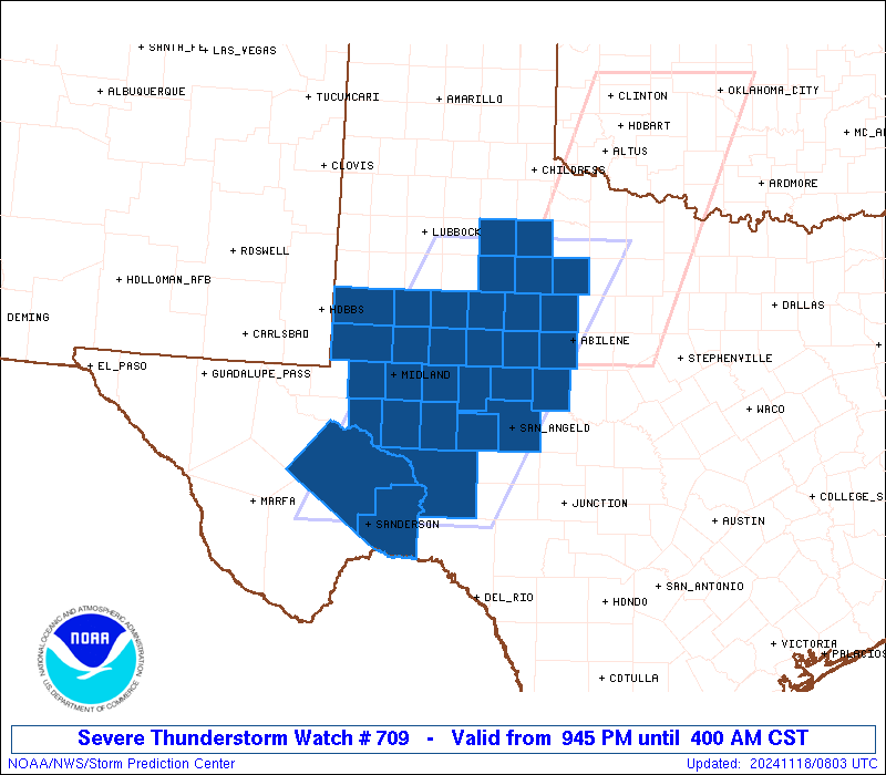
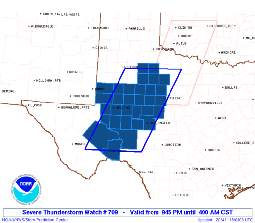
The severe thunderstorm watch area is approximately along and 80
statute miles east and west of a line from 70 miles southeast of
Fort Stockton TX to 90 miles north northwest of Abilene TX. For a
complete depiction of the watch see the associated watch outline
update (WOUS64 KWNS WOU9).
PRECAUTIONARY/PREPAREDNESS ACTIONS...
REMEMBER...A Severe Thunderstorm Watch means conditions are
favorable for severe thunderstorms in and close to the watch area.
Persons in these areas should be on the lookout for threatening
weather conditions and listen for later statements and possible
warnings. Severe thunderstorms can and occasionally do produce
tornadoes.
&&
AVIATION...A few severe thunderstorms with hail surface and aloft to
0.5 inches. Extreme turbulence and surface wind gusts to 65 knots. A
few cumulonimbi with maximum tops to 450. Mean storm motion vector
23035.
...Hart

   SEL9

   URGENT - IMMEDIATE BROADCAST REQUESTED
   Severe Thunderstorm Watch Number 709
   NWS Storm Prediction Center Norman OK
   945 PM CST Sun Nov 17 2024

   The NWS Storm Prediction Center has issued a

   * Severe Thunderstorm Watch for portions of
     West Texas

   * Effective this Sunday night and Monday morning from 945 PM
     until 400 AM CST.

   * Primary threats include...
     Scattered damaging winds likely with isolated significant gusts
       to 75 mph possible
     A tornado or two possible

   SUMMARY...A line of thunderstorms will intensify tonight over west
   Texas and accelerate northeastward across the watch area.  Damaging
   wind gusts are the primary concern, although there will be an
   increasing risk of an embedded tornado or two with time.

   The severe thunderstorm watch area is approximately along and 80
   statute miles east and west of a line from 70 miles southeast of
   Fort Stockton TX to 90 miles north northwest of Abilene TX. For a
   complete depiction of the watch see the associated watch outline
   update (WOUS64 KWNS WOU9).

   PRECAUTIONARY/PREPAREDNESS ACTIONS...

   REMEMBER...A Severe Thunderstorm Watch means conditions are
   favorable for severe thunderstorms in and close to the watch area.
   Persons in these areas should be on the lookout for threatening
   weather conditions and listen for later statements and possible
   warnings. Severe thunderstorms can and occasionally do produce
   tornadoes.

   &&

   AVIATION...A few severe thunderstorms with hail surface and aloft to
   0.5 inches. Extreme turbulence and surface wind gusts to 65 knots. A
   few cumulonimbi with maximum tops to 450. Mean storm motion vector
   23035.

   ...Hart
 Note:
The Aviation Watch (SAW) product is an approximation to the watch area.
The actual watch is depicted by the shaded areas.
Note:
The Aviation Watch (SAW) product is an approximation to the watch area.
The actual watch is depicted by the shaded areas.
   SAW9
   WW 709 SEVERE TSTM TX 180345Z - 181000Z
   AXIS..80 STATUTE MILES EAST AND WEST OF LINE..
   70SE FST/FORT STOCKTON TX/ - 90NNW ABI/ABILENE TX/
   ..AVIATION COORDS.. 70NM E/W /64SE FST - 45S CDS/
   HAIL SURFACE AND ALOFT..0.5 INCH. WIND GUSTS..65 KNOTS.
   MAX TOPS TO 450. MEAN STORM MOTION VECTOR 23035.

   LAT...LON 30190343 33610167 33619889 30190075

   THIS IS AN APPROXIMATION TO THE WATCH AREA.  FOR A
   COMPLETE DEPICTION OF THE WATCH SEE WOUS64 KWNS
   FOR WOU9.
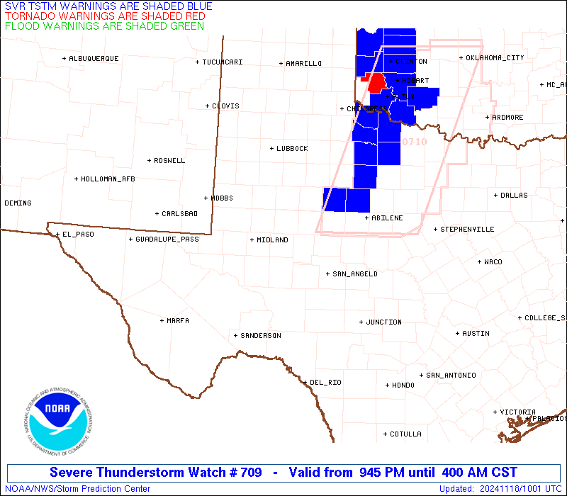
Watch 709 Status Report Messages:
STATUS REPORT #6 ON WW 709
VALID 180935Z - 181000Z
SEVERE WEATHER THREAT CONTINUES RIGHT OF A LINE FROM 55 ENE 6R6
TO 50 WSW ABI TO 55 S CDS.
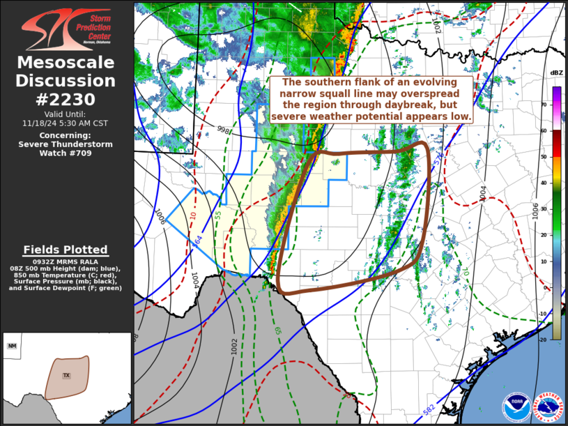
WW 709 MAY BE ALLOWED TO EXPIRE AT 18/10Z. REFER TO SPC MESOSCALE
DISCUSSION 2230 FOR MORE INFORMATION.
..KERR..11/18/24
ATTN...WFO...MAF...SJT...LUB...
&&
STATUS REPORT FOR WS 709
SEVERE WEATHER THREAT CONTINUES FOR THE FOLLOWING AREAS
TXC081-105-235-269-399-433-451-181000-
TX
. TEXAS COUNTIES INCLUDED ARE
COKE CROCKETT IRION
KING RUNNELS STONEWALL
TOM GREEN
$$
THE WATCH STATUS MESSAGE IS FOR GUIDANCE PURPOSES ONLY. PLEASE
REFER TO WATCH COUNTY NOTIFICATION STATEMENTS FOR OFFICIAL
INFORMATION ON COUNTIES...INDEPENDENT CITIES AND MARINE ZONES
CLEARED FROM SEVERE THUNDERSTORM AND TORNADO WATCHES.
$$
STATUS REPORT #5 ON WW 709
VALID 180900Z - 181040Z
SEVERE WEATHER THREAT CONTINUES RIGHT OF A LINE FROM 30 ENE 6R6
TO 40 W SJT TO 40 E BGS TO 55 S CDS.
..KERR..11/18/24
ATTN...WFO...MAF...SJT...LUB...
&&
STATUS REPORT FOR WS 709
SEVERE WEATHER THREAT CONTINUES FOR THE FOLLOWING AREAS
TXC081-105-235-269-399-431-433-451-181040-
TX
. TEXAS COUNTIES INCLUDED ARE
COKE CROCKETT IRION
KING RUNNELS STERLING
STONEWALL TOM GREEN
$$
THE WATCH STATUS MESSAGE IS FOR GUIDANCE PURPOSES ONLY. PLEASE
REFER TO WATCH COUNTY NOTIFICATION STATEMENTS FOR OFFICIAL
INFORMATION ON COUNTIES...INDEPENDENT CITIES AND MARINE ZONES
CLEARED FROM SEVERE THUNDERSTORM AND TORNADO WATCHES.
$$
STATUS REPORT #4 ON WW 709
VALID 180830Z - 180940Z
SEVERE WEATHER THREAT CONTINUES RIGHT OF A LINE FROM 15 NNW 6R6
TO 30 ESE MAF TO 40 NNE BGS TO 60 E LBB.
..KERR..11/18/24
ATTN...WFO...MAF...SJT...LUB...
&&
STATUS REPORT FOR WS 709
SEVERE WEATHER THREAT CONTINUES FOR THE FOLLOWING AREAS
TXC081-105-125-235-263-269-335-383-399-415-431-433-451-180940-
TX
. TEXAS COUNTIES INCLUDED ARE
COKE CROCKETT DICKENS
IRION KENT KING
MITCHELL REAGAN RUNNELS
SCURRY STERLING STONEWALL
TOM GREEN
$$
THE WATCH STATUS MESSAGE IS FOR GUIDANCE PURPOSES ONLY. PLEASE
REFER TO WATCH COUNTY NOTIFICATION STATEMENTS FOR OFFICIAL
INFORMATION ON COUNTIES...INDEPENDENT CITIES AND MARINE ZONES
CLEARED FROM SEVERE THUNDERSTORM AND TORNADO WATCHES.
$$
STATUS REPORT #3 ON WW 709
VALID 180735Z - 180840Z
SEVERE WEATHER THREAT CONTINUES RIGHT OF A LINE FROM 30 WNW 6R6
TO 15 NW BGS TO 35 E LBB.
..KERR..11/18/24
ATTN...WFO...MAF...SJT...LUB...
&&
STATUS REPORT FOR WS 709
SEVERE WEATHER THREAT CONTINUES FOR THE FOLLOWING AREAS
TXC033-081-105-125-151-169-173-207-227-235-253-263-269-335-353-
383-399-415-431-433-441-443-451-461-180840-
TX
. TEXAS COUNTIES INCLUDED ARE
BORDEN COKE CROCKETT
DICKENS FISHER GARZA
GLASSCOCK HASKELL HOWARD
IRION JONES KENT
KING MITCHELL NOLAN
REAGAN RUNNELS SCURRY
STERLING STONEWALL TAYLOR
TERRELL TOM GREEN UPTON
$$
THE WATCH STATUS MESSAGE IS FOR GUIDANCE PURPOSES ONLY. PLEASE
REFER TO WATCH COUNTY NOTIFICATION STATEMENTS FOR OFFICIAL
INFORMATION ON COUNTIES...INDEPENDENT CITIES AND MARINE ZONES
CLEARED FROM SEVERE THUNDERSTORM AND TORNADO WATCHES.
$$
STATUS REPORT #2 ON WW 709
VALID 180640Z - 180740Z
SEVERE WEATHER THREAT CONTINUES RIGHT OF A LINE FROM 50 WNW 6R6
TO 20 N MAF TO 50 NW BGS.
..KERR..11/18/24
ATTN...WFO...MAF...SJT...LUB...
&&
STATUS REPORT FOR WS 709
SEVERE WEATHER THREAT CONTINUES FOR THE FOLLOWING AREAS
TXC033-081-103-105-107-115-125-151-169-173-207-227-235-253-263-
269-305-317-329-335-353-371-383-399-415-431-433-441-443-451-461-
180740-
TX
. TEXAS COUNTIES INCLUDED ARE
BORDEN COKE CRANE
CROCKETT CROSBY DAWSON
DICKENS FISHER GARZA
GLASSCOCK HASKELL HOWARD
IRION JONES KENT
KING LYNN MARTIN
MIDLAND MITCHELL NOLAN
PECOS REAGAN RUNNELS
SCURRY STERLING STONEWALL
TAYLOR TERRELL TOM GREEN
UPTON
$$
THE WATCH STATUS MESSAGE IS FOR GUIDANCE PURPOSES ONLY. PLEASE
REFER TO WATCH COUNTY NOTIFICATION STATEMENTS FOR OFFICIAL
INFORMATION ON COUNTIES...INDEPENDENT CITIES AND MARINE ZONES
CLEARED FROM SEVERE THUNDERSTORM AND TORNADO WATCHES.
$$
STATUS REPORT #1 ON WW 709
VALID 180525Z - 180640Z
THE SEVERE WEATHER THREAT CONTINUES ACROSS THE ENTIRE WATCH AREA.
..GOSS..11/18/24
ATTN...WFO...MAF...SJT...LUB...
&&
STATUS REPORT FOR WS 709
SEVERE WEATHER THREAT CONTINUES FOR THE FOLLOWING AREAS
TXC003-033-081-103-105-107-115-125-135-151-165-169-173-207-227-
235-253-263-269-305-317-329-335-353-371-383-399-415-431-433-441-
443-451-461-180640-
TX
. TEXAS COUNTIES INCLUDED ARE
ANDREWS BORDEN COKE
CRANE CROCKETT CROSBY
DAWSON DICKENS ECTOR
FISHER GAINES GARZA
GLASSCOCK HASKELL HOWARD
IRION JONES KENT
KING LYNN MARTIN
MIDLAND MITCHELL NOLAN
PECOS REAGAN RUNNELS
SCURRY STERLING STONEWALL
TAYLOR TERRELL TOM GREEN
UPTON
$$
THE WATCH STATUS MESSAGE IS FOR GUIDANCE PURPOSES ONLY. PLEASE
REFER TO WATCH COUNTY NOTIFICATION STATEMENTS FOR OFFICIAL
INFORMATION ON COUNTIES...INDEPENDENT CITIES AND MARINE ZONES
CLEARED FROM SEVERE THUNDERSTORM AND TORNADO WATCHES.
$$
Note:
Click for Complete Product Text.
Tornadoes
Probability of 2 or more tornadoes
|
Low (20%)
|
Probability of 1 or more strong (EF2-EF5) tornadoes
|
Low (5%)
|
Wind
Probability of 10 or more severe wind events
|
High (70%)
|
Probability of 1 or more wind events > 65 knots
|
Mod (30%)
|
Hail
Probability of 10 or more severe hail events
|
Low (<5%)
|
Probability of 1 or more hailstones > 2 inches
|
Low (<5%)
|
Combined Severe Hail/Wind
Probability of 6 or more combined severe hail/wind events
|
High (80%)
|
For each watch, probabilities for particular events inside the watch
(listed above in each table) are determined by the issuing forecaster.
The "Low" category contains probability values ranging from less than 2%
to 20% (EF2-EF5 tornadoes), less than 5% to 20% (all other probabilities),
"Moderate" from 30% to 60%, and "High" from 70% to greater than 95%.
High values are bolded and lighter in color to provide awareness of
an increased threat for a particular event.


 @NWSSPC