|
| Mesoscale Discussion 2234 |
|
< Previous MD Next MD >
|
|
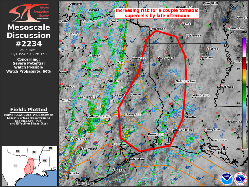
   Mesoscale Discussion 2234
   NWS Storm Prediction Center Norman OK
   1241 PM CST Mon Nov 18 2024

   Areas affected...east TX...western LA...and far southwest AR

   Concerning...Severe potential...Watch possible

   Valid 181841Z - 182045Z

   Probability of Watch Issuance...60 percent

   SUMMARY...Increasing potential for a couple tornadic supercells
   should occur by late afternoon as warm-sector storms intensify ahead
   of a outflow-reinforced cold front. A tornado watch may be needed.

   DISCUSSION...As surface temperatures have warmed into the mid 80s as
   far northeast as the greater Houston Metro Area, warm-sector showers
   have deepened downstream within the warm conveyor across southeast
   TX. A 17Z sounding from Texas A&M at CLL well sampled the
   pre-frontal environment ahead of the outflow-reinforced cold front
   that has been marching east across east TX. While tropospheric lapse
   rates are weak, enhanced low-level shear persists where surface
   winds remain slightly backed ahead of the front (as shown in the 18Z
   LCH/SHV soundings). Surface winds/low-level flow have slowly veered
   farther southwest (where temperatures are warmer) per HGX VWP data,
   suggesting that initial storms might struggle to produce low-level
   mesocyclones until convection spreads farther northeast. The
   undercutting nature of the front will also limit tornado potential
   after passage. The more favorable kinematic/thermodynamic
   environment will probably become centered across the Sabine Valley
   in the next couple hours. This corridor will be monitored for a
   possible tornado watch.

   ..Grams/Smith.. 11/18/2024

   ...Please see www.spc.noaa.gov for graphic product...

   ATTN...WFO...LCH...SHV...HGX...

   LAT...LON   29619439 30039508 30969517 32139442 33149415 33439380
               33259302 32629270 31939266 30609282 29809328 29619439
|
|
Top/All Mesoscale Discussions/Forecast Products/Home
|
|


 @NWSSPC