|
| Mesoscale Discussion 2238 |
|
< Previous MD Next MD >
|
|
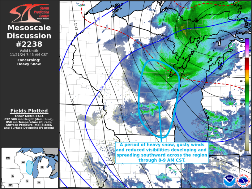
   Mesoscale Discussion 2238
   NWS Storm Prediction Center Norman OK
   0409 AM CST Thu Nov 21 2024

   Areas affected...portions of eastern Wisconsin into adjacent
   northeastern Illinois

   Concerning...Heavy snow

   Valid 211009Z - 211345Z

   SUMMARY...An hour or two period of 1-2+ inch per hour snow rates
   appears possible early this morning, coincident with strong gusty
   winds resulting in blowing snow and reduced visibilities.  This
   appears most likely to spread from near or just west of Green Bay
   southward through the Oshkosh vicinity and areas west of Milwaukee
   by around 8-9 AM CST.

   DISCUSSION...To the southwest of the lingering occluded surface
   cyclone over the upper peninsula of Michigan, sub-freezing
   thermodynamic profiles remain entrenched across much of Wisconsin,
   in the presence of strengthening lower/mid-tropospheric warm
   advection.  This is occurring in advance of a southwestward then
   southward pivoting mid-level cyclonic vorticity center, which is
   forecast to be accompanied by strengthening northerly flow to 50-60
   kt in the 850-700 mb layer across much of eastern Wisconsin.

   Associated strengthening of large-scale ascent is likely to continue
   contributing to saturation of thermodynamic profiles and the
   development of snow through 13-15Z.  Models suggest that lift may
   become strong and focused near and just ahead of the mid-level
   cyclonic vorticity center, maximized within a layer near/above 700
   mb with temperatures around -15C, and conducive to large dendritic
   ice crystal growth.  It appears that this may be accompanied by a
   period of heavy snow rates on the order of 1-2+ inches per hour,
   coincident with strengthening, gusty surface winds.

   ..Kerr.. 11/21/2024

   ...Please see www.spc.noaa.gov for graphic product...

   ATTN...WFO...GRB...LOT...MKX...

   LAT...LON   45018918 44728772 43868764 42428826 43148946 45018918
|
|
Top/All Mesoscale Discussions/Forecast Products/Home
|
|


 @NWSSPC