|
| Mesoscale Discussion 2260 |
|
< Previous MD Next MD >
|
|
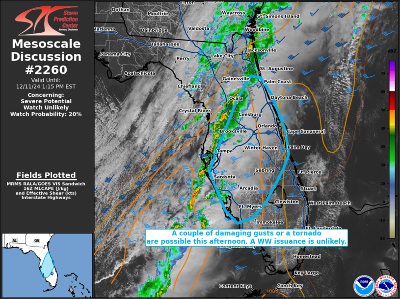
   Mesoscale Discussion 2260
   NWS Storm Prediction Center Norman OK
   1043 AM CST Wed Dec 11 2024

   Areas affected...portions of the central Florida Peninsula

   Concerning...Severe potential...Watch unlikely

   Valid 111643Z - 111815Z

   Probability of Watch Issuance...20 percent

   SUMMARY...Isolated severe gusts and perhaps a tornado cannot be
   ruled out this afternoon. A WW issuance is not expected.

   DISCUSSION...A surface cold front is rapidly approaching the FL
   Peninsula, preceded by a loosely organized QLCS. These storms are
   approaching a gradually destabilizing airmass, where surface
   temperatures are exceeding 80 F amid 70 F dewpoints (supporting 1500
   J/kg MLCAPE). While deep-layer shear and some low-level shear also
   precedes the line, deep-layer ascent will continue to drift away
   from FL, so shear should gradually weaken through the day. However,
   a brief window of opportunity may exist for the buoyancy/shear
   parameter space to briefly coincide to support a couple of damaging
   gusts or a tornado with the stronger updrafts. Nonetheless, the
   severe threat should remain isolated and a WW issuance is unlikely.

   ..Squitieri/Hart.. 12/11/2024

   ...Please see www.spc.noaa.gov for graphic product...

   ATTN...WFO...MFL...MLB...TBW...JAX...

   LAT...LON   27538263 29258190 29798153 29758127 29348096 28538062
               27948052 27618066 26808114 26468147 26328187 26638220
               27538263
|
|
Top/All Mesoscale Discussions/Forecast Products/Home
|
|


 @NWSSPC