|
| Mesoscale Discussion 2261 |
|
< Previous MD Next MD >
|
|
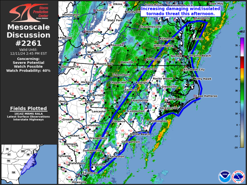
   Mesoscale Discussion 2261
   NWS Storm Prediction Center Norman OK
   1217 PM CST Wed Dec 11 2024

   Areas affected...The Coastal Carolinas into southeast Virginia and
   southeast Maryland

   Concerning...Severe potential...Watch possible

   Valid 111817Z - 111945Z

   Probability of Watch Issuance...40 percent

   SUMMARY...A damaging wind and isolated tornado threat will increase
   this afternoon across the eastern Carolinas into southeast Virginia.

   DISCUSSION...A weakly unstable environment (250-500 J/kg MLCAPE) has
   spread across much of the eastern Carolinas and into far southeast
   Virginia where mid to upper 60s dewpoints are present. Strong ascent
   within strengthening tropospheric flow has kept widespread
   precipitation across much of the warm sector which has limited
   instability. Some weak line segments/bowing segments have developed
   across central North Carolina into southeast Virginia, but it has
   remained mostly sub-severe due to the weak instability. Additional
   line segments are trying to develop along the synoptic front, but
   are embedded within moderate rainfall with minimal instability at
   this time. As the synoptic front sharpens and strengthens more
   through the afternoon and starts to accelerate east, expect
   additional strengthening, perhaps with the front catching up
   to/combining with the ongoing line segments across central North
   Carolina. If/when this occurs is when the primary damaging
   wind/isolated tornado threat is expected this afternoon given the
   very strong tropospheric flow (65 knots at 1km and over 100 knots at
   7km per RAX VWP). Trends will be monitored through the afternoon and
   if a better organized, eastward accelerating convective line becomes
   more apparent this afternoon, a watch may be needed.

   ..Bentley/Hart.. 12/11/2024

   ...Please see www.spc.noaa.gov for graphic product...

   ATTN...WFO...AKQ...MHX...RAH...ILM...CHS...CAE...

   LAT...LON   32547986 32158040 32308070 32728072 34487967 36127832
               37457705 38267596 38337536 38257499 36977584 36497576
               36007549 35597535 35197545 35087579 34797628 34517651
               34637679 34567709 34367752 34067780 33777791 33827817
               33797854 33577885 33347905 33107915 32547986
|
|
Top/All Mesoscale Discussions/Forecast Products/Home
|
|


 @NWSSPC