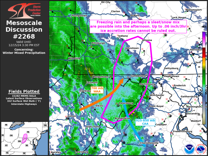
   Mesoscale Discussion 2268
   NWS Storm Prediction Center Norman OK
   0930 AM CST Sun Dec 15 2024

   Areas affected...portions of West Virginia into western Maryland and
   southwestern Pennsylvania

   Concerning...Winter mixed precipitation

   Valid 151530Z - 152030Z

   SUMMARY...Freezing rain should gradually increase into the late
   morning and early afternoon hours, with some sleet or snow also
   possible. Up to .06/3 hr ice accretion rates cannot be ruled out,
   especially in higher-terrain areas.

   DISCUSSION...A pronounced mid-level trough is progressing eastward
   across the OH Valley, encouraging low-level warm air/moisture
   advection over portions of the Appalachians. Here, QG ascent is
   supporting a broad shield of precipitation, which is beginning to
   approach a wedge of sub-freezing low-level temperatures over
   higher-terrain areas. Surface observations from Hardy County, WV to
   Cambria County, PA show temperatures around or below freezing, with
   wet bulb temperatures well below freezing over several locales. 15Z
   mesoanalysis continues to show 925-850 mb CAA over the higher
   terrain, which will further support freezing rain potential, perhaps
   with some sleet or snow mixed in. The best chance for .06/3hr ice
   accretion rates, as well as some sleet or snow, will be late this
   morning into the afternoon hours, as also shown by the latest HRRR
   and HREF probabilistic guidance.

   ..Squitieri.. 12/15/2024

   ...Please see www.spc.noaa.gov for graphic product...

   ATTN...WFO...CTP...LWX...PBZ...RLX...

   LAT...LON   38687964 39297928 39857927 40527896 40647851 40497812
               40037806 39357826 38937852 38677891 38547926 38687964
|


 @NWSSPC