|
| Mesoscale Discussion 2277 |
|
< Previous MD Next MD >
|
|
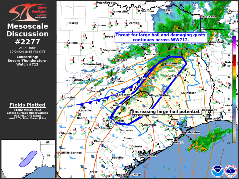
   Mesoscale Discussion 2277
   NWS Storm Prediction Center Norman OK
   0709 PM CST Tue Dec 24 2024

   Areas affected...Portions of central and east/southeast Texas

   Concerning...Severe Thunderstorm Watch 712...

   Valid 250109Z - 250245Z

   The severe weather threat for Severe Thunderstorm Watch 712
   continues.

   SUMMARY...Risk for large hail and damaging gusts continues across
   Severe Thunderstorm Watch 712.

   DISCUSSION...Thunderstorms are increasing in intensity and coverage
   along a northeast/southwest-oriented pre-frontal confluence zone
   draped across central and east/southeast TX this evening. A cold
   front is also approaching from the northwest, and is beginning to
   catch up to the northern portion of the confluence zone. Here,
   congealing outflow is favoring localized upscale growth, and
   damaging winds will be the primary concern. The one exception is a
   persistent semi-discrete supercell ahead of the line which will pose
   a risk of large hail (generally up to 1.5 inches) in the near term.

   Farther south, regional VWP data indicates 30-40 kt of
   west-southwesterly 0-6 km shear, oriented oblique to the pre-frontal
   confluence zone. Given this shear orientation and increased
   separation from the approaching cold front, discrete/semi-discrete
   supercells will pose a risk of large hail (some up to 1.75 inches),
   with damaging winds also possible.

   With time, increasing storm development will favor upscale growth,
   and the severe-wind risk will become the main threat before
   convection gets undercut by the front.

   ..Weinman.. 12/25/2024

   ...Please see www.spc.noaa.gov for graphic product...

   ATTN...WFO...SHV...HGX...FWD...EWX...

   LAT...LON   30879678 31699602 31909576 32079531 32059483 31829466
               30089623 29649707 29709751 29879780 30359748 30879678
|
|
Top/All Mesoscale Discussions/Forecast Products/Home
|
|


 @NWSSPC