|
| Mesoscale Discussion 2299 |
|
< Previous MD Next MD >
|

|
   Mesoscale Discussion 2299
   NWS Storm Prediction Center Norman OK
   1024 AM CST Sat Dec 28 2024

   Areas affected...portions of northern Louisiana into far southern
   Arkansas

   Concerning...Severe Thunderstorm Watch 717...718...

   Valid 281624Z - 281800Z

   The severe weather threat for Severe Thunderstorm Watch 717, 718
   continues.

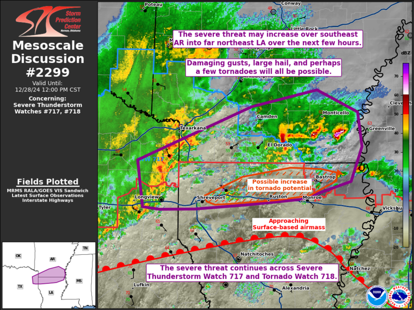
   SUMMARY...The severe threat continues across the remainder of Severe
   Thunderstorm Watch 717 and Tornado Watch 718. In the near term, the
   greatest severe threat will be with a line of storms approaching
   from far northeast TX. The severe threat may increase across
   southeast AR over the next few hours. All severe hazards are
   possible.

   DISCUSSION...A QLCS is rapidly translating eastward amid a mainly
   elevated airmass in place. However, the southernmost portion of this
   QLCS is poised to interact with the warm front and associated
   surface-based airmass (characterized by upper 60s F surface
   dewpoints and 1000+ J/kg MLCAPE). Damaging gusts are the main threat
   with this QLCS in the immediate time frame. However, any interaction
   with the warm front may support in an increase in isolated tornado
   potential over the next couple of hours, especially over far
   northern LA. Latest radar data also shows an increase in
   thunderstorm intensity over far southeast AR, where the QLCS will
   also move toward by afternoon. As such, a WW issuance may eventually
   be needed farther east/northeast of ongoing severe WWs 717-718. All
   severe hazards would be possible.

   ..Squitieri/Hart.. 12/28/2024

   ...Please see www.spc.noaa.gov for graphic product...

   ATTN...WFO...JAN...LZK...SHV...

   LAT...LON   33049468 33759289 33979186 33689121 33229115 32769133
               32529211 32469296 32409378 32399432 32419459 33049468
|
|
Top/All Mesoscale Discussions/Forecast Products/Home
|
|


