Note:
The expiration time in the watch graphic is amended if the watch is
replaced, cancelled or extended.
Note:
Note:
The expiration time in the watch graphic is amended if the watch is
replaced, cancelled or extended.
Note: Click for
Watch Status Reports.
SEL8
URGENT - IMMEDIATE BROADCAST REQUESTED
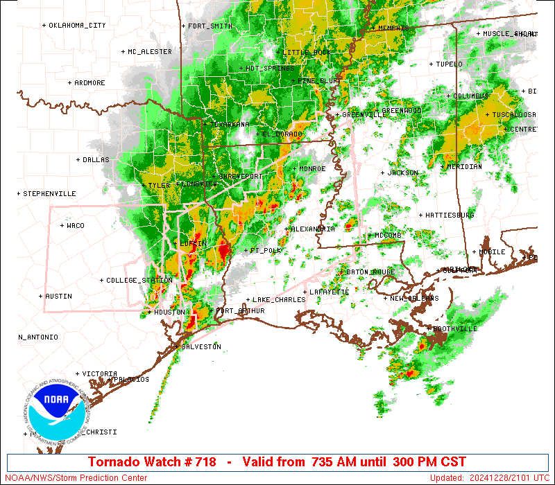
Tornado Watch Number 718
NWS Storm Prediction Center Norman OK
735 AM CST Sat Dec 28 2024
The NWS Storm Prediction Center has issued a
* Tornado Watch for portions of
Louisiana
Southern and central Mississippi
East Texas
* Effective this Saturday morning and afternoon from 735 AM until
300 PM CST.
* Primary threats include...
A few tornadoes likely with a couple intense tornadoes possible
Scattered large hail and isolated very large hail events to 2
inches in diameter possible
Scattered damaging wind gusts to 70 mph possible
SUMMARY...Several regenerative areas of thunderstorms are expected
to form in the warm sector and shift northward to northeastward over
the watch area through early afternoon, with tornadoes, damaging
gusts and sporadic large hail possible. Though the greater
strong-tornado threat may be later this afternoon and evening, a few
are possible in this region, in the meantime.
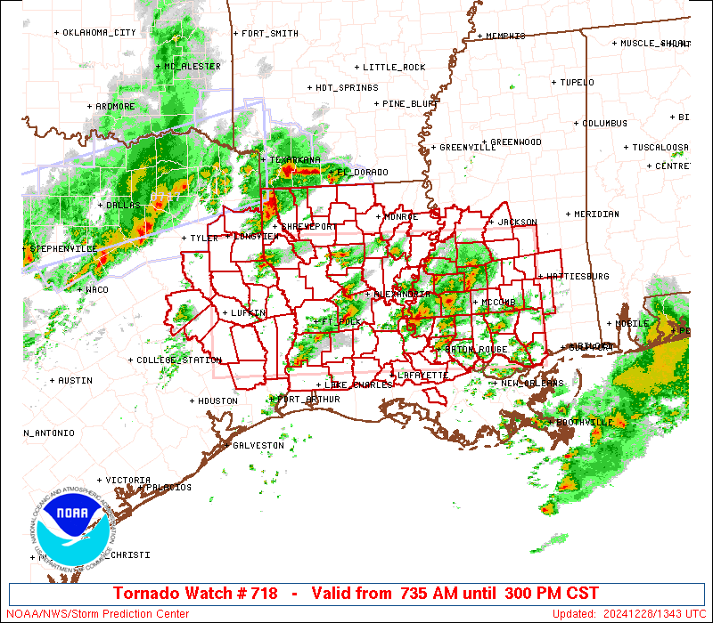
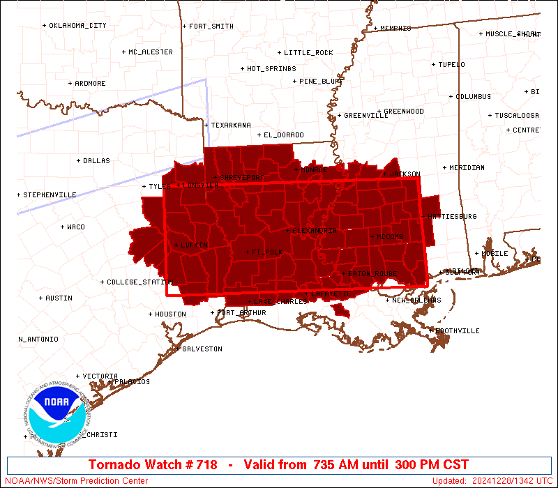
The tornado watch area is approximately along and 70 statute miles
north and south of a line from 15 miles west northwest of Lufkin TX
to 65 miles east of Mc Comb MS. For a complete depiction of the
watch see the associated watch outline update (WOUS64 KWNS WOU8).
PRECAUTIONARY/PREPAREDNESS ACTIONS...
REMEMBER...A Tornado Watch means conditions are favorable for
tornadoes and severe thunderstorms in and close to the watch
area. Persons in these areas should be on the lookout for
threatening weather conditions and listen for later statements
and possible warnings.
&&
OTHER WATCH INFORMATION...CONTINUE...WW 717...
AVIATION...Tornadoes and a few severe thunderstorms with hail
surface and aloft to 2 inches. Extreme turbulence and surface wind
gusts to 60 knots. A few cumulonimbi with maximum tops to 500. Mean
storm motion vector 23025.
...Edwards

   SEL8

   URGENT - IMMEDIATE BROADCAST REQUESTED
   Tornado Watch Number 718
   NWS Storm Prediction Center Norman OK
   735 AM CST Sat Dec 28 2024

   The NWS Storm Prediction Center has issued a

   * Tornado Watch for portions of
     Louisiana
     Southern and central Mississippi
     East Texas

   * Effective this Saturday morning and afternoon from 735 AM until
     300 PM CST.

   * Primary threats include...
     A few tornadoes likely with a couple intense tornadoes possible
     Scattered large hail and isolated very large hail events to 2
       inches in diameter possible
     Scattered damaging wind gusts to 70 mph possible

   SUMMARY...Several regenerative areas of thunderstorms are expected
   to form in the warm sector and shift northward to northeastward over
   the watch area through early afternoon, with tornadoes, damaging
   gusts and sporadic large hail possible.  Though the greater
   strong-tornado threat may be later this afternoon and evening, a few
   are possible in this region, in the meantime.

   The tornado watch area is approximately along and 70 statute miles
   north and south of a line from 15 miles west northwest of Lufkin TX
   to 65 miles east of Mc Comb MS. For a complete depiction of the
   watch see the associated watch outline update (WOUS64 KWNS WOU8).

   PRECAUTIONARY/PREPAREDNESS ACTIONS...

   REMEMBER...A Tornado Watch means conditions are favorable for
   tornadoes and severe thunderstorms in and close to the watch
   area. Persons in these areas should be on the lookout for
   threatening weather conditions and listen for later statements
   and possible warnings.

   &&

   OTHER WATCH INFORMATION...CONTINUE...WW 717...

   AVIATION...Tornadoes and a few severe thunderstorms with hail
   surface and aloft to 2 inches. Extreme turbulence and surface wind
   gusts to 60 knots. A few cumulonimbi with maximum tops to 500. Mean
   storm motion vector 23025.

   ...Edwards
 Note:
The Aviation Watch (SAW) product is an approximation to the watch area.
The actual watch is depicted by the shaded areas.
Note:
The Aviation Watch (SAW) product is an approximation to the watch area.
The actual watch is depicted by the shaded areas.
   SAW8
   WW 718 TORNADO LA MS TX 281335Z - 282100Z
   AXIS..70 STATUTE MILES NORTH AND SOUTH OF LINE..
   15WNW LFK/LUFKIN TX/ - 65E MCB/MC COMB MS/
   ..AVIATION COORDS.. 60NM N/S /16NW LFK - 46E MCB/
   HAIL SURFACE AND ALOFT..2 INCHES. WIND GUSTS..60 KNOTS.
   MAX TOPS TO 500. MEAN STORM MOTION VECTOR 23025.

   LAT...LON 32339498 32188937 30168937 30309498

   THIS IS AN APPROXIMATION TO THE WATCH AREA.  FOR A
   COMPLETE DEPICTION OF THE WATCH SEE WOUS64 KWNS
   FOR WOU8.
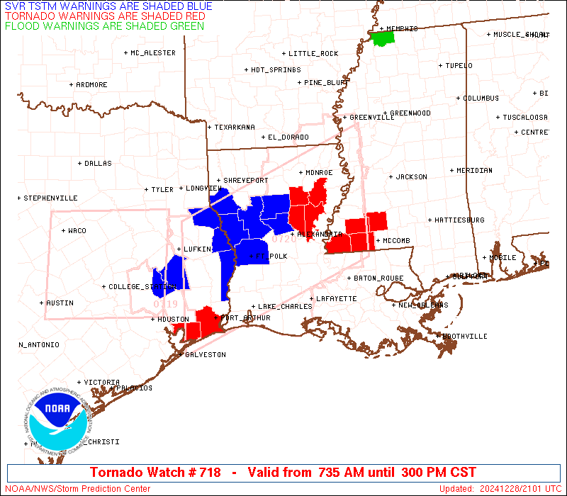
Watch 718 Status Report Messages:
STATUS REPORT #3 ON WW 718
VALID 281840Z - 281940Z
SEVERE WEATHER THREAT CONTINUES RIGHT OF A LINE FROM 20 SE TYR TO
25 SW SHV TO 10 ESE SHV TO 20 WSW ELD.
..WENDT..12/28/24
ATTN...WFO...LCH...LIX...SHV...JAN...HGX...
&&
STATUS REPORT FOR WT 718
SEVERE WEATHER THREAT CONTINUES FOR THE FOLLOWING AREAS
LAC001-003-005-009-011-013-015-019-021-025-027-029-031-033-037-
039-041-043-047-049-053-055-059-061-063-065-069-073-077-079-081-
083-085-091-097-099-103-105-107-111-115-117-119-121-125-127-
281940-
LA
. LOUISIANA PARISHES INCLUDED ARE
ACADIA ALLEN ASCENSION
AVOYELLES BEAUREGARD BIENVILLE
BOSSIER CALCASIEU CALDWELL
CATAHOULA CLAIBORNE CONCORDIA
DE SOTO EAST BATON ROUGE EAST FELICIANA
EVANGELINE FRANKLIN GRANT
IBERVILLE JACKSON JEFFERSON DAVIS
LAFAYETTE LA SALLE LINCOLN
LIVINGSTON MADISON NATCHITOCHES
OUACHITA POINTE COUPEE RAPIDES
RED RIVER RICHLAND SABINE
ST. HELENA ST. LANDRY ST. MARTIN
ST. TAMMANY TANGIPAHOA TENSAS
UNION VERNON WASHINGTON
WEBSTER WEST BATON ROUGE WEST FELICIANA
WINN
$$
MSC001-005-021-029-031-035-037-045-049-063-065-067-073-077-085-
091-109-113-121-127-129-147-149-157-281940-
MS
. MISSISSIPPI COUNTIES INCLUDED ARE
ADAMS AMITE CLAIBORNE
COPIAH COVINGTON FORREST
FRANKLIN HANCOCK HINDS
JEFFERSON JEFFERSON DAVIS JONES
LAMAR LAWRENCE LINCOLN
MARION PEARL RIVER PIKE
RANKIN SIMPSON SMITH
WALTHALL WARREN WILKINSON
$$
TXC005-073-199-225-241-347-351-365-373-401-403-405-419-455-457-
281940-
TX
. TEXAS COUNTIES INCLUDED ARE
ANGELINA CHEROKEE HARDIN
HOUSTON JASPER NACOGDOCHES
NEWTON PANOLA POLK
RUSK SABINE SAN AUGUSTINE
SHELBY TRINITY TYLER
$$
THE WATCH STATUS MESSAGE IS FOR GUIDANCE PURPOSES ONLY. PLEASE
REFER TO WATCH COUNTY NOTIFICATION STATEMENTS FOR OFFICIAL
INFORMATION ON COUNTIES...INDEPENDENT CITIES AND MARINE ZONES
CLEARED FROM SEVERE THUNDERSTORM AND TORNADO WATCHES.
$$
STATUS REPORT #2 ON WW 718
VALID 281730Z - 281840Z
SEVERE WEATHER THREAT CONTINUES RIGHT OF A LINE FROM 20 SE TYR TO
20 ESE GGG TO 15 NW SHV.
..WENDT..12/28/24
ATTN...WFO...LCH...LIX...SHV...JAN...HGX...
&&
STATUS REPORT FOR WT 718
SEVERE WEATHER THREAT CONTINUES FOR THE FOLLOWING AREAS
LAC001-003-005-009-011-013-015-017-019-021-025-027-029-031-033-
037-039-041-043-047-049-053-055-059-061-063-065-069-073-077-079-
081-083-085-091-097-099-103-105-107-111-115-117-119-121-125-127-
281840-
LA
. LOUISIANA PARISHES INCLUDED ARE
ACADIA ALLEN ASCENSION
AVOYELLES BEAUREGARD BIENVILLE
BOSSIER CADDO CALCASIEU
CALDWELL CATAHOULA CLAIBORNE
CONCORDIA DE SOTO EAST BATON ROUGE
EAST FELICIANA EVANGELINE FRANKLIN
GRANT IBERVILLE JACKSON
JEFFERSON DAVIS LAFAYETTE LA SALLE
LINCOLN LIVINGSTON MADISON
NATCHITOCHES OUACHITA POINTE COUPEE
RAPIDES RED RIVER RICHLAND
SABINE ST. HELENA ST. LANDRY
ST. MARTIN ST. TAMMANY TANGIPAHOA
TENSAS UNION VERNON
WASHINGTON WEBSTER WEST BATON ROUGE
WEST FELICIANA WINN
$$
MSC001-005-021-029-031-035-037-045-049-063-065-067-073-077-085-
091-109-113-121-127-129-147-149-157-281840-
MS
. MISSISSIPPI COUNTIES INCLUDED ARE
ADAMS AMITE CLAIBORNE
COPIAH COVINGTON FORREST
FRANKLIN HANCOCK HINDS
JEFFERSON JEFFERSON DAVIS JONES
LAMAR LAWRENCE LINCOLN
MARION PEARL RIVER PIKE
RANKIN SIMPSON SMITH
WALTHALL WARREN WILKINSON
$$
TXC005-073-199-225-241-347-351-365-373-401-403-405-419-455-457-
281840-
TX
. TEXAS COUNTIES INCLUDED ARE
ANGELINA CHEROKEE HARDIN
HOUSTON JASPER NACOGDOCHES
NEWTON PANOLA POLK
RUSK SABINE SAN AUGUSTINE
SHELBY TRINITY TYLER
$$
THE WATCH STATUS MESSAGE IS FOR GUIDANCE PURPOSES ONLY. PLEASE
REFER TO WATCH COUNTY NOTIFICATION STATEMENTS FOR OFFICIAL
INFORMATION ON COUNTIES...INDEPENDENT CITIES AND MARINE ZONES
CLEARED FROM SEVERE THUNDERSTORM AND TORNADO WATCHES.
$$
STATUS REPORT #1 ON WW 718
VALID 281545Z - 281640Z
THE SEVERE WEATHER THREAT CONTINUES ACROSS THE ENTIRE WATCH AREA.
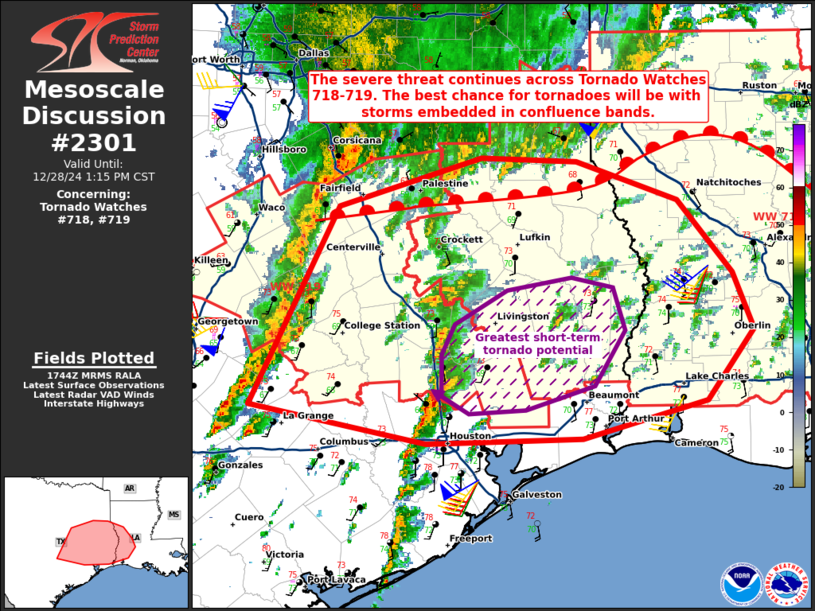
FOR ADDITIONAL INFORMATION SEE MESOSCALE DISCUSSION 2298
..SQUITIERI..12/28/24
ATTN...WFO...LCH...LIX...SHV...JAN...HGX...
&&
STATUS REPORT FOR WT 718
SEVERE WEATHER THREAT CONTINUES FOR THE FOLLOWING AREAS
LAC001-003-005-009-011-013-015-017-019-021-025-027-029-031-033-
037-039-041-043-047-049-053-055-059-061-063-065-069-073-077-079-
081-083-085-091-097-099-103-105-107-111-115-117-119-121-125-127-
281640-
LA
. LOUISIANA PARISHES INCLUDED ARE
ACADIA ALLEN ASCENSION
AVOYELLES BEAUREGARD BIENVILLE
BOSSIER CADDO CALCASIEU
CALDWELL CATAHOULA CLAIBORNE
CONCORDIA DE SOTO EAST BATON ROUGE
EAST FELICIANA EVANGELINE FRANKLIN
GRANT IBERVILLE JACKSON
JEFFERSON DAVIS LAFAYETTE LA SALLE
LINCOLN LIVINGSTON MADISON
NATCHITOCHES OUACHITA POINTE COUPEE
RAPIDES RED RIVER RICHLAND
SABINE ST. HELENA ST. LANDRY
ST. MARTIN ST. TAMMANY TANGIPAHOA
TENSAS UNION VERNON
WASHINGTON WEBSTER WEST BATON ROUGE
WEST FELICIANA WINN
$$
MSC001-005-021-029-031-035-037-045-049-063-065-067-073-077-085-
091-109-113-121-127-129-147-149-157-281640-
MS
. MISSISSIPPI COUNTIES INCLUDED ARE
ADAMS AMITE CLAIBORNE
COPIAH COVINGTON FORREST
FRANKLIN HANCOCK HINDS
JEFFERSON JEFFERSON DAVIS JONES
LAMAR LAWRENCE LINCOLN
MARION PEARL RIVER PIKE
RANKIN SIMPSON SMITH
WALTHALL WARREN WILKINSON
$$
TXC005-073-183-199-203-225-241-347-351-365-373-401-403-405-419-
455-457-281640-
TX
. TEXAS COUNTIES INCLUDED ARE
ANGELINA CHEROKEE GREGG
HARDIN HARRISON HOUSTON
JASPER NACOGDOCHES NEWTON
PANOLA POLK RUSK
SABINE SAN AUGUSTINE SHELBY
TRINITY TYLER
$$
THE WATCH STATUS MESSAGE IS FOR GUIDANCE PURPOSES ONLY. PLEASE
REFER TO WATCH COUNTY NOTIFICATION STATEMENTS FOR OFFICIAL
INFORMATION ON COUNTIES...INDEPENDENT CITIES AND MARINE ZONES
CLEARED FROM SEVERE THUNDERSTORM AND TORNADO WATCHES.
$$
Note:
Click for Complete Product Text.
Tornadoes
Probability of 2 or more tornadoes
|
High (70%)
|
Probability of 1 or more strong (EF2-EF5) tornadoes
|
Mod (50%)
|
Wind
Probability of 10 or more severe wind events
|
Mod (50%)
|
Probability of 1 or more wind events > 65 knots
|
Low (10%)
|
Hail
Probability of 10 or more severe hail events
|
Mod (50%)
|
Probability of 1 or more hailstones > 2 inches
|
Mod (30%)
|
Combined Severe Hail/Wind
Probability of 6 or more combined severe hail/wind events
|
High (80%)
|
For each watch, probabilities for particular events inside the watch
(listed above in each table) are determined by the issuing forecaster.
The "Low" category contains probability values ranging from less than 2%
to 20% (EF2-EF5 tornadoes), less than 5% to 20% (all other probabilities),
"Moderate" from 30% to 60%, and "High" from 70% to greater than 95%.
High values are bolded and lighter in color to provide awareness of
an increased threat for a particular event.


 @NWSSPC