 Note:
The expiration time in the watch graphic is amended if the watch is
replaced, cancelled or extended.
Note:
Note:
The expiration time in the watch graphic is amended if the watch is
replaced, cancelled or extended.
Note: Click for
Watch Status Reports.
SEL9
URGENT - IMMEDIATE BROADCAST REQUESTED
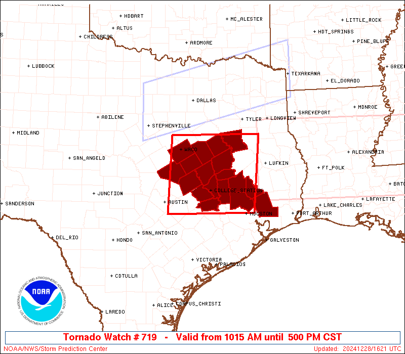
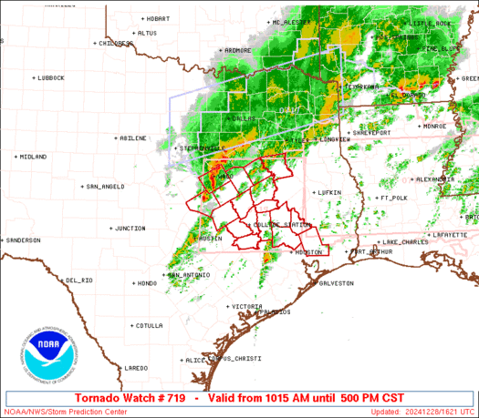
Tornado Watch Number 719
NWS Storm Prediction Center Norman OK
1015 AM CST Sat Dec 28 2024
The NWS Storm Prediction Center has issued a
* Tornado Watch for portions of
Central and Southeast Texas
* Effective this Saturday morning and afternoon from 1015 AM
until 500 PM CST.
* Primary threats include...
A couple tornadoes possible
Scattered large hail likely with isolated very large hail events
to 2 inches in diameter possible
Scattered damaging wind gusts to 70 mph likely
SUMMARY...Thunderstorms will intensify rapidly through the
afternoon, with a few severe storms expected. Large hail and
damaging winds are the main concerns, but a few tornadoes are also
possible later today as winds aloft strengthen.
The tornado watch area is approximately along and 75 statute miles
east and west of a line from 65 miles east northeast of Waco TX to
40 miles south of College Station TX. For a complete depiction of
the watch see the associated watch outline update (WOUS64 KWNS
WOU9).
PRECAUTIONARY/PREPAREDNESS ACTIONS...
REMEMBER...A Tornado Watch means conditions are favorable for
tornadoes and severe thunderstorms in and close to the watch
area. Persons in these areas should be on the lookout for
threatening weather conditions and listen for later statements
and possible warnings.
&&
OTHER WATCH INFORMATION...CONTINUE...WW 717...WW 718...
AVIATION...Tornadoes and a few severe thunderstorms with hail
surface and aloft to 2 inches. Extreme turbulence and surface wind
gusts to 60 knots. A few cumulonimbi with maximum tops to 500. Mean
storm motion vector 23030.
...Hart
   SEL9

   URGENT - IMMEDIATE BROADCAST REQUESTED
   Tornado Watch Number 719
   NWS Storm Prediction Center Norman OK
   1015 AM CST Sat Dec 28 2024

   The NWS Storm Prediction Center has issued a

   * Tornado Watch for portions of
     Central and Southeast Texas

   * Effective this Saturday morning and afternoon from 1015 AM
     until 500 PM CST.

   * Primary threats include...
     A couple tornadoes possible
     Scattered large hail likely with isolated very large hail events
       to 2 inches in diameter possible
     Scattered damaging wind gusts to 70 mph likely

   SUMMARY...Thunderstorms will intensify rapidly through the
   afternoon, with a few severe storms expected.  Large hail and
   damaging winds are the main concerns, but a few tornadoes are also
   possible later today as winds aloft strengthen.

   The tornado watch area is approximately along and 75 statute miles
   east and west of a line from 65 miles east northeast of Waco TX to
   40 miles south of College Station TX. For a complete depiction of
   the watch see the associated watch outline update (WOUS64 KWNS
   WOU9).

   PRECAUTIONARY/PREPAREDNESS ACTIONS...

   REMEMBER...A Tornado Watch means conditions are favorable for
   tornadoes and severe thunderstorms in and close to the watch
   area. Persons in these areas should be on the lookout for
   threatening weather conditions and listen for later statements
   and possible warnings.

   &&

   OTHER WATCH INFORMATION...CONTINUE...WW 717...WW 718...

   AVIATION...Tornadoes and a few severe thunderstorms with hail
   surface and aloft to 2 inches. Extreme turbulence and surface wind
   gusts to 60 knots. A few cumulonimbi with maximum tops to 500. Mean
   storm motion vector 23030.

   ...Hart
 Note:
The Aviation Watch (SAW) product is an approximation to the watch area.
The actual watch is depicted by the shaded areas.
Note:
The Aviation Watch (SAW) product is an approximation to the watch area.
The actual watch is depicted by the shaded areas.
   SAW9
   WW 719 TORNADO TX 281615Z - 282300Z
   AXIS..75 STATUTE MILES EAST AND WEST OF LINE..
   65ENE ACT/WACO TX/ - 40S CLL/COLLEGE STATION TX/
   ..AVIATION COORDS.. 65NM E/W /58ENE ACT - 53W IAH/
   HAIL SURFACE AND ALOFT..2 INCHES. WIND GUSTS..60 KNOTS.
   MAX TOPS TO 500. MEAN STORM MOTION VECTOR 23030.

   LAT...LON 31979493 30009512 30009762 31979748

   THIS IS AN APPROXIMATION TO THE WATCH AREA.  FOR A
   COMPLETE DEPICTION OF THE WATCH SEE WOUS64 KWNS
   FOR WOU9.
Watch 719 Status Report Messages:
STATUS REPORT #2 ON WW 719
VALID 281840Z - 281940Z
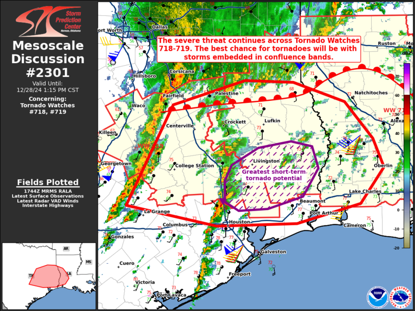
SEVERE WEATHER THREAT CONTINUES RIGHT OF A LINE FROM 40 SE AUS TO
30 WNW CLL TO 15 NE CRS.
..WENDT..12/28/24
ATTN...WFO...FWD...HGX...
&&
STATUS REPORT FOR WT 719
SEVERE WEATHER THREAT CONTINUES FOR THE FOLLOWING AREAS
TXC001-041-051-161-185-289-291-313-339-395-407-471-477-281940-
TX
. TEXAS COUNTIES INCLUDED ARE
ANDERSON BRAZOS BURLESON
FREESTONE GRIMES LEON
LIBERTY MADISON MONTGOMERY
ROBERTSON SAN JACINTO WALKER
WASHINGTON
$$
THE WATCH STATUS MESSAGE IS FOR GUIDANCE PURPOSES ONLY. PLEASE
REFER TO WATCH COUNTY NOTIFICATION STATEMENTS FOR OFFICIAL
INFORMATION ON COUNTIES...INDEPENDENT CITIES AND MARINE ZONES
CLEARED FROM SEVERE THUNDERSTORM AND TORNADO WATCHES.
$$
STATUS REPORT #1 ON WW 719
VALID 281730Z - 281840Z
SEVERE WEATHER THREAT CONTINUES RIGHT OF A LINE FROM 15 S AUS TO
25 WNW CRS.
..WENDT..12/28/24
ATTN...WFO...FWD...HGX...
&&
STATUS REPORT FOR WT 719
SEVERE WEATHER THREAT CONTINUES FOR THE FOLLOWING AREAS
TXC001-041-051-145-161-185-289-291-293-313-331-339-395-407-471-
477-281840-
TX
. TEXAS COUNTIES INCLUDED ARE
ANDERSON BRAZOS BURLESON
FALLS FREESTONE GRIMES
LEON LIBERTY LIMESTONE
MADISON MILAM MONTGOMERY
ROBERTSON SAN JACINTO WALKER
WASHINGTON
$$
THE WATCH STATUS MESSAGE IS FOR GUIDANCE PURPOSES ONLY. PLEASE
REFER TO WATCH COUNTY NOTIFICATION STATEMENTS FOR OFFICIAL
INFORMATION ON COUNTIES...INDEPENDENT CITIES AND MARINE ZONES
CLEARED FROM SEVERE THUNDERSTORM AND TORNADO WATCHES.
$$
Note:
Click for Complete Product Text.
Tornadoes
Probability of 2 or more tornadoes
|
Mod (40%)
|
Probability of 1 or more strong (EF2-EF5) tornadoes
|
Low (20%)
|
Wind
Probability of 10 or more severe wind events
|
Mod (60%)
|
Probability of 1 or more wind events > 65 knots
|
Low (20%)
|
Hail
Probability of 10 or more severe hail events
|
Mod (60%)
|
Probability of 1 or more hailstones > 2 inches
|
Mod (30%)
|
Combined Severe Hail/Wind
Probability of 6 or more combined severe hail/wind events
|
High (>95%)
|
For each watch, probabilities for particular events inside the watch
(listed above in each table) are determined by the issuing forecaster.
The "Low" category contains probability values ranging from less than 2%
to 20% (EF2-EF5 tornadoes), less than 5% to 20% (all other probabilities),
"Moderate" from 30% to 60%, and "High" from 70% to greater than 95%.
High values are bolded and lighter in color to provide awareness of
an increased threat for a particular event.


 @NWSSPC