 Note:
The expiration time in the watch graphic is amended if the watch is
replaced, cancelled or extended.
Note:
Note:
The expiration time in the watch graphic is amended if the watch is
replaced, cancelled or extended.
Note: Click for
Watch Status Reports.
SEL0
URGENT - IMMEDIATE BROADCAST REQUESTED
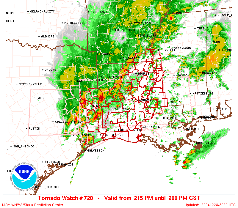
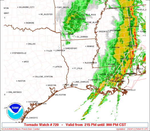
Tornado Watch Number 720
NWS Storm Prediction Center Norman OK
215 PM CST Sat Dec 28 2024
The NWS Storm Prediction Center has issued a
* Tornado Watch for portions of
Southeast Arkansas
Central and Southwest Louisiana
Southwest Mississippi
Southeast Texas
Coastal Waters
* Effective this Saturday afternoon and evening from 215 PM until
900 PM CST.
...THIS IS A PARTICULARLY DANGEROUS SITUATION...
* Primary threats include...
Numerous tornadoes expected with a few intense tornadoes likely
Widespread damaging winds and scattered significant gusts to 80
mph likely
Scattered large hail and isolated very large hail events to 2
inches in diameter possible
SUMMARY...Numerous severe/supercell thunderstorms are expected to
intensify through the afternoon over east Texas and western
Louisiana, spreading rapidly northeastward across the watch through
early evening. Parameters are becoming increasingly favorable for
tornadoes, including strong tornadoes, and widespread damaging winds
through the watch period.
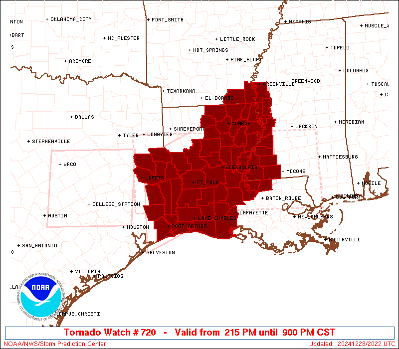
The tornado watch area is approximately along and 85 statute miles
north and south of a line from 55 miles northwest of Port Arthur TX
to 50 miles northeast of Natchez MS. For a complete depiction of the
watch see the associated watch outline update (WOUS64 KWNS WOU0).
PRECAUTIONARY/PREPAREDNESS ACTIONS...
REMEMBER...A Tornado Watch means conditions are favorable for
tornadoes and severe thunderstorms in and close to the watch
area. Persons in these areas should be on the lookout for
threatening weather conditions and listen for later statements
and possible warnings.
&&
OTHER WATCH INFORMATION...CONTINUE...WW 718...WW 719...
AVIATION...Tornadoes and a few severe thunderstorms with hail
surface and aloft to 2 inches. Extreme turbulence and surface wind
gusts to 70 knots. A few cumulonimbi with maximum tops to 500. Mean
storm motion vector 24035.
...Hart

   SEL0

   URGENT - IMMEDIATE BROADCAST REQUESTED
   Tornado Watch Number 720
   NWS Storm Prediction Center Norman OK
   215 PM CST Sat Dec 28 2024

   The NWS Storm Prediction Center has issued a

   * Tornado Watch for portions of
     Southeast Arkansas
     Central and Southwest Louisiana
     Southwest Mississippi
     Southeast Texas
     Coastal Waters

   * Effective this Saturday afternoon and evening from 215 PM until
     900 PM CST.

   ...THIS IS A PARTICULARLY DANGEROUS SITUATION...

   * Primary threats include...
     Numerous tornadoes expected with a few intense tornadoes likely
     Widespread damaging winds and scattered significant gusts to 80
       mph likely
     Scattered large hail and isolated very large hail events to 2
       inches in diameter possible

   SUMMARY...Numerous severe/supercell thunderstorms are expected to
   intensify through the afternoon over east Texas and western
   Louisiana, spreading rapidly northeastward across the watch through
   early evening.  Parameters are becoming increasingly favorable for
   tornadoes, including strong tornadoes, and widespread damaging winds
   through the watch period.

   The tornado watch area is approximately along and 85 statute miles
   north and south of a line from 55 miles northwest of Port Arthur TX
   to 50 miles northeast of Natchez MS. For a complete depiction of the
   watch see the associated watch outline update (WOUS64 KWNS WOU0).

   PRECAUTIONARY/PREPAREDNESS ACTIONS...

   REMEMBER...A Tornado Watch means conditions are favorable for
   tornadoes and severe thunderstorms in and close to the watch
   area. Persons in these areas should be on the lookout for
   threatening weather conditions and listen for later statements
   and possible warnings.

   &&

   OTHER WATCH INFORMATION...CONTINUE...WW 718...WW 719...

   AVIATION...Tornadoes and a few severe thunderstorms with hail
   surface and aloft to 2 inches. Extreme turbulence and surface wind
   gusts to 70 knots. A few cumulonimbi with maximum tops to 500. Mean
   storm motion vector 24035.

   ...Hart
 Note:
The Aviation Watch (SAW) product is an approximation to the watch area.
The actual watch is depicted by the shaded areas.
Note:
The Aviation Watch (SAW) product is an approximation to the watch area.
The actual watch is depicted by the shaded areas.
   SAW0
   WW 720 TORNADO AR LA MS TX CW 282015Z - 290300Z
   AXIS..85 STATUTE MILES NORTH AND SOUTH OF LINE..
   55NW BPT/PORT ARTHUR TX/ - 50NE HEZ/NATCHEZ MS/
   ..AVIATION COORDS.. 75NM N/S /39S LFK - 35WSW MHZ/
   HAIL SURFACE AND ALOFT..2 INCHES. WIND GUSTS..70 KNOTS.
   MAX TOPS TO 500. MEAN STORM MOTION VECTOR 24035.

   LAT...LON 31749467 33369070 30909070 29289467

   THIS IS AN APPROXIMATION TO THE WATCH AREA.  FOR A
   COMPLETE DEPICTION OF THE WATCH SEE WOUS64 KWNS
   FOR WOU0.
Watch 720 Status Report Messages:
STATUS REPORT #6 ON WW 720
VALID 290225Z - 290300Z
SEVERE WEATHER THREAT CONTINUES RIGHT OF A LINE FROM 30 SSW 7R4
TO 35 E LFT TO 15 ESE MCB TO 25 SE LLQ.
WW 720 WILL BE ALLOWED TO EXPIRE AT 290300Z.
..THORNTON..12/29/24
ATTN...WFO...JAN...LCH...SHV...LIX...
&&
STATUS REPORT FOR WT 720
SEVERE WEATHER THREAT CONTINUES FOR THE FOLLOWING AREAS
LAC005-045-063-101-105-117-290300-
LA
. LOUISIANA PARISHES INCLUDED ARE
ASCENSION IBERIA LIVINGSTON
ST. MARY TANGIPAHOA WASHINGTON
$$
MSC019-023-025-031-035-061-065-067-069-073-075-087-091-099-101-
103-105-147-155-159-290300-
MS
. MISSISSIPPI COUNTIES INCLUDED ARE
CHOCTAW CLARKE CLAY
COVINGTON FORREST JASPER
JEFFERSON DAVIS JONES KEMPER
LAMAR LAUDERDALE LOWNDES
MARION NESHOBA NEWTON
NOXUBEE OKTIBBEHA WALTHALL
WEBSTER WINSTON
$$
GMZ435-436-290300-
CW
. ADJACENT COASTAL WATERS INCLUDED ARE
VERMILION BAY
$$
THE WATCH STATUS MESSAGE IS FOR GUIDANCE PURPOSES ONLY. PLEASE
REFER TO WATCH COUNTY NOTIFICATION STATEMENTS FOR OFFICIAL
INFORMATION ON COUNTIES...INDEPENDENT CITIES AND MARINE ZONES
CLEARED FROM SEVERE THUNDERSTORM AND TORNADO WATCHES.
$$
STATUS REPORT #5 ON WW 720
VALID 290145Z - 290240Z
SEVERE WEATHER THREAT CONTINUES RIGHT OF A LINE FROM 50 SSE LCH
TO 5 ENE LFT TO 10 NNW MCB.
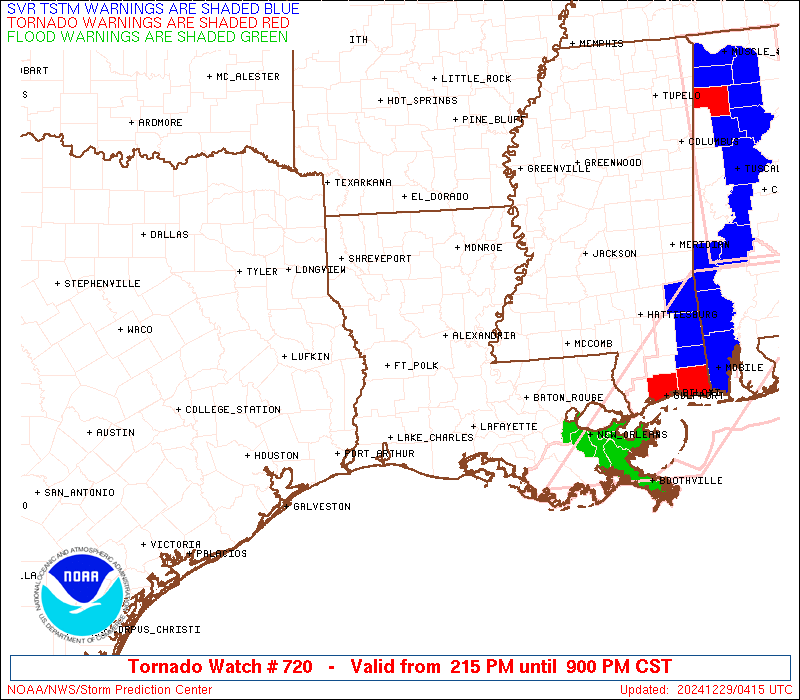
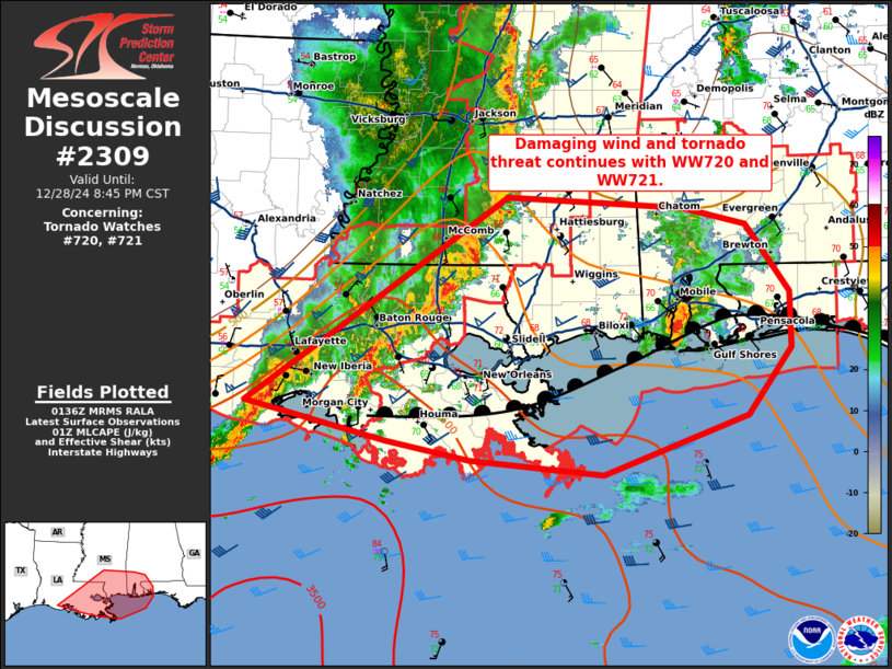
FOR ADDITIONAL INFORMATION SEE MESOSCALE DISCUSSION 2309
..THORNTON..12/29/24
ATTN...WFO...JAN...LCH...SHV...LIX...
&&
STATUS REPORT FOR WT 720
SEVERE WEATHER THREAT CONTINUES FOR THE FOLLOWING AREAS
LAC005-033-045-047-063-091-099-101-105-113-117-121-290240-
LA
. LOUISIANA PARISHES INCLUDED ARE
ASCENSION EAST BATON ROUGE IBERIA
IBERVILLE LIVINGSTON ST. HELENA
ST. MARTIN ST. MARY TANGIPAHOA
VERMILION WASHINGTON WEST BATON ROUGE
$$
MSC007-015-019-023-025-031-035-043-051-061-065-067-069-073-075-
077-079-087-089-091-097-099-101-103-105-113-121-123-127-129-147-
155-159-290240-
MS
. MISSISSIPPI COUNTIES INCLUDED ARE
ATTALA CARROLL CHOCTAW
CLARKE CLAY COVINGTON
FORREST GRENADA HOLMES
JASPER JEFFERSON DAVIS JONES
KEMPER LAMAR LAUDERDALE
LAWRENCE LEAKE LOWNDES
MADISON MARION MONTGOMERY
NESHOBA NEWTON NOXUBEE
OKTIBBEHA PIKE RANKIN
SCOTT SIMPSON SMITH
WALTHALL WEBSTER WINSTON
$$
GMZ435-436-290240-
CW
. ADJACENT COASTAL WATERS INCLUDED ARE
VERMILION BAY
$$
THE WATCH STATUS MESSAGE IS FOR GUIDANCE PURPOSES ONLY. PLEASE
REFER TO WATCH COUNTY NOTIFICATION STATEMENTS FOR OFFICIAL
INFORMATION ON COUNTIES...INDEPENDENT CITIES AND MARINE ZONES
CLEARED FROM SEVERE THUNDERSTORM AND TORNADO WATCHES.
$$
STATUS REPORT #4 ON WW 720
VALID 290040Z - 290140Z
SEVERE WEATHER THREAT CONTINUES RIGHT OF A LINE FROM 45 SSW LCH
TO 40 NNW LFT TO 10 SE HEZ TO 60 NE HEZ TO 20 NE GLH.
FOR ADDITIONAL INFORMATION SEE MESOSCALE DISCUSSION 2307
..THORNTON..12/29/24
ATTN...WFO...JAN...LCH...SHV...LIX...
&&
STATUS REPORT FOR WT 720
SEVERE WEATHER THREAT CONTINUES FOR THE FOLLOWING AREAS
LAC001-005-023-033-037-045-047-055-063-077-091-097-099-101-105-
113-117-121-125-290140-
LA
. LOUISIANA PARISHES INCLUDED ARE
ACADIA ASCENSION CAMERON
EAST BATON ROUGE EAST FELICIANA IBERIA
IBERVILLE LAFAYETTE LIVINGSTON
POINTE COUPEE ST. HELENA ST. LANDRY
ST. MARTIN ST. MARY TANGIPAHOA
VERMILION WASHINGTON WEST BATON ROUGE
WEST FELICIANA
$$
MSC005-007-015-019-029-031-037-043-049-051-053-063-065-077-079-
083-085-089-091-097-113-121-123-127-129-147-155-157-163-
290140-
MS
. MISSISSIPPI COUNTIES INCLUDED ARE
AMITE ATTALA CARROLL
CHOCTAW COPIAH COVINGTON
FRANKLIN GRENADA HINDS
HOLMES HUMPHREYS JEFFERSON
JEFFERSON DAVIS LAWRENCE LEAKE
LEFLORE LINCOLN MADISON
MARION MONTGOMERY PIKE
RANKIN SCOTT SIMPSON
SMITH WALTHALL WEBSTER
WILKINSON YAZOO
$$
GMZ435-436-290140-
CW
. ADJACENT COASTAL WATERS INCLUDED ARE
VERMILION BAY
$$
THE WATCH STATUS MESSAGE IS FOR GUIDANCE PURPOSES ONLY. PLEASE
REFER TO WATCH COUNTY NOTIFICATION STATEMENTS FOR OFFICIAL
INFORMATION ON COUNTIES...INDEPENDENT CITIES AND MARINE ZONES
CLEARED FROM SEVERE THUNDERSTORM AND TORNADO WATCHES.
$$
STATUS REPORT #3 ON WW 720
VALID 282340Z - 290040Z
SEVERE WEATHER THREAT CONTINUES RIGHT OF A LINE FROM 20 NE HOU TO
30 SSE POE TO 20 E ESF TO 10 E GLH.
FOR ADDITIONAL INFORMATION SEE MESOSCALE DISCUSSION 2306
..THORNTON..12/28/24
ATTN...WFO...JAN...LCH...SHV...LIX...
&&
STATUS REPORT FOR WT 720
SEVERE WEATHER THREAT CONTINUES FOR THE FOLLOWING AREAS
LAC001-003-005-009-011-019-023-029-033-037-039-047-053-055-063-
065-077-091-097-105-107-113-117-121-125-290040-
LA
. LOUISIANA PARISHES INCLUDED ARE
ACADIA ALLEN ASCENSION
AVOYELLES BEAUREGARD CALCASIEU
CAMERON CONCORDIA EAST BATON ROUGE
EAST FELICIANA EVANGELINE IBERVILLE
JEFFERSON DAVIS LAFAYETTE LIVINGSTON
MADISON POINTE COUPEE ST. HELENA
ST. LANDRY TANGIPAHOA TENSAS
VERMILION WASHINGTON WEST BATON ROUGE
WEST FELICIANA
$$
MSC001-005-007-015-019-021-029-031-037-043-049-051-053-055-063-
065-077-079-083-085-089-091-097-113-121-123-125-127-129-147-149-
155-157-163-290040-
MS
. MISSISSIPPI COUNTIES INCLUDED ARE
ADAMS AMITE ATTALA
CARROLL CHOCTAW CLAIBORNE
COPIAH COVINGTON FRANKLIN
GRENADA HINDS HOLMES
HUMPHREYS ISSAQUENA JEFFERSON
JEFFERSON DAVIS LAWRENCE LEAKE
LEFLORE LINCOLN MADISON
MARION MONTGOMERY PIKE
RANKIN SCOTT SHARKEY
SIMPSON SMITH WALTHALL
WARREN WEBSTER WILKINSON
YAZOO
$$
TXC245-361-290040-
TX
. TEXAS COUNTIES INCLUDED ARE
JEFFERSON ORANGE
$$
GMZ430-432-290040-
CW
. ADJACENT COASTAL WATERS INCLUDED ARE
SABINE LAKE
CALCASIEU LAKE
$$
THE WATCH STATUS MESSAGE IS FOR GUIDANCE PURPOSES ONLY. PLEASE
REFER TO WATCH COUNTY NOTIFICATION STATEMENTS FOR OFFICIAL
INFORMATION ON COUNTIES...INDEPENDENT CITIES AND MARINE ZONES
CLEARED FROM SEVERE THUNDERSTORM AND TORNADO WATCHES.
$$
STATUS REPORT #2 ON WW 720
VALID 282235Z - 282340Z
SEVERE WEATHER THREAT CONTINUES RIGHT OF A LINE FROM 45 WNW BPT
TO 30 S MLU TO 45 NE MLU.
..SPC..12/28/24
ATTN...WFO...JAN...LCH...SHV...LIX...
&&
STATUS REPORT FOR WT 720
SEVERE WEATHER THREAT CONTINUES FOR THE FOLLOWING AREAS
LAC001-003-009-011-019-021-023-025-029-035-037-039-041-043-053-
055-059-065-077-079-083-097-107-113-115-123-125-282340-
LA
. LOUISIANA PARISHES INCLUDED ARE
ACADIA ALLEN AVOYELLES
BEAUREGARD CALCASIEU CALDWELL
CAMERON CATAHOULA CONCORDIA
EAST CARROLL EAST FELICIANA EVANGELINE
FRANKLIN GRANT JEFFERSON DAVIS
LAFAYETTE LA SALLE MADISON
POINTE COUPEE RAPIDES RICHLAND
ST. LANDRY TENSAS VERMILION
VERNON WEST CARROLL WEST FELICIANA
$$
MSC001-005-021-029-037-049-055-063-077-085-089-121-125-127-149-
151-157-163-282340-
MS
. MISSISSIPPI COUNTIES INCLUDED ARE
ADAMS AMITE CLAIBORNE
COPIAH FRANKLIN HINDS
ISSAQUENA JEFFERSON LAWRENCE
LINCOLN MADISON RANKIN
SHARKEY SIMPSON WARREN
WASHINGTON WILKINSON YAZOO
$$
TXC199-241-245-351-361-457-282340-
TX
. TEXAS COUNTIES INCLUDED ARE
HARDIN JASPER JEFFERSON
NEWTON ORANGE TYLER
$$
GMZ430-432-282340-
CW
. ADJACENT COASTAL WATERS INCLUDED ARE
SABINE LAKE
CALCASIEU LAKE
$$
THE WATCH STATUS MESSAGE IS FOR GUIDANCE PURPOSES ONLY. PLEASE
REFER TO WATCH COUNTY NOTIFICATION STATEMENTS FOR OFFICIAL
INFORMATION ON COUNTIES...INDEPENDENT CITIES AND MARINE ZONES
CLEARED FROM SEVERE THUNDERSTORM AND TORNADO WATCHES.
$$
STATUS REPORT #1 ON WW 720
VALID 282155Z - 282240Z
SEVERE WEATHER THREAT CONTINUES RIGHT OF A LINE FROM 15 SSW LFK
TO 15 SW IER TO 40 SW MLU TO 40 N MLU.
..WENDT..12/28/24
ATTN...WFO...JAN...LCH...SHV...LIX...
&&
STATUS REPORT FOR WT 720
SEVERE WEATHER THREAT CONTINUES FOR THE FOLLOWING AREAS
ARC003-017-282240-
AR
. ARKANSAS COUNTIES INCLUDED ARE
ASHLEY CHICOT
$$
LAC001-003-009-011-019-021-023-025-029-035-037-039-041-043-053-
055-059-065-067-069-073-077-079-083-085-097-107-113-115-123-125-
127-282240-
LA
. LOUISIANA PARISHES INCLUDED ARE
ACADIA ALLEN AVOYELLES
BEAUREGARD CALCASIEU CALDWELL
CAMERON CATAHOULA CONCORDIA
EAST CARROLL EAST FELICIANA EVANGELINE
FRANKLIN GRANT JEFFERSON DAVIS
LAFAYETTE LA SALLE MADISON
MOREHOUSE NATCHITOCHES OUACHITA
POINTE COUPEE RAPIDES RICHLAND
SABINE ST. LANDRY TENSAS
VERMILION VERNON WEST CARROLL
WEST FELICIANA WINN
$$
MSC001-005-021-029-037-049-055-063-077-085-089-121-125-127-149-
151-157-163-282240-
MS
. MISSISSIPPI COUNTIES INCLUDED ARE
ADAMS AMITE CLAIBORNE
COPIAH FRANKLIN HINDS
ISSAQUENA JEFFERSON LAWRENCE
LINCOLN MADISON RANKIN
SHARKEY SIMPSON WARREN
WASHINGTON WILKINSON YAZOO
$$
TXC199-241-245-351-361-403-457-282240-
TX
. TEXAS COUNTIES INCLUDED ARE
HARDIN JASPER JEFFERSON
NEWTON ORANGE SABINE
TYLER
$$
GMZ430-432-282240-
CW
. ADJACENT COASTAL WATERS INCLUDED ARE
SABINE LAKE
CALCASIEU LAKE
$$
THE WATCH STATUS MESSAGE IS FOR GUIDANCE PURPOSES ONLY. PLEASE
REFER TO WATCH COUNTY NOTIFICATION STATEMENTS FOR OFFICIAL
INFORMATION ON COUNTIES...INDEPENDENT CITIES AND MARINE ZONES
CLEARED FROM SEVERE THUNDERSTORM AND TORNADO WATCHES.
$$
Note:
Click for Complete Product Text.
Tornadoes
Probability of 2 or more tornadoes
|
High (>95%)
|
Probability of 1 or more strong (EF2-EF5) tornadoes
|
High (80%)
|
Wind
Probability of 10 or more severe wind events
|
High (90%)
|
Probability of 1 or more wind events > 65 knots
|
High (80%)
|
Hail
Probability of 10 or more severe hail events
|
Mod (40%)
|
Probability of 1 or more hailstones > 2 inches
|
Mod (30%)
|
Combined Severe Hail/Wind
Probability of 6 or more combined severe hail/wind events
|
High (>95%)
|
For each watch, probabilities for particular events inside the watch
(listed above in each table) are determined by the issuing forecaster.
The "Low" category contains probability values ranging from less than 2%
to 20% (EF2-EF5 tornadoes), less than 5% to 20% (all other probabilities),
"Moderate" from 30% to 60%, and "High" from 70% to greater than 95%.
High values are bolded and lighter in color to provide awareness of
an increased threat for a particular event.


 @NWSSPC