 Note:
The expiration time in the watch graphic is amended if the watch is
replaced, cancelled or extended.
Note:
Note:
The expiration time in the watch graphic is amended if the watch is
replaced, cancelled or extended.
Note: Click for
Watch Status Reports.
SEL1
URGENT - IMMEDIATE BROADCAST REQUESTED
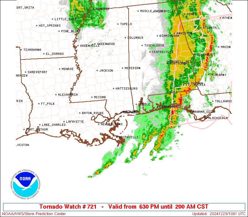
Tornado Watch Number 721
NWS Storm Prediction Center Norman OK
630 PM CST Sat Dec 28 2024
The NWS Storm Prediction Center has issued a
* Tornado Watch for portions of
Southern Alabama
The Western Florida Panhandle
Southeast Louisiana
Southern Mississippi
Coastal Waters
* Effective this Saturday night and Sunday morning from 630 PM
until 200 AM CST.
* Primary threats include...
Several tornadoes likely with a couple intense tornadoes
possible
Scattered damaging winds likely with isolated significant gusts
to 80 mph possible
Isolated large hail events to 1.5 inches in diameter possible
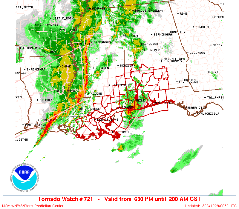
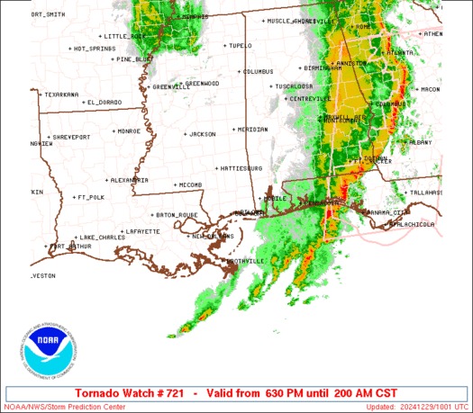
SUMMARY...Thunderstorms will continue to pose a threat for tornadoes
and severe/damaging winds this evening and overnight. The most
intense winds may reach 70-80 mph within the developing line of
thunderstorms. A strong tornado also appears possible with any
sustained supercell that can be maintained ahead of the line.
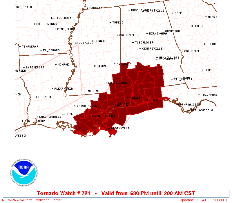
The tornado watch area is approximately along and 70 statute miles
east and west of a line from 40 miles north northwest of Evergreen
AL to 70 miles south of Slidell LA. For a complete depiction of the
watch see the associated watch outline update (WOUS64 KWNS WOU1).
PRECAUTIONARY/PREPAREDNESS ACTIONS...
REMEMBER...A Tornado Watch means conditions are favorable for
tornadoes and severe thunderstorms in and close to the watch
area. Persons in these areas should be on the lookout for
threatening weather conditions and listen for later statements
and possible warnings.
&&
OTHER WATCH INFORMATION...CONTINUE...WW 720...
AVIATION...Tornadoes and a few severe thunderstorms with hail
surface and aloft to 1.5 inches. Extreme turbulence and surface wind
gusts to 70 knots. A few cumulonimbi with maximum tops to 500. Mean
storm motion vector 26040.
...Gleason
 Note:
The Aviation Watch (SAW) product is an approximation to the watch area.
The actual watch is depicted by the shaded areas.
Note:
The Aviation Watch (SAW) product is an approximation to the watch area.
The actual watch is depicted by the shaded areas.
   SAW1
   WW 721 TORNADO AL FL LA MS CW 290030Z - 290800Z
   AXIS..70 STATUTE MILES EAST AND WEST OF LINE..
   40NNW GZH/EVERGREEN AL/ - 70S ASD/SLIDELL LA/
   ..AVIATION COORDS.. 60NM E/W /52WSW MGM - 17ENE LEV/
   HAIL SURFACE AND ALOFT..1.5 INCHES. WIND GUSTS..70 KNOTS.
   MAX TOPS TO 500. MEAN STORM MOTION VECTOR 26040.

   LAT...LON 31958611 29338866 29339098 31958850

   THIS IS AN APPROXIMATION TO THE WATCH AREA.  FOR A
   COMPLETE DEPICTION OF THE WATCH SEE WOUS64 KWNS
   FOR WOU1.
Watch 721 Status Report Messages:
STATUS REPORT #7 ON WW 721

VALID 290735Z - 290840Z

SEVERE WEATHER THREAT CONTINUES RIGHT OF A LINE FROM 30 E BVE TO
10 WNW TOI.

..GRAMS..12/29/24

ATTN...WFO...MOB...LIX...

&&

STATUS REPORT FOR WT 721

SEVERE WEATHER THREAT CONTINUES FOR THE FOLLOWING AREAS

ALC039-041-053-290840-

AL
.    ALABAMA COUNTIES INCLUDED ARE

COVINGTON	     CRENSHAW		 ESCAMBIA
$$


FLC033-091-113-290840-

FL
.    FLORIDA COUNTIES INCLUDED ARE

ESCAMBIA	     OKALOOSA		 SANTA ROSA
$$


GMZ633-634-635-636-650-655-290840-

CW

.    ADJACENT COASTAL WATERS INCLUDED ARE

PERDIDO BAY AREA

PENSACOLA BAY AREA INCLUDING SANTA ROSA SOUND

WESTERN CHOCTAWHATCHEE BAY

EASTERN CHOCTAWHATCHEE BAY

COASTAL WATERS FROM PENSACOLA FL TO PASCAGOULA MS OUT 20 NM

COASTAL WATERS FROM OKALOOSA-WALTON COUNTY LINE TO PENSACOLA FL
OUT 20 NM

$$
THE WATCH STATUS MESSAGE IS FOR GUIDANCE PURPOSES ONLY.  PLEASE
REFER TO WATCH COUNTY NOTIFICATION STATEMENTS FOR OFFICIAL
INFORMATION ON COUNTIES...INDEPENDENT CITIES AND MARINE ZONES
CLEARED FROM SEVERE THUNDERSTORM AND TORNADO WATCHES.
$$

STATUS REPORT #6 ON WW 721

VALID 290635Z - 290740Z

SEVERE WEATHER THREAT CONTINUES RIGHT OF A LINE FROM 25 W BVE TO
15 E MOB TO 30 SSE SEM.

FOR ADDITIONAL INFORMATION SEE MESOSCALE DISCUSSION 2312.

..GRAMS..12/29/24

ATTN...WFO...MOB...LIX...

&&

STATUS REPORT FOR WT 721

SEVERE WEATHER THREAT CONTINUES FOR THE FOLLOWING AREAS

ALC003-013-035-039-041-053-290740-

AL
.    ALABAMA COUNTIES INCLUDED ARE

BALDWIN 	     BUTLER		 CONECUH
COVINGTON	     CRENSHAW		 ESCAMBIA
$$


FLC033-091-113-290740-

FL
.    FLORIDA COUNTIES INCLUDED ARE

ESCAMBIA	     OKALOOSA		 SANTA ROSA
$$


LAC075-290740-

LA
.    LOUISIANA PARISHES INCLUDED ARE

PLAQUEMINES
$$


GMZ536-538-557-630-631-632-633-634-635-636-650-655-290740-

CW

.    ADJACENT COASTAL WATERS INCLUDED ARE

CHANDELEUR SOUND

BRETON SOUND

COASTAL WATERS FROM PASCAGOULA MISSISSIPPI TO STAKE ISLAND OUT 20
NM

NORTH MOBILE BAY

SOUTH MOBILE BAY

MISSISSIPPI SOUND

PERDIDO BAY AREA

PENSACOLA BAY AREA INCLUDING SANTA ROSA SOUND

WESTERN CHOCTAWHATCHEE BAY

EASTERN CHOCTAWHATCHEE BAY

COASTAL WATERS FROM PENSACOLA FL TO PASCAGOULA MS OUT 20 NM

COASTAL WATERS FROM OKALOOSA-WALTON COUNTY LINE TO PENSACOLA FL
OUT 20 NM

$$
THE WATCH STATUS MESSAGE IS FOR GUIDANCE PURPOSES ONLY.  PLEASE
REFER TO WATCH COUNTY NOTIFICATION STATEMENTS FOR OFFICIAL
INFORMATION ON COUNTIES...INDEPENDENT CITIES AND MARINE ZONES
CLEARED FROM SEVERE THUNDERSTORM AND TORNADO WATCHES.
$$

STATUS REPORT #5 ON WW 721

VALID 290515Z - 290640Z

SEVERE WEATHER THREAT CONTINUES RIGHT OF A LINE FROM 35 SW HUM TO
30 SSE MSY TO 25 SSW GPT TO 20 NW MOB TO 35 NW GZH TO 10 SW SEM.

FOR ADDITIONAL INFORMATION SEE MESOSCALE DISCUSSION 2311

..THORNTON..12/29/24

ATTN...WFO...MOB...LIX...

&&

STATUS REPORT FOR WT 721

SEVERE WEATHER THREAT CONTINUES FOR THE FOLLOWING AREAS

ALC003-013-035-039-041-053-097-099-290640-

AL
.    ALABAMA COUNTIES INCLUDED ARE

BALDWIN 	     BUTLER		 CONECUH
COVINGTON	     CRENSHAW		 ESCAMBIA
MOBILE		     MONROE
$$


FLC033-091-113-290640-

FL
.    FLORIDA COUNTIES INCLUDED ARE

ESCAMBIA	     OKALOOSA		 SANTA ROSA
$$


LAC075-290640-

LA
.    LOUISIANA PARISHES INCLUDED ARE

PLAQUEMINES
$$


MSC059-290640-

MS
.    MISSISSIPPI COUNTIES INCLUDED ARE

JACKSON
$$


GMZ532-536-538-557-630-631-632-633-634-635-636-650-655-290640-

CW

.    ADJACENT COASTAL WATERS INCLUDED ARE

MISSISSIPPI SOUND

CHANDELEUR SOUND

BRETON SOUND

COASTAL WATERS FROM PASCAGOULA MISSISSIPPI TO STAKE ISLAND OUT 20
NM

NORTH MOBILE BAY

SOUTH MOBILE BAY

MISSISSIPPI SOUND

PERDIDO BAY AREA

PENSACOLA BAY AREA INCLUDING SANTA ROSA SOUND

WESTERN CHOCTAWHATCHEE BAY

EASTERN CHOCTAWHATCHEE BAY

COASTAL WATERS FROM PENSACOLA FL TO PASCAGOULA MS OUT 20 NM

COASTAL WATERS FROM OKALOOSA-WALTON COUNTY LINE TO PENSACOLA FL
OUT 20 NM

$$
THE WATCH STATUS MESSAGE IS FOR GUIDANCE PURPOSES ONLY.  PLEASE
REFER TO WATCH COUNTY NOTIFICATION STATEMENTS FOR OFFICIAL
INFORMATION ON COUNTIES...INDEPENDENT CITIES AND MARINE ZONES
CLEARED FROM SEVERE THUNDERSTORM AND TORNADO WATCHES.
$$

STATUS REPORT #4 ON WW 721

VALID 290425Z - 290540Z

THE SEVERE WEATHER THREAT CONTINUES ACROSS THE ENTIRE WATCH AREA.

FOR ADDITIONAL INFORMATION SEE MESOSCALE DISCUSSION 2311

..THORNTON..12/29/24

ATTN...WFO...MOB...LIX...

&&

STATUS REPORT FOR WT 721

SEVERE WEATHER THREAT CONTINUES FOR THE FOLLOWING AREAS

ALC003-013-023-025-035-039-041-053-097-099-129-131-290540-

AL
.    ALABAMA COUNTIES INCLUDED ARE

BALDWIN 	     BUTLER		 CHOCTAW
CLARKE		     CONECUH		 COVINGTON
CRENSHAW	     ESCAMBIA		 MOBILE
MONROE		     WASHINGTON 	 WILCOX
$$


FLC033-091-113-290540-

FL
.    FLORIDA COUNTIES INCLUDED ARE

ESCAMBIA	     OKALOOSA		 SANTA ROSA
$$


LAC051-057-071-075-087-089-109-290540-

LA
.    LOUISIANA PARISHES INCLUDED ARE

JEFFERSON	     LAFOURCHE		 ORLEANS
PLAQUEMINES	     ST. BERNARD	 ST. CHARLES
TERREBONNE
$$


MSC039-041-045-047-059-111-131-153-290540-

MS
.    MISSISSIPPI COUNTIES INCLUDED ARE

GEORGE		     GREENE		 HANCOCK
HARRISON	     JACKSON		 PERRY
STONE		     WAYNE
$$


GMZ532-534-536-538-557-630-631-632-633-634-635-636-650-655-
290540-

CW

.    ADJACENT COASTAL WATERS INCLUDED ARE

MISSISSIPPI SOUND

LAKE BORGNE

CHANDELEUR SOUND

BRETON SOUND

COASTAL WATERS FROM PASCAGOULA MISSISSIPPI TO STAKE ISLAND OUT 20
NM

NORTH MOBILE BAY

SOUTH MOBILE BAY

MISSISSIPPI SOUND

PERDIDO BAY AREA

PENSACOLA BAY AREA INCLUDING SANTA ROSA SOUND

WESTERN CHOCTAWHATCHEE BAY

EASTERN CHOCTAWHATCHEE BAY

COASTAL WATERS FROM PENSACOLA FL TO PASCAGOULA MS OUT 20 NM

COASTAL WATERS FROM OKALOOSA-WALTON COUNTY LINE TO PENSACOLA FL
OUT 20 NM

$$
THE WATCH STATUS MESSAGE IS FOR GUIDANCE PURPOSES ONLY.  PLEASE
REFER TO WATCH COUNTY NOTIFICATION STATEMENTS FOR OFFICIAL
INFORMATION ON COUNTIES...INDEPENDENT CITIES AND MARINE ZONES
CLEARED FROM SEVERE THUNDERSTORM AND TORNADO WATCHES.
$$

STATUS REPORT #3 ON WW 721

VALID 290330Z - 290440Z

THE SEVERE WEATHER THREAT CONTINUES ACROSS THE ENTIRE WATCH AREA.

..THORNTON..12/29/24

ATTN...WFO...MOB...LIX...

&&

STATUS REPORT FOR WT 721

SEVERE WEATHER THREAT CONTINUES FOR THE FOLLOWING AREAS

ALC003-013-023-025-035-039-041-053-097-099-129-131-290440-

AL
.    ALABAMA COUNTIES INCLUDED ARE

BALDWIN 	     BUTLER		 CHOCTAW
CLARKE		     CONECUH		 COVINGTON
CRENSHAW	     ESCAMBIA		 MOBILE
MONROE		     WASHINGTON 	 WILCOX
$$


FLC033-091-113-290440-

FL
.    FLORIDA COUNTIES INCLUDED ARE

ESCAMBIA	     OKALOOSA		 SANTA ROSA
$$


LAC007-051-057-071-075-087-089-093-095-103-109-290440-

LA
.    LOUISIANA PARISHES INCLUDED ARE

ASSUMPTION	     JEFFERSON		 LAFOURCHE
ORLEANS 	     PLAQUEMINES	 ST. BERNARD
ST. CHARLES	     ST. JAMES		 ST. JOHN THE BAPTIST
ST. TAMMANY	     TERREBONNE
$$


MSC039-041-045-047-059-109-111-131-153-290440-

MS
.    MISSISSIPPI COUNTIES INCLUDED ARE

GEORGE		     GREENE		 HANCOCK
HARRISON	     JACKSON		 PEARL RIVER
PERRY		     STONE		 WAYNE
$$


GMZ530-532-534-536-538-557-630-631-632-633-634-635-636-650-655-
290440-

CW

.    ADJACENT COASTAL WATERS INCLUDED ARE

LAKE PONTCHARTRAIN AND LAKE MAUREPAS

MISSISSIPPI SOUND

LAKE BORGNE

CHANDELEUR SOUND

BRETON SOUND

COASTAL WATERS FROM PASCAGOULA MISSISSIPPI TO STAKE ISLAND OUT 20
NM

NORTH MOBILE BAY

SOUTH MOBILE BAY

MISSISSIPPI SOUND

PERDIDO BAY AREA

PENSACOLA BAY AREA INCLUDING SANTA ROSA SOUND

WESTERN CHOCTAWHATCHEE BAY

EASTERN CHOCTAWHATCHEE BAY

COASTAL WATERS FROM PENSACOLA FL TO PASCAGOULA MS OUT 20 NM

COASTAL WATERS FROM OKALOOSA-WALTON COUNTY LINE TO PENSACOLA FL
OUT 20 NM

$$
THE WATCH STATUS MESSAGE IS FOR GUIDANCE PURPOSES ONLY.  PLEASE
REFER TO WATCH COUNTY NOTIFICATION STATEMENTS FOR OFFICIAL
INFORMATION ON COUNTIES...INDEPENDENT CITIES AND MARINE ZONES
CLEARED FROM SEVERE THUNDERSTORM AND TORNADO WATCHES.
$$

STATUS REPORT #2 ON WW 721

VALID 290235Z - 290340Z

THE SEVERE WEATHER THREAT CONTINUES ACROSS THE ENTIRE WATCH AREA.

..SPC..12/29/24

ATTN...WFO...MOB...LIX...

&&

STATUS REPORT FOR WT 721

SEVERE WEATHER THREAT CONTINUES FOR THE FOLLOWING AREAS

ALC003-013-023-025-035-039-041-053-097-099-129-131-290340-

AL
.    ALABAMA COUNTIES INCLUDED ARE

BALDWIN 	     BUTLER		 CHOCTAW
CLARKE		     CONECUH		 COVINGTON
CRENSHAW	     ESCAMBIA		 MOBILE
MONROE		     WASHINGTON 	 WILCOX
$$


FLC033-091-113-290340-

FL
.    FLORIDA COUNTIES INCLUDED ARE

ESCAMBIA	     OKALOOSA		 SANTA ROSA
$$


LAC007-051-057-071-075-087-089-093-095-103-109-290340-

LA
.    LOUISIANA PARISHES INCLUDED ARE

ASSUMPTION	     JEFFERSON		 LAFOURCHE
ORLEANS 	     PLAQUEMINES	 ST. BERNARD
ST. CHARLES	     ST. JAMES		 ST. JOHN THE BAPTIST
ST. TAMMANY	     TERREBONNE
$$


MSC039-041-045-047-059-109-111-131-153-290340-

MS
.    MISSISSIPPI COUNTIES INCLUDED ARE

GEORGE		     GREENE		 HANCOCK
HARRISON	     JACKSON		 PEARL RIVER
PERRY		     STONE		 WAYNE
$$


GMZ530-532-534-536-538-557-630-631-632-633-634-635-636-650-655-
290340-

CW

.    ADJACENT COASTAL WATERS INCLUDED ARE

LAKE PONTCHARTRAIN AND LAKE MAUREPAS

MISSISSIPPI SOUND

LAKE BORGNE

CHANDELEUR SOUND

BRETON SOUND

COASTAL WATERS FROM PASCAGOULA MISSISSIPPI TO STAKE ISLAND OUT 20
NM

NORTH MOBILE BAY

SOUTH MOBILE BAY

MISSISSIPPI SOUND

PERDIDO BAY AREA

PENSACOLA BAY AREA INCLUDING SANTA ROSA SOUND

WESTERN CHOCTAWHATCHEE BAY

EASTERN CHOCTAWHATCHEE BAY

COASTAL WATERS FROM PENSACOLA FL TO PASCAGOULA MS OUT 20 NM

COASTAL WATERS FROM OKALOOSA-WALTON COUNTY LINE TO PENSACOLA FL
OUT 20 NM

$$
THE WATCH STATUS MESSAGE IS FOR GUIDANCE PURPOSES ONLY.  PLEASE
REFER TO WATCH COUNTY NOTIFICATION STATEMENTS FOR OFFICIAL
INFORMATION ON COUNTIES...INDEPENDENT CITIES AND MARINE ZONES
CLEARED FROM SEVERE THUNDERSTORM AND TORNADO WATCHES.
$$

STATUS REPORT #1 ON WW 721

VALID 290135Z - 290240Z

THE SEVERE WEATHER THREAT CONTINUES ACROSS THE ENTIRE WATCH AREA.

..SPC..12/29/24

ATTN...WFO...MOB...LIX...

&&

STATUS REPORT FOR WT 721

SEVERE WEATHER THREAT CONTINUES FOR THE FOLLOWING AREAS

ALC003-013-023-025-035-039-041-053-097-099-129-131-290240-

AL
.    ALABAMA COUNTIES INCLUDED ARE

BALDWIN 	     BUTLER		 CHOCTAW
CLARKE		     CONECUH		 COVINGTON
CRENSHAW	     ESCAMBIA		 MOBILE
MONROE		     WASHINGTON 	 WILCOX
$$


FLC033-091-113-290240-

FL
.    FLORIDA COUNTIES INCLUDED ARE

ESCAMBIA	     OKALOOSA		 SANTA ROSA
$$


LAC007-051-057-071-075-087-089-093-095-103-109-290240-

LA
.    LOUISIANA PARISHES INCLUDED ARE

ASSUMPTION	     JEFFERSON		 LAFOURCHE
ORLEANS 	     PLAQUEMINES	 ST. BERNARD
ST. CHARLES	     ST. JAMES		 ST. JOHN THE BAPTIST
ST. TAMMANY	     TERREBONNE
$$


MSC039-041-045-047-059-109-111-131-153-290240-

MS
.    MISSISSIPPI COUNTIES INCLUDED ARE

GEORGE		     GREENE		 HANCOCK
HARRISON	     JACKSON		 PEARL RIVER
PERRY		     STONE		 WAYNE
$$


GMZ530-532-534-536-538-557-630-631-632-633-634-635-636-650-655-
290240-

CW

.    ADJACENT COASTAL WATERS INCLUDED ARE

LAKE PONTCHARTRAIN AND LAKE MAUREPAS

MISSISSIPPI SOUND

LAKE BORGNE

CHANDELEUR SOUND

BRETON SOUND

COASTAL WATERS FROM PASCAGOULA MISSISSIPPI TO STAKE ISLAND OUT 20
NM

NORTH MOBILE BAY

SOUTH MOBILE BAY

MISSISSIPPI SOUND

PERDIDO BAY AREA

PENSACOLA BAY AREA INCLUDING SANTA ROSA SOUND

WESTERN CHOCTAWHATCHEE BAY

EASTERN CHOCTAWHATCHEE BAY

COASTAL WATERS FROM PENSACOLA FL TO PASCAGOULA MS OUT 20 NM

COASTAL WATERS FROM OKALOOSA-WALTON COUNTY LINE TO PENSACOLA FL
OUT 20 NM

$$
THE WATCH STATUS MESSAGE IS FOR GUIDANCE PURPOSES ONLY.  PLEASE
REFER TO WATCH COUNTY NOTIFICATION STATEMENTS FOR OFFICIAL
INFORMATION ON COUNTIES...INDEPENDENT CITIES AND MARINE ZONES
CLEARED FROM SEVERE THUNDERSTORM AND TORNADO WATCHES.
$$
Note:
Click for Complete Product Text.
Tornadoes
Probability of 2 or more tornadoes
|
High (80%)
|
Probability of 1 or more strong (EF2-EF5) tornadoes
|
Mod (50%)
|
Wind
Probability of 10 or more severe wind events
|
High (70%)
|
Probability of 1 or more wind events > 65 knots
|
Mod (50%)
|
Hail
Probability of 10 or more severe hail events
|
Mod (30%)
|
Probability of 1 or more hailstones > 2 inches
|
Low (10%)
|
Combined Severe Hail/Wind
Probability of 6 or more combined severe hail/wind events
|
High (80%)
|
For each watch, probabilities for particular events inside the watch
(listed above in each table) are determined by the issuing forecaster.
The "Low" category contains probability values ranging from less than 2%
to 20% (EF2-EF5 tornadoes), less than 5% to 20% (all other probabilities),
"Moderate" from 30% to 60%, and "High" from 70% to greater than 95%.
High values are bolded and lighter in color to provide awareness of
an increased threat for a particular event.


 @NWSSPC