 Note:
The expiration time in the watch graphic is amended if the watch is
replaced, cancelled or extended.
Note:
Note:
The expiration time in the watch graphic is amended if the watch is
replaced, cancelled or extended.
Note: Click for
Watch Status Reports.
SEL2
URGENT - IMMEDIATE BROADCAST REQUESTED
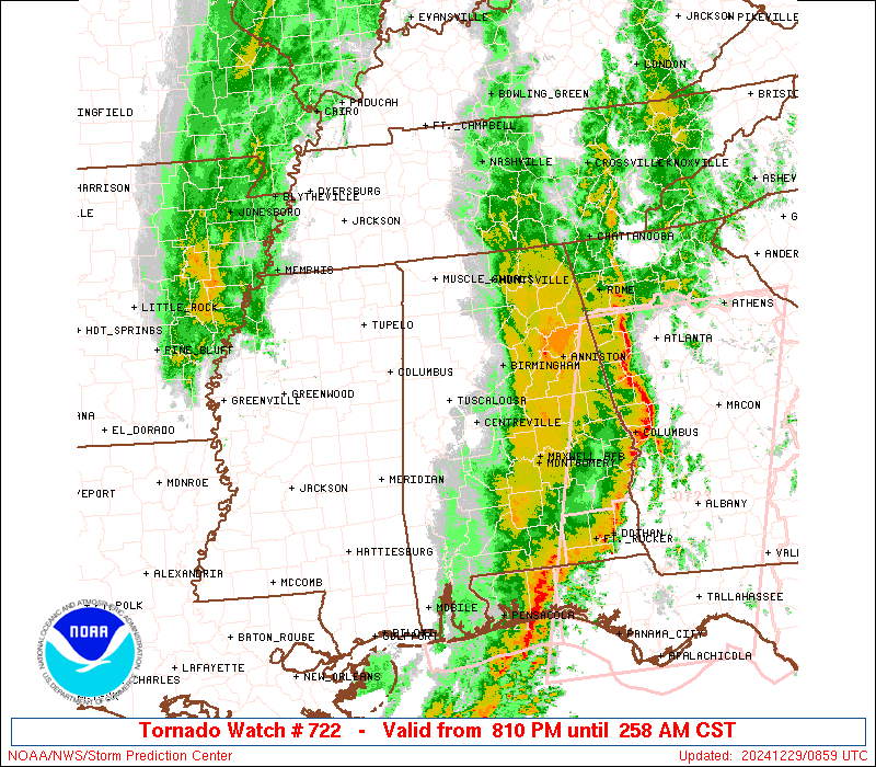
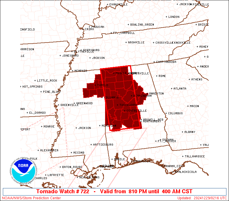
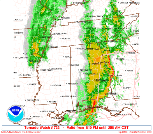
Tornado Watch Number 722
NWS Storm Prediction Center Norman OK
810 PM CST Sat Dec 28 2024
The NWS Storm Prediction Center has issued a
* Tornado Watch for portions of
Northern and Central Alabama
Northeast Mississippi
* Effective this Saturday night and Sunday morning from 810 PM
until 400 AM CST.
* Primary threats include...
A few tornadoes likely with a couple intense tornadoes possible
Scattered damaging winds likely with isolated significant gusts
to 75 mph possible
Isolated large hail events to 1 inch in diameter possible
SUMMARY...A line of thunderstorms should continue to pose some
threat for a few tornadoes and scattered to numerous damaging winds
as it moves east-northeastward this evening and overnight. Any
sustained supercell ahead of the line could produce a strong
tornado, although severe/damaging winds should eventually tend to
become the main threat overnight.
The tornado watch area is approximately along and 50 statute miles
east and west of a line from 20 miles north northeast of Muscle
Shoals AL to 30 miles southwest of Selma AL. For a complete
depiction of the watch see the associated watch outline update
(WOUS64 KWNS WOU2).
PRECAUTIONARY/PREPAREDNESS ACTIONS...
REMEMBER...A Tornado Watch means conditions are favorable for
tornadoes and severe thunderstorms in and close to the watch
area. Persons in these areas should be on the lookout for
threatening weather conditions and listen for later statements
and possible warnings.
&&
OTHER WATCH INFORMATION...CONTINUE...WW 720...WW 721...
AVIATION...Tornadoes and a few severe thunderstorms with hail
surface and aloft to 1 inch. Extreme turbulence and surface wind
gusts to 65 knots. A few cumulonimbi with maximum tops to 500. Mean
storm motion vector 26040.
...Gleason
SEL2
URGENT - IMMEDIATE BROADCAST REQUESTED
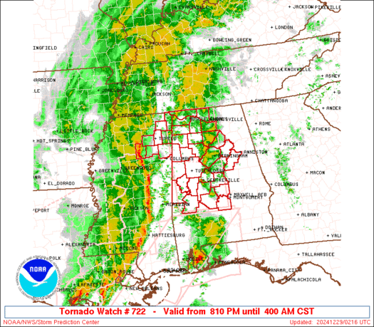
Tornado Watch Number 722
NWS Storm Prediction Center Norman OK
810 PM CST Sat Dec 28 2024
The NWS Storm Prediction Center has issued a
* Tornado Watch for portions of
Northern and Central Alabama
Northeast Mississippi
* Effective this Saturday night and Sunday morning from 810 PM
until 400 AM CST.
* Primary threats include...
A few tornadoes likely with a couple intense tornadoes possible
Scattered damaging winds likely with isolated significant gusts
to 75 mph possible
Isolated large hail events to 1 inch in diameter possible
SUMMARY...A line of thunderstorms should continue to pose some
threat for a few tornadoes and scattered to numerous damaging winds
as it moves east-northeastward this evening and overnight. Any
sustained supercell ahead of the line could produce a strong
tornado, although severe/damaging winds should eventually tend to
become the main threat overnight.
The tornado watch area is approximately along and 50 statute miles
east and west of a line from 20 miles north northeast of Muscle
Shoals AL to 30 miles southwest of Selma AL. For a complete
depiction of the watch see the associated watch outline update
(WOUS64 KWNS WOU2).
PRECAUTIONARY/PREPAREDNESS ACTIONS...
REMEMBER...A Tornado Watch means conditions are favorable for
tornadoes and severe thunderstorms in and close to the watch
area. Persons in these areas should be on the lookout for
threatening weather conditions and listen for later statements
and possible warnings.
&&
OTHER WATCH INFORMATION...CONTINUE...WW 720...WW 721...
AVIATION...Tornadoes and a few severe thunderstorms with hail
surface and aloft to 1 inch. Extreme turbulence and surface wind
gusts to 65 knots. A few cumulonimbi with maximum tops to 500. Mean
storm motion vector 26040.
...Gleason
 Note:
The Aviation Watch (SAW) product is an approximation to the watch area.
The actual watch is depicted by the shaded areas.
Note:
The Aviation Watch (SAW) product is an approximation to the watch area.
The actual watch is depicted by the shaded areas.
   SAW2
   WW 722 TORNADO AL MS 290210Z - 291000Z
   AXIS..50 STATUTE MILES EAST AND WEST OF LINE..
   20NNE MSL/MUSCLE SHOALS AL/ - 30SW SEM/SELMA AL/
   ..AVIATION COORDS.. 45NM E/W /19N MSL - 53WSW MGM/
   HAIL SURFACE AND ALOFT..1 INCH. WIND GUSTS..65 KNOTS.
   MAX TOPS TO 500. MEAN STORM MOTION VECTOR 26040.

   LAT...LON 35008660 32048649 32048820 35008837

   THIS IS AN APPROXIMATION TO THE WATCH AREA.  FOR A
   COMPLETE DEPICTION OF THE WATCH SEE WOUS64 KWNS
   FOR WOU2.
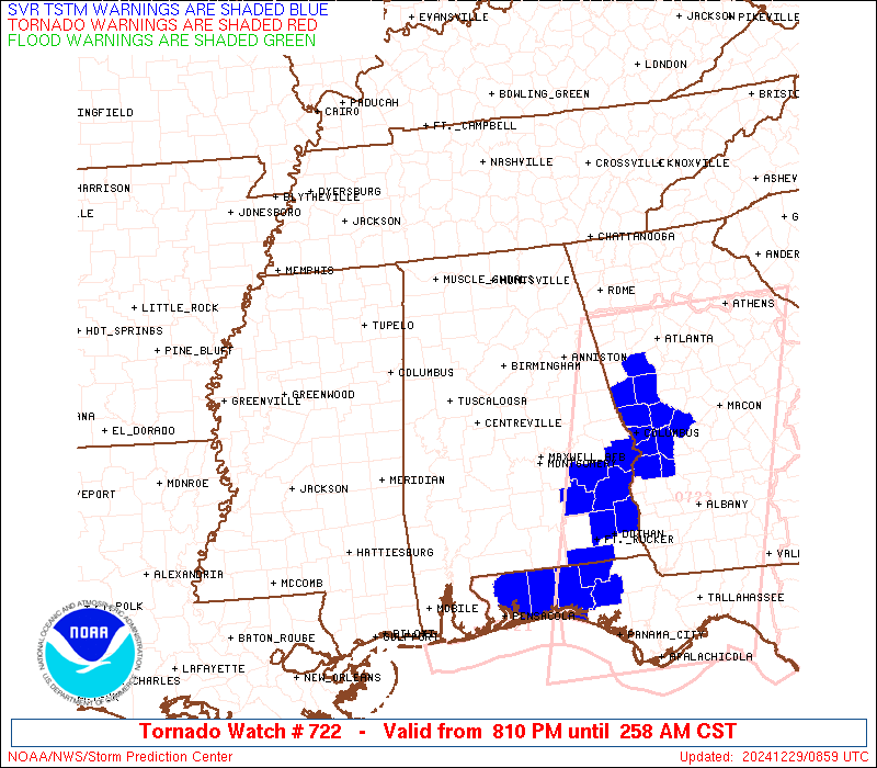
Watch 722 Status Report Messages:
STATUS REPORT #4 ON WW 722
VALID 290640Z - 290740Z
SEVERE WEATHER THREAT CONTINUES RIGHT OF A LINE FROM 15 SSE SEM
TO 25 SSE BHM.
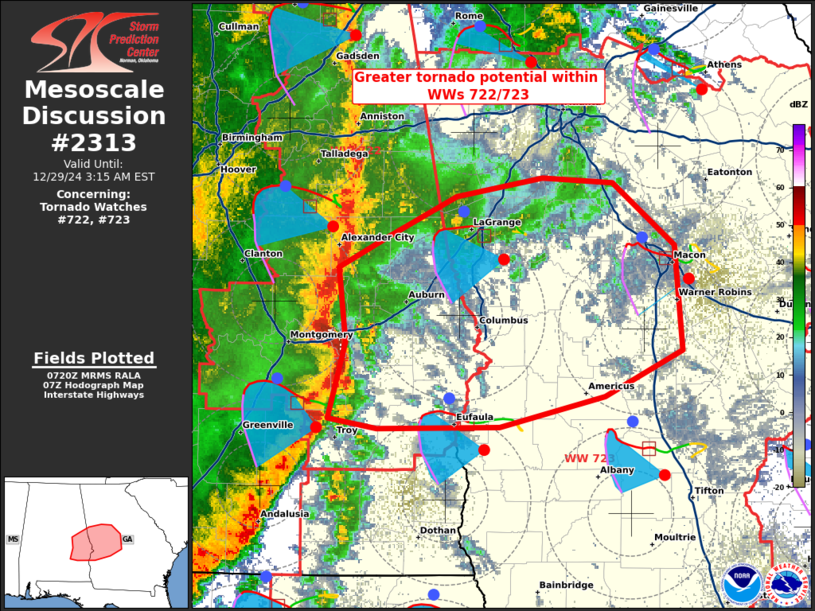
FOR ADDITIONAL INFORMATION SEE MESOSCALE DISCUSSION 2312.
..GRAMS..12/29/24
ATTN...WFO...BMX...HUN...MEG...
&&
STATUS REPORT FOR WT 722
SEVERE WEATHER THREAT CONTINUES FOR THE FOLLOWING AREAS
ALC001-005-011-015-017-019-027-029-037-049-051-055-071-081-085-
087-095-101-109-111-113-115-121-123-290740-
AL
. ALABAMA COUNTIES INCLUDED ARE
AUTAUGA BARBOUR BULLOCK
CALHOUN CHAMBERS CHEROKEE
CLAY CLEBURNE COOSA
DEKALB ELMORE ETOWAH
JACKSON LEE LOWNDES
MACON MARSHALL MONTGOMERY
PIKE RANDOLPH RUSSELL
ST. CLAIR TALLADEGA TALLAPOOSA
$$
TNC051-290740-
TN
. TENNESSEE COUNTIES INCLUDED ARE
FRANKLIN
$$
THE WATCH STATUS MESSAGE IS FOR GUIDANCE PURPOSES ONLY. PLEASE
REFER TO WATCH COUNTY NOTIFICATION STATEMENTS FOR OFFICIAL
INFORMATION ON COUNTIES...INDEPENDENT CITIES AND MARINE ZONES
CLEARED FROM SEVERE THUNDERSTORM AND TORNADO WATCHES.
$$
STATUS REPORT #3 ON WW 722
VALID 290520Z - 290640Z
SEVERE WEATHER THREAT CONTINUES RIGHT OF A LINE FROM 60 SE MEI TO
35 NW SEM TO 15 NNE TCL TO 50 NW BHM TO 20 W HSV TO 30 N MSL.
FOR ADDITIONAL INFORMATION SEE MESOSCALE DISCUSSION 2310
..THORNTON..12/29/24
ATTN...WFO...BMX...HUN...MEG...
&&
STATUS REPORT FOR WT 722
SEVERE WEATHER THREAT CONTINUES FOR THE FOLLOWING AREAS
ALC001-005-007-009-011-015-017-019-021-027-029-037-043-047-049-
051-055-071-073-081-083-085-087-089-095-101-103-105-109-111-113-
115-117-121-123-127-290640-
AL
. ALABAMA COUNTIES INCLUDED ARE
AUTAUGA BARBOUR BIBB
BLOUNT BULLOCK CALHOUN
CHAMBERS CHEROKEE CHILTON
CLAY CLEBURNE COOSA
CULLMAN DALLAS DEKALB
ELMORE ETOWAH JACKSON
JEFFERSON LEE LIMESTONE
LOWNDES MACON MADISON
MARSHALL MONTGOMERY MORGAN
PERRY PIKE RANDOLPH
RUSSELL ST. CLAIR SHELBY
TALLADEGA TALLAPOOSA WALKER
$$
TNC051-103-127-290640-
TN
. TENNESSEE COUNTIES INCLUDED ARE
FRANKLIN LINCOLN MOORE
$$
THE WATCH STATUS MESSAGE IS FOR GUIDANCE PURPOSES ONLY. PLEASE
REFER TO WATCH COUNTY NOTIFICATION STATEMENTS FOR OFFICIAL
INFORMATION ON COUNTIES...INDEPENDENT CITIES AND MARINE ZONES
CLEARED FROM SEVERE THUNDERSTORM AND TORNADO WATCHES.
$$
STATUS REPORT #2 ON WW 722
VALID 290425Z - 290540Z
THE SEVERE WEATHER THREAT CONTINUES ACROSS THE ENTIRE WATCH AREA.
FOR ADDITIONAL INFORMATION SEE MESOSCALE DISCUSSION 2310
..THORNTON..12/29/24
ATTN...WFO...BMX...HUN...MEG...
&&
STATUS REPORT FOR WT 722
SEVERE WEATHER THREAT CONTINUES FOR THE FOLLOWING AREAS
ALC001-007-009-021-033-037-043-047-051-057-059-063-065-073-075-
077-079-083-085-091-093-101-103-105-107-109-115-117-119-121-125-
127-133-290540-
AL
. ALABAMA COUNTIES INCLUDED ARE
AUTAUGA BIBB BLOUNT
CHILTON COLBERT COOSA
CULLMAN DALLAS ELMORE
FAYETTE FRANKLIN GREENE
HALE JEFFERSON LAMAR
LAUDERDALE LAWRENCE LIMESTONE
LOWNDES MARENGO MARION
MONTGOMERY MORGAN PERRY
PICKENS PIKE ST. CLAIR
SHELBY SUMTER TALLADEGA
TUSCALOOSA WALKER WINSTON
$$
THE WATCH STATUS MESSAGE IS FOR GUIDANCE PURPOSES ONLY. PLEASE
REFER TO WATCH COUNTY NOTIFICATION STATEMENTS FOR OFFICIAL
INFORMATION ON COUNTIES...INDEPENDENT CITIES AND MARINE ZONES
CLEARED FROM SEVERE THUNDERSTORM AND TORNADO WATCHES.
$$
STATUS REPORT #1 ON WW 722
VALID 290330Z - 290440Z
THE SEVERE WEATHER THREAT CONTINUES ACROSS THE ENTIRE WATCH AREA.
..THORNTON..12/29/24
ATTN...WFO...BMX...HUN...MEG...
&&
STATUS REPORT FOR WT 722
SEVERE WEATHER THREAT CONTINUES FOR THE FOLLOWING AREAS
ALC001-007-009-021-033-037-043-047-051-057-059-063-065-073-075-
077-079-083-085-091-093-101-103-105-107-109-115-117-119-121-125-
127-133-290440-
AL
. ALABAMA COUNTIES INCLUDED ARE
AUTAUGA BIBB BLOUNT
CHILTON COLBERT COOSA
CULLMAN DALLAS ELMORE
FAYETTE FRANKLIN GREENE
HALE JEFFERSON LAMAR
LAUDERDALE LAWRENCE LIMESTONE
LOWNDES MARENGO MARION
MONTGOMERY MORGAN PERRY
PICKENS PIKE ST. CLAIR
SHELBY SUMTER TALLADEGA
TUSCALOOSA WALKER WINSTON
$$
MSC013-017-057-081-095-115-117-141-290440-
MS
. MISSISSIPPI COUNTIES INCLUDED ARE
CALHOUN CHICKASAW ITAWAMBA
LEE MONROE PONTOTOC
PRENTISS TISHOMINGO
$$
THE WATCH STATUS MESSAGE IS FOR GUIDANCE PURPOSES ONLY. PLEASE
REFER TO WATCH COUNTY NOTIFICATION STATEMENTS FOR OFFICIAL
INFORMATION ON COUNTIES...INDEPENDENT CITIES AND MARINE ZONES
CLEARED FROM SEVERE THUNDERSTORM AND TORNADO WATCHES.
$$
Note:
Click for Complete Product Text.
Tornadoes
Probability of 2 or more tornadoes
|
Mod (60%)
|
Probability of 1 or more strong (EF2-EF5) tornadoes
|
Mod (40%)
|
Wind
Probability of 10 or more severe wind events
|
High (70%)
|
Probability of 1 or more wind events > 65 knots
|
Mod (40%)
|
Hail
Probability of 10 or more severe hail events
|
Low (20%)
|
Probability of 1 or more hailstones > 2 inches
|
Low (10%)
|
Combined Severe Hail/Wind
Probability of 6 or more combined severe hail/wind events
|
High (80%)
|
For each watch, probabilities for particular events inside the watch
(listed above in each table) are determined by the issuing forecaster.
The "Low" category contains probability values ranging from less than 2%
to 20% (EF2-EF5 tornadoes), less than 5% to 20% (all other probabilities),
"Moderate" from 30% to 60%, and "High" from 70% to greater than 95%.
High values are bolded and lighter in color to provide awareness of
an increased threat for a particular event.


 @NWSSPC